
|
|
Mountain/Rock |
|---|---|
|
|
39.93613°N / 16.27921°E |
|
|
Potenza |
|
|
Hiking, Trad Climbing, Scrambling |
|
|
Spring, Summer, Fall, Winter |
|
|
5433 ft / 1656 m |
|
|
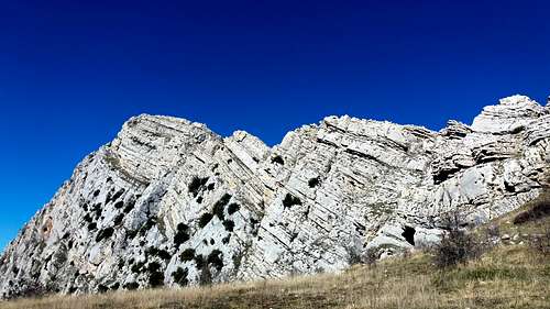
Timpa della Falconara
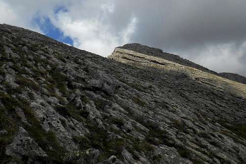
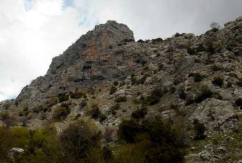
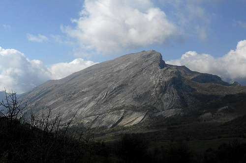
Timpa della Falconara, or often simply La Falconara, is one of the more remote peaks of the eastern extension of the Pollino massif and rather rarely frequented by hillwakers. It's a mecca for rock climbers, though. Like the majority of the peaks in this vast area also La Falconara features an impressive vertical rock face. Indeed, together with the enormous west face of Timpa di San Lorenzo, the perpendicular and pyramidal south-west face is one of the most striking sights of this sub-range. Although much lower than the 2,000 meter peaks of the central area, the slopes of these mountains are generally perpendicular, stark and almost devoid of any kind of vegetation that exceeds a few meters. The massive limestone slabs are bare, craggy and can show some very interesting structures. The vegetation on the more gentle slopes and that of the surrounding meadows is densely growing Mediterranean shrub. Especially in late summer the whole area resembles subtropical grasslands.
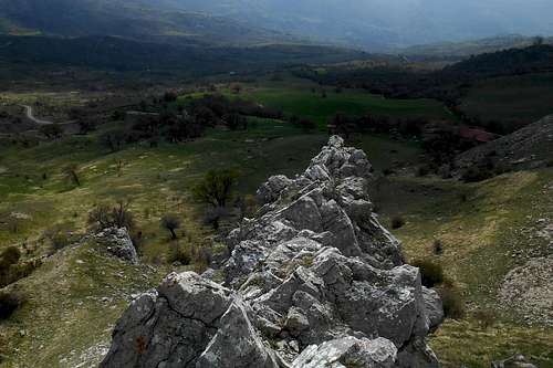
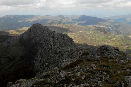
From the summit of La Falconara it is possible to enjoy a magnificent view on the gravelly lowlands that form the drainage of the Raganello torrent, the extensive beech forests at the foot of the mountains of the central part of the Pollino massif, the prolonged ridges of Serra di Crispo and Serra delle Ciavole, and the summit pyramid of Serra Dolcedorme.
Signposting is rarely found in this area and, apart from the dirt road that runs along the base of the south-east face of the mountain, there are no discernible hiking trails to follow. In order to reach the summit it is possible to use either one of the sharp ridges or to scale the central col which divides the summit from its northern foresummit. A full traverse is an easy scramble on compact limestone and probably the most diverting way to explore the mountain and its beautiful surroundings.
The south-west face and both the north and the south shoulder hold a variety of demanding climbing routes, in difficulty ranging from IV to VII+ (UIAA), i.e. from 5.4 to 5.10d (YDS). The quality of the limestone is surprisingly good when compared to that of some other mountains of the same area.
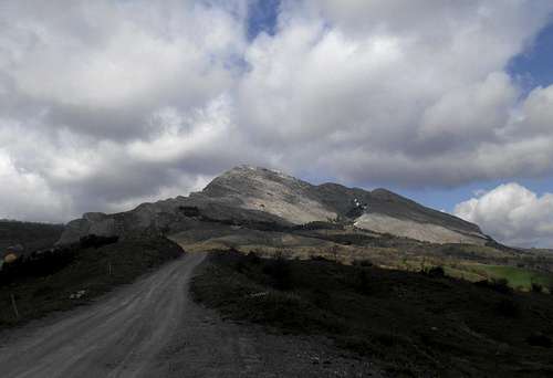 Timpa dela Falconara (from the south-east) | 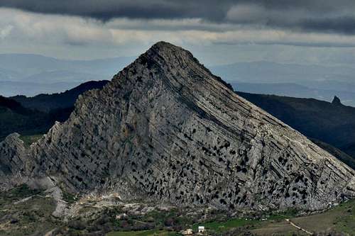 Timpa dela Falconara (from Timpa San Lorenzo) | 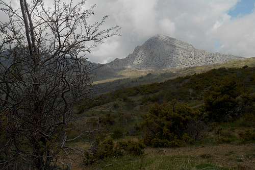 Timpa della Falconara (from Sant'Anna) |
Note: The term 'Timpa' is another word for mountain (ital. monte) and usually indicates mountains that feature a precipitous rock cliff or a particularly steep face on either one side. It finds a use especially in the southern parts of the Apennine mountains.
Routes
1. Hiking and scrambling routes
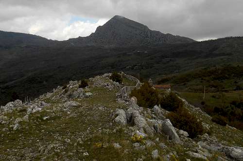
1.1 South ridge (from Casino della Forestale)
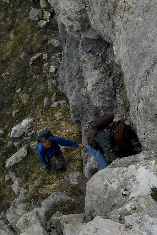
Scrambling on the south ridge
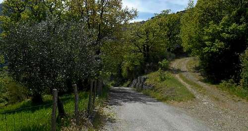
There are several junctions for other locations. Keep on the most evident road and don't take the road that dips toward the location "Barile" and the opening of the Raganello gorge. After this junction, however, keep on the road that skirts the west face of Timpa di San Lorenzo. In case of doubt always turn left.You may leave the car at the roadside short before reaching the 'Casino della Forestale', a large stone structure (see image below). Make sure to not block the passage for other vehicles.
Ascending towards the south ridge
Approaching the mountain: Simply keep on the broad dirt track that keep rising for another bit before it turns sharp left and flattens. The western slopes and the south ridge of Timpa della Falconara are now in sight. A few hundred metres before reaching the farm houses at the onset of the ridge leave the dirt road and traverse the grassland. There is no path to follow.
Ascend: Close to the base of the first solid rocks is a fenced pasture. Should you come upon the fence follow it in a northern direction (right). Where it ends the slope gets steeper and the grass gives way to large limestone slabs. An easy scramble in a more or less direct line will take you to the south ridge.
The ridge is largely easy to follow. Halfway up, however, you will come upon a steep rock ledge. There are several possibilities to climb the ledge, but you may also circumnavigate it on the right and climb up again to the south ridge. From this point it is only a few hundred meters to the summit which is marked by a large heap of stones.
Descend/way back: From the summit it is possible to descend on the same way. More interesting however, is a traverse, or at least descending via the north ridge to the central col. From the col it is a short and diverting scramble up to the northern foresummit of the mountain. Back on the col you may descend in a western direction. Simply follow the goat track, close to the rock face of the foresummit. At the foot of the slope the view opens on the vast shrub land. In order to return to the trailhead turn left and traverse the meadows until you come upon a rocky protrusion of the actual south-west face. Pass is on the left side and keep close to the escarpment. There is a narrow ledge descending towards a scree ramp that eventually will take you to the dirt road. The ledge itself is fairly exposed and consists of one very long and rounded limestone slab. The limestone is rather slick, so pay close attention not to slip here, especially when the surface is wet. Take the dirt track in a southern direction and keep following it when it turns left and descends into the forest. After passing a number of farm houses you will reach the point where you left the dirt road.
 Onset of the south ridge | 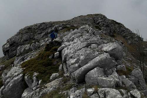 Descending towards the central col | 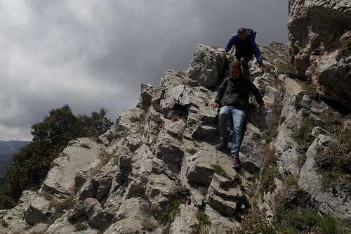 Descending along the western escarpment |
Additional excursion: In case you should feel the need for a somewhat longer hike you may also visit the small chapel Sant'Anna and enjoy a splendid view from the cliffs to the bottom of the Raganello torrent. In order to reach Sant'Anna simply take the dirt road that runs from the base of Timpa della Falconara in a southern direction, towards the northern escarpment of Timpa di San Lorenzo. Right behind the chapel starts a hidden trail which runs along the base of the ridge and descends towards the cliffs, a drop of several hundred meters. At a certain point you will have to cross a small rivulets whose waters precipitate over the cliffs and down into the Raganello torrent.
Following the cliffs in direction of the north-west escarpment of Timpa di San Lorenzo you will enjoy fantastic views and find a natural arch and several smaller caves. Along the base of the north-west escarpment runs a not easily discernible trail that descends towards the bottom of the Barile gorge and the Raganello torrent.
 North-west escarment of Timpa di San Lorenzo | 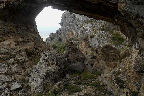 Natural arch (Sant'Anna) | 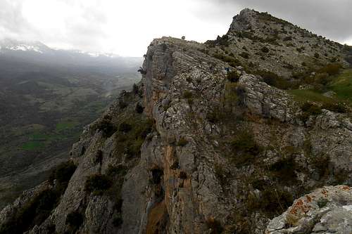 Cliffs of Sant'Anna |
1.2 North ridge (from "Lago Duglia")
Northern foresummit and north ridge
(Note: Because of snow and landslide the road may become impassable during the winter month and after heavy rainfalls and/or only approachable with 4WD.)
Approaching the mountain: Keep on the broad forest track that continues in a southern direction before turning east. After one kilometre you will come to pass the closed mountain hut "Rifugio Segherina". The forest track is now skirting the north slopes of Toppo Vuturo (1,671 m). After another kilometre the forest opens. Do not follow the road that swerves south but take take the hiking path that continuous in a western direction. From here it should be possible to catch a first glimpse at Timpa della Falconara. Keep on the hiking path and pass the first bigger rocks of the north ridge.
Ascend: Now turn right (south) and leave the trail altogether in order to scale the ridge. Occasionally you may come upon some sparse signposting (red and white) on larger boulders and rocks, but the reach does not pose any difficulty and may be follow in its entirety. After a short while you will reach the northern foresummit which will already award you with some splendid views (to the north: Terranova di Pollino and the reservoir "Diga di Monte Cotugno"; to the south-west: the higher peaks of the central Pollino massif; to the south: the wide plain of Bellizzi, the col and the north ridge that leads up the summit).
A real quick and easy descend will take you directly to the central col from where you will only have to follow the north ridge that rises in a semicircle to the actual summit of the mountain.
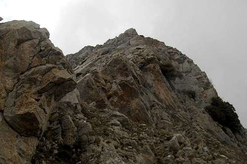 Rock face La Falconara | 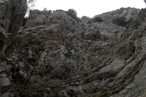 Rock face La Falconara |
2. Climbing routes
By now there are dozens of interesting climbing routes on this cliff, both on the central wall ("Paretone") of the south-west face and along the walls beneath the north and south ridge ("Spalla sinistra" & "Spalla destra") of Timpa della Falconara. Some of those routes have been partially equipped with pitons and bolts, for example the straightforward "Via dei Bellonesi" (3 pitches, max. V-), "Araknophobya" (3 pitches, max. IV+) and "Thor" (2 pitches, max. V) - all three climbable with very basic equipment (quickdraws, some accessory cord, a few biners). The difficulty of the routes that run the central wall ranges, depending on the route, can reach a respectable VII+ (UIAA), i.e. expect pitches that reach from a nice and easy 5.4 to a trying 5.10d (YDS). Keep in mind that these long routes (up to 8 pitches) will have to be negotiated almost without any fixd protection in place.
Timpa della Falconara, from the south
As there are simply too many conceivable routes on this cliff to describe them all in detail here. A short-list of the more frequently repeated routes:
1. Sabrina per poco - wall - max. VII (8 pitches) 2. Mistero - wall - max. V (3 pitches ??) 3. Trono degli dei - shoulder (r.) - max. IV+ (3 pitches) 4. Fulmini di Zeus - shoulder (r.) - max. VII+ (3 pitches) 5. Gang bang - shoulder (r.) - max. VI (3 pitches) 6. Gran Capucin - shoulder (r.) - max. IV+ (3 pitches) 7. Ottobre rosso - shoulder (r.) - max. VI (3 pitches) 8. ... e i doboli soffriranno - central wall - max. VI+/A (8 pitches) 9. Iperadreno Caoustico - wall - max. V- (2 pitches) 10. Thor - shoulder (r.) - max. V (2 pitches) 11. Via dei Bellunesi - shoulder (r.) - max. V- (3 pitches) 12. Aracnophobia - shoulder (r.) - max. IV (3 pitches) |
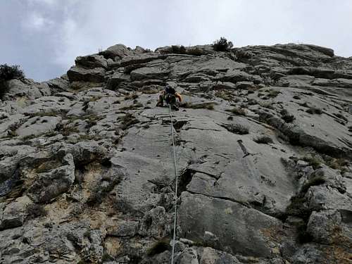 Falconara, Via dei Bellunesi, 1st pitch | 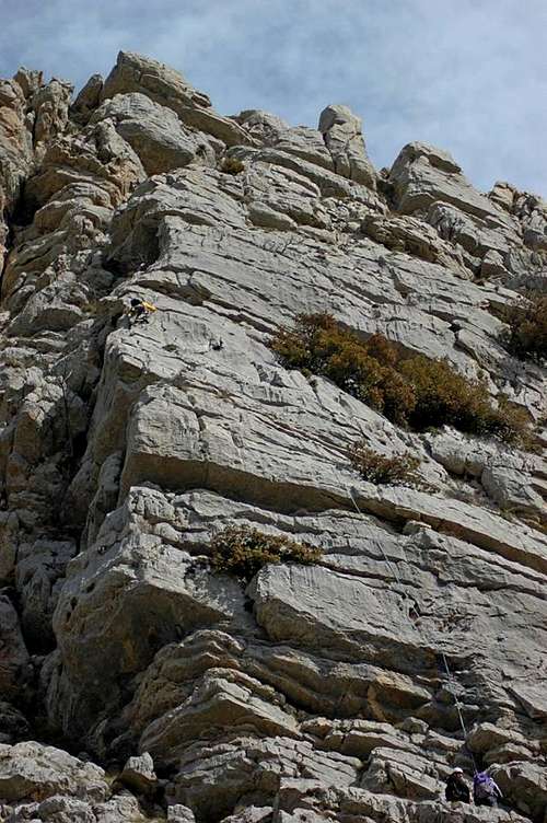 2nd pitch | 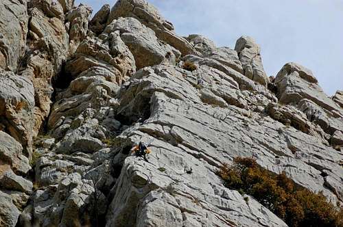 Falconara, Via dei Bellunesi, 2nd pitch |
* route evaluation: rocciaeresina.it
A few landmarks & impressions
 Timpa di San Lorenzo (from the north-east) | 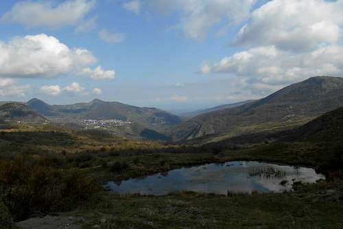 Terranova di Pollino (from the south trail) | 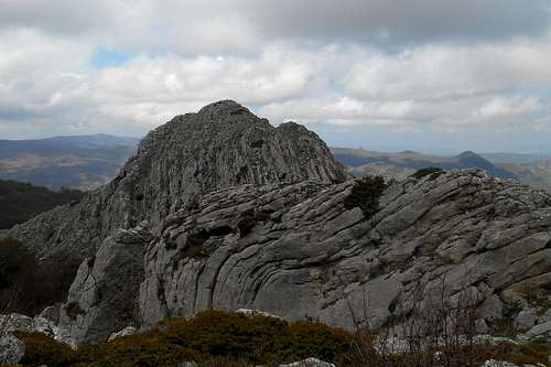 The northern foresummit |
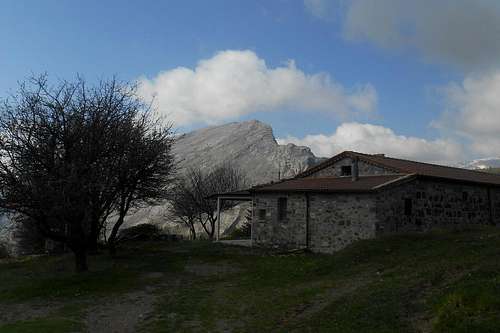 Casino della Forestale & Timpa di San Lorenzo | 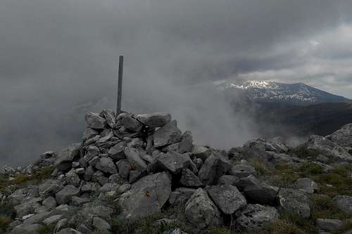 Timpa della Falconara (summit) | 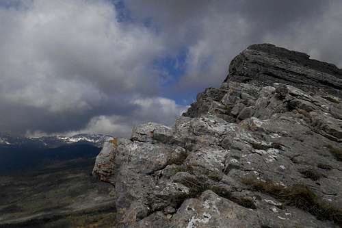 The south ridge |
 La Falconara (from Sant'Anna) | 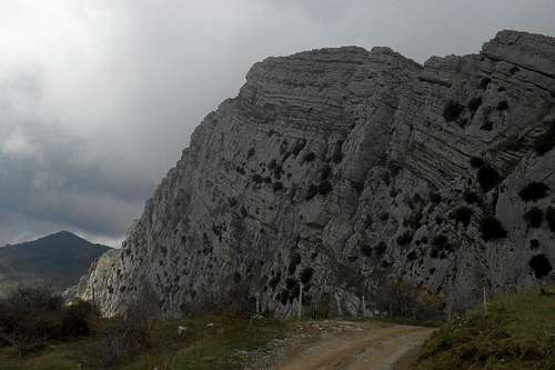 The south-west face | 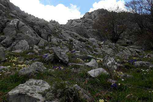 At the foot of the central col |
Getting there
The nearest airports are Naples (about 230 km), Bari and Brindisi (also about 220-230 km). From Rome and its big international airports it is a considerably long journey of almost 450 km. There is limited public transport in this region. Trains will go as far as Potenza and Matera (Basilicata, FAL) or Scalea or Sibari (Calabria, FS). Buses do operate infrequently between some of the bigger towns and villages, but are rather unreliable. Hence, visitors will mostly depend on private transport in order to reach the villages or trailsheads mentioned above.
The actual mountain roads are largely in bad conditions, especially the high passes might become impassable after snowfalls as road patrol service is scarcely to be seen around. If you should consider to visit the Pollino Massif between late October through early May, don't forget to bring snow chains or allow extra time for the approach way.
Country road (in vicinity of the trailhead Barile)
- from Napoli: Take the A3/E45 in direction Reggio Calabria, Salerno (about 195 km). Take the Exit (Uscita) Lauria Sud and follow the state the State Road SS19. Leave the A3/E45 at the location Pecorone and follow indications for the State Road SS653 (called "Sinnica"). Take the Exit Val Sarmento and follow indications for Terranova di Pollino.
- from Bari: Take the State Road SS100 (or the highway A14/E843) for Taranto. Turn left (indications for Jonica/Palagiano/Matera/Reggio Calabria) and take the coastal road E90. After passing Policoro pay attention, as he Exit can easily be miss, and turn left, taking the State Road SS653 (indications for "Sinnica". Take the Exit Val Sarmento and follow indications for Terranova di Pollino.
- from Brindisi: Simply take the E90 for Taranto and keep on this road. After Taranto follow the same indications as above (Bari). In case you should want to approach from the south, keep on the E90 and exit after Sibari, taking the SS534 (indications for Castrovillari). From here you can easily reach the villages of Civita, Frascineto, San Lorenzo Bellizi or Cerchiara di Calabria.
Red Tape
La Timpa della Falconara and its surrounding are an integral part of the Pollino National Park. With its 1,960 square kilometres it is the most extensive national park in Italy. The park was officially founded in 1988. The same rules apply as for other national parks in Italy. Free camping is generally not encouraged. But it might be tolerated from dusk until dawn and as emergency bivouac. No open fire etc. will be tolerated, though. No fees or permits are required.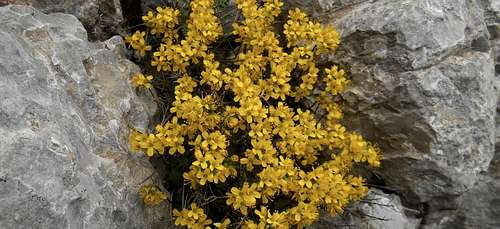
Saint John's wort (Hypericum perforatum)
The mountain roads that lead up to the trailheads are passing close to several smaller settlements and farm houses. These roads are ill-conditioned, steep and narrow. When leaving your car, make sure to park it where it will not block the passage for other vehicles. Watch out for grazing animals.
When to Climb
Given its moderate elevation the latitude, this mountain can be climbed all year round. Even in winter the ridges should be accessible without mountaineering gear. The hiking and scrambling routes are easy and orientation should not pose major problems. Even with low clouds the ridges running in a north-south direction are quite evident. However, after rainfalls the slick limestone slabs are not to be underestimated, and the exposure is substantial. Snow and ice are to be expected from late november through march. The demanding climbing routes of the pyramidal south-west wall is for experienced climbers with full climbing equipment and protection gear.
Best season, for both scrambling and climbing, is during the months of spring, but also throughout the summer month and early autumn an ascent is highly recommendable.
Accommodation, mountain huts etc.
The approach on either of the hiking trails is neither very long nor demanding. Even a full traverse won't take much more than half a day. No need for a bivouac or a mountain hut. Indeed, there is no such place in the vicinity. Accommodation can be found easily at one of the bed & breakfast in Terranova di Pollino (north) or Cerchiara di Calabria (south). Another option is an overnight stay in the also very scenic calabrian village Civita (south). Terranova di Pollino |  Cerchiara di Calabria |  Civita |
Maps & Guidebooks
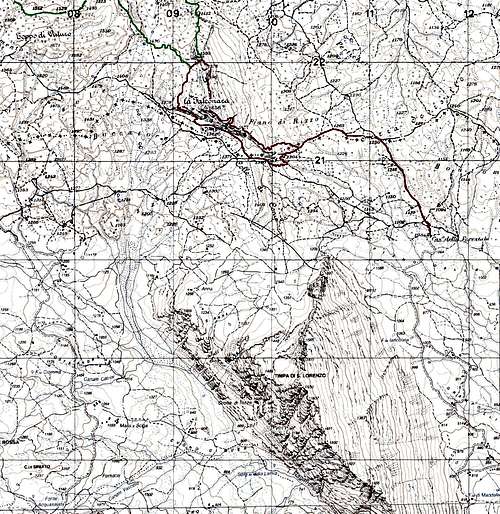 Map - Routes (1:25.000 IGMI) - Timpa della Falconara |
|
- Sui sentieri del Pollino, author: Giorgio Braschi, Edizioni Pugliesi, 2nd Edition 2007. - Without any doubt still the most recommendable guidebook to this region, with several detailed maps (scale 1:25.000), a large removable map (scale 1:50.000), numerous itineraries and comprehensive information about the geological origins of the massif etc.
- A piedi sul Pollino, author: Emanuele Pissara, Edizioni Prometeo, 2001. - Guidebook containing more than 100 itineraries (with detailed descriptions, photographs and useful information).
- Carta Turistica - Parco Nazionale del Pollino, Edizioni Il Coscile, map scale 1:55.000
- Sud Verticale1, author: Guido Gravame, Idea Montagna, 2015. - Finally, a new guide book (in Italian language) with alpine routes, climbing routes etc. of the Pollino range and the Lucanian Apennines.
External Links
- www.rocciaeresina.it - a list of climbing routes on the south-west face of Timpa della Falconara (italian)
- www.bed-and-breakfast.it - bed & breakfasts (Civita and surroundings)