Last P2K peak in Nevada for Dennis
In Nevada, there are 169 peaks on the prominence list that pertains to peaks with over 2000 feet of prominence. Since two of these are in the off limits military reservation known as Area 51, that means you have 167 to do in order to get all of the peaks, quite an undertaking since they are scattered all over the state and most are only accessed by long drives on dirt roads with many of these requiring high clearance and 4 wheel drive. So when Dennis Poulin stood on top of the 11,000 foot plus mountain called Toiyabe Dome, it was a huge accomplishment and a fitting one to end his statewide effort on. It required a backpack for us since we tackled it in mid October and daylight is shorter at that time of the year although in June-July it would be a solid dayhike of 14 miles and over 5000' of elevation gain.
What exactly is prominence and why is it such a neat way evaluate mountains/peaks?
See the following links for some good explanations:
Scott Surgent's description
Richard Carey's description
County highpointer descriptionA little background
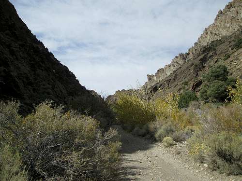
![Jett Canyon]() Jett Canyon
Jett Canyon
Dennis and I started hiking in Nevada back in 2004 when we decided to go after the Nevada county highpoints. Although I had visited the summit of Charleston Peak in 2003, it was in 2004 that we made the decision to jointly pursue the county highpoints. After we accomplished getting all the county highpoints, we wanted to continue hiking in Nevada, a state we had come to really like by focusing on the daunting
list of peaks with over 2000 feet of prominence. Prominence peakbagging is a fun pursuit and the prominence list was an exciting way to visit all the nook and crannies of the Silver state. I can't tell you how many miles on paved roads, dirt county roads, ranchers roads, 4 WD roads or almost no roads we pushed our trucks up (and down of course). I believe I've been in places like Austin, Tonopah, Ely, Elko etc dozens of times.
Dennis and I along with our friend Ken Jones, had really been making an effort to get finished in Nevada on this prominence list and since Dennis appeared to be in a great position to finish the list on Toiyabe Dome in 2014, he invited me to join with him and I jumped at the chance to join him and witness his completion of the list.
I hooked up with Ken Jones and Dennis near Milford Utah since we all had a desire to get the Milford Needle, one of my few remaining p2k's in Utah but as it turned out, only Dennis had the rock skills to get the 5.8 summit of that one with Todd Passey, a skilled rock climber from Salt Lake City. Ken Jones and I turned around mid way as we realized we were in over our heads. You can bet Ken will go back after working on his rock climbing skills so he can tackle the technical aspects of the Milford Needle.
After the Milford Needle event, Ken headed back to Seattle to join with his family and Dennis and I headed on to do Shingle Peak on the 12th and it was the second to last that Dennis needed and one that is rarely visited. I've put up a summitpost page for Shingle Peak if any of you reading this ever get intested so look there for more details. After Shingle, we went after Cherry Creek peak 11459, an error range peak that we needed but I won't try and explain what the heck an "error" range peak is, maybe some other time. We had an interesting day finding our way up the lonely roads and picking a spot to go after this remote and also seldom visited peak from. It was a good hike and we decided that there might be a better route up it than the one we chose. We ran into a few hunters lower down but the deer they were seeking were hiding out and Dennis and I spoted them as they did their best to avoid those seeking them. After Cherry Creek Peak, we headed south to Ely and a great Mexican dinner at Margarita's and from there to a campground mid way between Ely and Eureka.
The next morning, we got a late start and headed to Eureka where we had a good breakfast at the Pony Express Deli located on the south end of town. Then we continued our drive across the state to the small berg of Carvers, located just east of Toiyabe Dome. It is 110 miles from Eureka to Carvers and I throw that in just for reference. In Carvers, we stopped at the rest area and put together our backpacking needs, which included sleeping bags, stove, food and extra clothing. The temps at where we had stayed the night before had dropped to 25 and since we would be camping at the 8000 foot level, we needed to provide warm clothing for the temps we might face. It took longer than I expected to put the gear together since it was important to have all the necessary stuff. Dennis would carry the 2 man tent and I would carry the stove and fuel. I think this was my first backpack of the year since every other peak I had climbed were all day hike efforts.
After getting our stuff together, we headed down the road about 5 miles and found the turnoff to Jett Canyon.
The Jett Canyon route
There are two ways to climb Toiyabe Dome, one is called the Cove Creek route, a difficult albeit shorter route which requires careful routefinding both up and down and Jett Canyon, a longer but less demanding approach. We opted for Jett Canyon as we didn't think we could get up and down Cove safely with the amount of daylight we had to work with and Jett was more amenable for making a backpack out of it. Dennis could probably done Cove in one day but remember he was hiking with me, a 74 year old that doesn't move as fast as he once did. So Jett Canyon it was. Thanks to moapa peak's Jett Canyon page, we had some information about how to access this one. Greg Jagielski had also gone up this route and shared a home made map that he had created about the route that he had utilized.
![Trail in Jett Canyon]() Jett Canyon Trail Jett Canyon Trail | ![Ridge up from Jett Canyon]() Heading up from camp Heading up from camp | ![Our route to the ridgeline]() Aiming for that ridgeline Aiming for that ridgeline |
As we approached the mouth of Jett Canyon, I suddenly noticed about 20 big horn sheep cutting across the road ahead. They are such magnificient animals that it was a thrill to see that many all at once. We stopped and took several pictures but they did their best to ignore us and quickly moved out of sight. After driving across the cattle grate, it was decided that we would leave Dennis's bigger truck at the first logical place to park it and did so about a half mile up the canyon and the two of us continued on in my Tacoma. The canyon itself is a beautiful area with steep cliffy walls on both sides but in many places the brush closes in and you hear the sickening sound of branches attacking your paint job. There was one section of the road where we were actually driving up the stream bed but for the most part, the road was decent and after one wrong turn (we went right instead of left and round ourselves at a mining area) we found our way to the wilderness boundary at the 7000 foot mark. The road continues past the brown plastic wilderness markers and it was obvious that the ATV crowd paid little attention to the signs. One of the reasons for the road being there in the first place however was obvious, this was an important water source for those in the valley below and we could see remnants of old pipes and pumps in several places along the way.
It was about
3 pm when we hoisted our packs and started up the road, a fairly straightforward hike for the first mile and a half thanks to the road and ATV track. Then at the first real water crossing (the first of 12), the track turned into a trail and we found ourselves following some cattle, one or more of which seemed to have diarhrea , so we had to watch our step. After about 2 miles, we missed a turn in the trail and found ourselves wallowing through the brush and crossing the stream but fortunately, our lost situation ended when we rediscovered the trail on the other side. On the way back we found the trail where we had lost it and could see the reason why we got "lost". Anyway, after about 2 1/2 miles we found a decent place to set up our tent although it had a bit of a slope to it. Camp
spots were limited so we grabbed it since it was at 8000 feet and at the base of the ridge that we would be heading up the next day. What was nice about the spot is that the stream with flowing water was just about 25 feet away and was nice to have so close. We cooked up our yummy Mountain House dinners and the two man portion was more than I could gag down (Beef Stroganoff). I offered Dennis the extra I had and he smartly turned up his nose at the offer. I'm crossing that one off my list of Mountain House dinners.
![Our camp]() Home sweet home
Home sweet home
Night comes early in October and when the sun left us and the shadows closed in, it got cold and time for us to crawl into our hopefully warm sleeping bags. My bag was a 30 degree bag and not warm enough of course but the extra clothes I had helped do the job during the colder parts of the night. Laying on the ground for 12 hours is not something that I find overly restful so my sleep was divided into the awake/sleep cycles for most of the night. I think Dennis slept a lot better than me but that was only because when I was awake it seemed when he was sleeping and I was awake way too much.
Finally, although it didn't seem possible, morning finally showed up and I literally bounded out of the tent, ready to do battle with what we had in front of us.
Up the ridge
Not far from where we camped was the ridge we were going to head up. It was 2100 feet in about a mile and a half with no use trail or indication that any one else had ever been up it before us. Dennis had created some waypoints and after breakfast, we started on up. The ridge started off steep and Dennis seemed to divine a way that worked as we headed up the thing. We had sections of loose movable talus alternating with brush and steep dirt but about midway up, the loose talus seemed to be the main feature and while Dennis can waltz up that stuff, I am more of a leadfoot since I'm always afraid I'll twist an ankle or worse. Many years earlier, I tore up my medial medicus on some talus on a mountain in eastern Nevada so that memory always serves as a reminder of what bad could happen. This ridge wasn't a place where I wanted to call 911 from.
![Lots of talus on our way up]() Lots of steep talus Lots of steep talus | ![Route to Toiyabe Dome]() The route The route | ![On the route]() On route On route |
Thanks to my slowness (hey, I'm 74 years old these days), it took Dennis and I 3 hours to reach the top of the ridge at 10,100 feet. Dennis could easily have chopped an hour off that time since he was always waiting for me but he is a patient guy and doesn't grumble about my speed. I was concerned about the time it took especially when I looked over and saw that the summit was almost 3 GPS miles away. The terrain looked easy and I was relieved by that but what was unseen by either of us was the fact that that terrain undulated up and down and we would find ourselves losing and gaining a lot of the elevation again and again.
About two hours later, I began to run out of energy and I encouraged Dennis to go on without me since I really wanted him to get the summit and not be held back by me. Dennis said no way. He wanted me on that summit with him so he suggested I sit down, gobble some Gu and energy foods, drink half of a 20 oz Gatorade bottle I had in my pack and hydrate. I did as ordered and amazingly, I felt the energy flowing back into my legs and my determination returned and off we went.
To the summit
At the point I had wanted to cry uncle, the GPS said we had one more mile to the summit and our elevation was 10900 feet. As I followed Dennis, we went over the 11,200 foot level before we lost what seemed like 250 feet of elevation that we had to gain back. Now the terrain is easy and all class one although one side hill traverse really slowed us down as we avoided gaining an additional 100 feet on one of the peaklets but by putting one foot in front of the other, we ate the distance up and finally, we found ourselves on the final slope leading up to the summit.
![Still on route]() Dennis Dennis | ![Summit in sight]() Summit ahead Summit ahead | ![Dennis on final slope]() The home stretch The home stretch |
At this point I remembered my camera and started taking pictures of Dennis as he headed for the last summit he would need to complete the fabled Nevada p2k list (well at least its fabled to me). When Dennis reached the summit, he raised his arms in triumph and deservedly so. It was his 167th 2000 foot peak with prominence in Nevada and moved him to be the first person who ever accomplished such a feat (add another 9 error range peaks to that total to make it 176 and you have the real tally). A great hiker/climber John Vitz, whose name we would see on tons of peaks in Nevada had been the leader at 166. John only lacks Jumbo peak in the southern half of the state but he and Gordon MacLeod and Barbara Lilley were truly the "pioneers" of these types of peaks. Many of the peaks were visited with no information being available at the time they did it and they did not have the advantage of GPS technology in the earlier years. They studied the topographical maps and encountered success after much trial and error in many cases. What is also noteworthy is that Dennis accomplished his effort in 11 years. It took him 37 trips to Nevada to do so and thousands and thousands of miles of wear and tear on his trucks. Kudos to Dennis and to John, Gordon and Barbara.
![Looking down]() Looking down the Cove Creek route Looking down the Cove Creek route | ![Surveying his domain]() Surveying his domain Surveying his domain | ![Older register entries]() Register Register |
We knew it was getting later so after pics, checking the register and eating some snacks, we headed back down as we didn't want to be caught on the ridge leading down to camp after dark so we made our summit visit very short. Heading down we moved as fast as we could and it still took us 4 hours to get back to camp. Actually, we had about a half hour of daylight so we filtered water and made our dinners prior to settling down for the evening. Even though we were tired, we knew it would be another long night in the tent but we weren't tempted to try and make it down to our vehicles in the dark so it was the better of two choices. We started just at dawn and finished just before dusk so it was an all day affair. The amazing thing was: We got the doggone thing and would never have to come back unless we really wanted to for some crazy reason.
![Arc Dome]() Looking at Arc Dome Looking at Arc Dome | ![Looking east]() Looking east Looking east | ![Looking south]() Back to the south Back to the south |
Toiyabe Dome is one I definitely would never repeat but I'm thrilled to have gotten it. A couple thoughts about this one if I were to do it again would be:
1. Try and do it earlier in the year, perhaps August to have more daylight.
2. Camp again to get an edge but then try and pack out on the same day as the climb by having enough daylight to do so.
Some odds and ends
I am at 153 p2k summits in Nevada plus I have 6 of the 9 error range peaks done. I still have some work to do with 14 remaining and three error range peaks but I fully intend to stand on my last peak by my 75th birthday. Dennis and I have done 67 together and I need to mention another dedicated Nevada peakbagger, Ken Jones. Ken and I have also done about 67 together in Nevada and Ken has at the time of this writing 152 of Nevada's p2k's. I fully expect Ken to also finish the 167 as well as others like Greg Jagielski, Andy Martin, Mark Nichols, Richard Carey, Bob Sumner, Eric Kassan, Bob Packard, to name a few. Dennis won't be alone at the top but he is the first.
Dennis, Ken Jones and I have written lots of information about how we did the peaks and have willingly shared it on Summitpost,
peakbagger.com and through personal correspondence. I know our information may not always be the best but it what we did and I'm hopeful it has helped others in their pursuit of these peaks.
Kudos to John Vitz for his information as he has often come to my assistance on what route he used to climb one of these truly isolated and seldom visited mountains. He also shared a lot of his information on the yahoo prominence group on the net. I can't tell you how much I respect John for what he accomplished in Nevada and also Gordon and Barbara for placing so many registers. For example, when Greg Jagielski and I climbed Ray Benchmark near Cherry Creek, John Vitz was the only one signed into the register, a register placed 9 years earlier. When Dennis and I did Shingle Peak, once again he was the only one signed in for 9 years until Greg Jagielski climbed it in 2012. Dennis and I became only the 3rd and 4th. And so it goes. Often, once someone puts out information about how they did the mountain, many others will soon follow.
Others to thank:
Greg Jagielski has shared maps and information with me about many of the peaks he has done in Nevada. Greg is an incredible person and really fast. You may not have heard of this guy but if you climb prominence peaks in the west, you'll often see his entry in the registers. To his credit, he always willingly slows down to accomodate me and I appreciate that very much.
Richard Carey of San Diego, has also shared a lot of his information by putting up trip reports and maps.
Also special thanks to Eric Kassan, Bob Sumner, Adam Helman and Andy Martin for information that has been helpful to us in chasing these peaks in Nevada.


Comments
Post a Comment