
|
|
Mountain/Rock |
|---|---|
|
|
40.12760°N / 112.1731°W |
|
|
Tooele/Utah |
|
|
Hiking |
|
|
Spring, Summer, Fall, Winter |
|
|
6510 ft / 1984 m |
|
|
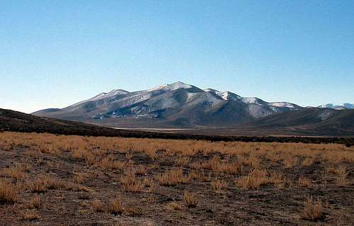 Looking south
Overview
For some reason I feel a fascination and a love for the peaks in the desert areas of Utah (as well as Nevada, Calif, & Arizona). Many of the peaks in the western Utah desert for example are unknown and obscure to the vast majority of Utah residents. However, everyone in Utah seem to be familiar with Mt. Timpanogos, Mt. Nebo, Lone Peak, etc, since they drive right by them almost every day on interstate highway I-15. As mountains, these are big and challenging in their own right and worthy of admiration and effort.Those mountains are all to the east of I-15 but once you start looking to the westward side of the interstate, most folks couldn't name what they are looking at. Well, maybe some can name the Oquirrh range but that might be about it. So, I can't fault anyone for not knowing the names of the ranges that are apparent on the western side so hopefully, this page will provide a bit more incentive for others to become familiar with one of these ignored and unknown gems that sits within an hour drive of Salt Lake City.
Topliff Hill was brought to my attention by a fellow ex-Washingtonian who has been quietly out climbing everything in the Utah, Salt Lake and Tooele county area. He has been on a quest to climb every peak that has a prominence of over 300 feet and his enthusiasm for doing so is infectious. SP member Eric Willhite Whether it is Lone Peak or Topliff Hill, Eric's name will be in the register. Before falling in love with Utah, Eric has climbed Denali and Aconcagua and much more. See Eric's fine website for more explanation (LINK) Thanks to Eric's inspiration, I've found out that these are good little peaks to do, good for conditioning and good for kids (if you have some that want to tag along) and good for the time of year when snow and avy danger might keep you out of the higher Wasatch mountains. Now on to Topliff Hill.
Topliff Hill was worthwhile to me since it has a prominence of over 1,000 feet and thus is on a list that a few others are chasing. Utah has 359 of these peaks that have over 1000 feet of prominence and Topliff Hill comes in at #229 on that list with 1222 feet of prominence. I know some will snicker at all of this prominence stuff, thinking it nonsense, but hey, believe me when I say it is fun. I've been on top of Rainier, Kings and Hood and some other nice peaks and truly enjoyed them but I also feel a sense of accomplishment each time I summit a peak, any peak. I enjoyed meeting Topliff's Hill summit up close and personal and was surprised to find that the register was placed there by two Californians who are legendary desert peak baggers, Gordon McLeod and Barbara Lilley. Those two along with John Vitz are desert peak climbers and those three have been climbing them for the past 40 plus years with several thousand to their combined credit. When you are out in the desert and you find a register on a desert peak, look for who put the register up there for you to sign, often it'll be one of the three listed above.
Topliff Hill involves no technical effort and can be rated as simply a hike so leave the ropes and slings at home. You could hike it from any direction and spend as little or as much time as you want exploring the area. While a passenger vehicle could get you fairly close if you take the main dirt road, to go further off the beaten track, it helps to have a high clearence vehicle, hopefully with 4WD as some of the roads out there can become
problematic if you encounter bad weather. Always be prepared with extra water, food, blankets and common sense if you should have a break down in any of the desert areas of Utah. Cell coverage is available in the Topliff area since it isn't all that far from the highway as will be mentioned in the getting there section.
Topliff Hill had a limestone quarry on its northern flank at one time and as recently as 2003 was in action. However, it appears the quarry has been abandoned and the big trucks that hauled the limestone north are no longer
a force to be reckoned with.

Getting There
From I-15, take exit 279 and go west on highway 73 towards Saratoga Springs and Eagle Mountain. This road can at times be very busy and in the late afternoon when everyone is headed home, progress may be slow, particularly from Lehi to the junction with Redwood Road. Set your odometer at this junction and head west towards Five Mile Pass, passing through the little berg of Cedar Fort on the way. Watch the speed limit, the highway between the Ranches turnoff and Five Mile Pass sees frequent Sheriff patrol vehicles and I have seen many pulled over receiving unwanted attention from the county's finest.
 View from Railroad Bed road on the way to Topliff
It is roughly 21 miles to 5 Mile Pass and the road you want is just beyond MP 16 snd the Tooele county sign before it curves to the north. Look for a dirt road on the left (south side). There are a couple dirt roads that take off just before this one so it is important to get the right one. If you overshoot the road, you will encounter the Pony Express road as it heads to Faust and it is a simple matter to just double back to find the correct road. (Benchmark map pg.50 E-6, Delorme map pg.24 C-4) After turning off, you will see an information board with a road heading straight ahead and a road going to the right of the information board. Take the road to the right and you will be on the Railroad Bed road, a well graded gravel road. The other road will get rutty and bumpy and doesn't get you to where you want to go very easily. Once on the Railroad Bed road, drive roughly 5.3 miles and look for a dirt road that angles to the left off the main road. Follow this road and head east for 3 miles. If this road is wet or muddy, you might want to park back at the railroad grade road and make a longer hike out of your effort as wet roads in this area mean mud, something you will want to avoid.
It is possible to park fairly close to the mountain and I was able to park at this GPS coordinate (long/lat nad 27) 40.1391 -112.1714 Elev 5565.
There are other roads that will get you to the base of the mountain but that adds to a bit of the fun and exploration aspect. Be aware of cattle as they were very much present in the area we parked in. We had to wait patiently for them to move off the road in a couple spots. We also encountered a couple dirt bikers and atv enthusiasts during our visit.
Route & Register
I can tell you that this peak could be climbed from any direction. From where I parked, it was not more than a mile since I drove fairly close to the route I wanted to use and it was close to a thousand feet of elevation gain. Not a bad workout and even better if you are willing to walk all the bumps that you can find since they are fun and easy to do.
Figure on a couple miles round trip and a thousand feet of elevation gain. Or you can do several miles and add more elevation as SP member giegiels did due to muddy roads.
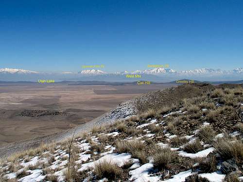
The views are outstanding as I mentioned earlier and as you can tell from the register pages below, it isn't often used to seeing visitors. 2005, 2008, 2009.
Since 2009, a number of others have discovered this little gem out in the middle of nowhere. See Lists of John.


Red Tape
There are few limitations in this area as the land is BLM land. However, while hiking up the mountain via the approach I used, I had to detour around a marked off section that was marked for no trespassing. I suspect the area might have had a mine shaft since the markers were positioned in a way as to only mark off a certain area and could easily be bypassed by staying outside the markers (faded with time and hard to read for the most part).I saw no gates to open or close but cattle grates were in place at fence crossings. I did encounter cattle and drove slowly to allow them to pass or get around me.

Camping
Most likely you wouldn't need to camp in this area unless you arrived very late in the day. Just off of highway 73, there are a few places with vault toilets that you could probably car camp near. Also, since it is BLM land, you could find a place to camp, practicing leave no trace camping practices. On the dirt road, just after the information sign I mentioned in the "getting there" section, the road I warned against taking does lead to a couple areas that the BLM has designated for camping and has vault toilets present. These are camping areas created most likely for the ATV / dirt biker crowd so you might be sharing these campsites should you select one of them.Weather (nearby Saratoga Springs)

Google Map
View Larger Map
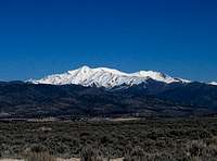
 Boulter Peak from Topliff Summit
 Looking NW
Other local peaks of interest
While in the area, you might enjoy a few more to do that are simple hikes yet have over 300 feet of prominence:Links are to Eric Willhites fine site
Thorpe Hills HP (Lava Benchmark)
Cat Hill
Greeley Hill
Blowhole Hill
Wanlass Hill
Pinyon Peak
Boulter Peak

Thorpe Hills
Interestingly enough, the Benchmark found atop the Thorpe Hills Highest point is called "Lava". It was hidden under some rocks (which I replaced) and is shown below along with some other pics on Eric's page of this fun little range that is just off of highway 73 and a good leg stretcher for those seeking a quick hike. See Eric's page for more info.List of John page for Thorpe Hills
