
-
 7648 Hits
-
 0% Score
-
 0 Votes
|
|
Route |
|---|---|
|
|
38.20000°N / 75.10000°E |
|
|
Snow/Glacier Climb |
|
|
Expedition |
|
|
Walk-up, possible crevasses |
|
|
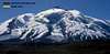
Approach
This route can be reached both from Kashgar or Islamabad since it begins along the Karakoram highway. If you are coming from Kashgar continue past karakul lake and Subashi. Continue on the highway until you reach the top of a pass where there is small gate and guard shack. There is also a sign saying, "Tashkurgan Tajik Autonomous County". From this point you can begin walking towards the mountain. The approach to basecamp is straight forward. The terrain is dry sand, rocks, and tundra over rolling hills.
There was no established base camp when we did this route however I believe there are two hut/yurts that will hopefully be there permanently. This route is in a different jurisdiction then the more common (Normal Route); it is in Tajik county. Local Tajik men and donkeys can be arranged to haul gear to basecamp. They can be arranged in Kashgar or hopefully located on sight.
 |  |  |
Route Description
Outline of the new (traditional) route:
Basecamp (4500 meters):
This basecamp is about 50 meters higher in elevation than the normal route’s basecamp. Basecamp is situated on a grassy, rocky area. It is quite comfortable, but the overall area to pitch tents is smaller than the normal route’s.
Basecamp to Camp 1 (5400 meters):
Walk up left side of rocky slope. Snow line for snowshoers starts at around 5200 meters. There is easy access to the snow for skiers to start skinning up at around 5050-meter elevation. Camp 1 is on a gentle slope. From camp 1 back down there is a fun snow gully to ski.
Camp 1 to Camp 2 (6170 meters):
Go straight up slope from camp 1. Go through “bowl” with crevasses visible on left and right. When going through this area stays on right flank. Then meander left and up on left side of slope. You intermittently have views of the normal route and stunning views of the Kartamak Glacier. Camp 2 is near where the Kartamak Glacier begins to cut aggressively into the mountain.
Camp 2 to Camp 3 (6800 meters):
A few hundred meters out camp 3 you have to navigate between two wide crevasses. The trail between them is obvious and safe. Then continue straight up slope until about 6400+ meters, turn slightly left towards the mass of broken up crevasses, and follow gentle slopes to camp 3.
Camp 3 to Summit (7546 meters):
Climb straight up out of camp 3. You will soon pass a crevasse on your left. Continue until 7050-meter elevation. At his point you are in a saddle between the main peak and Kalaxong Peak (7277) in front and to the right. At this point the mess of broken up crevasses separating you from the main peak slope come to an end. Go left up the summit slope. From here it is a straight shot to the top. Before reaching the summit you will pass an outcropping of rocks on your right. Stay to the left of these rocks. This is not the top yet. A little further the slope plateaus and you are going along nearly flat, frozen snow. Finally, you will see two prominent stone mounds. The one on the left is the true summit.
Comparison of the normal route and the new (traditional) route:
New (traditional) route:
1. Impressive views of the Kartamak glacier and the huge rock cliff it carves into the middle of the mountain.
2. Safer and more enjoyable ski descent and ascent.
3. Overall route slightly longer
4. Overall slope angle more consistent.
5. Less teams and climbers on the route.
6. Team’s equipment carried to basecamp by donkeys.
Normal route:
1. Impressive views of Mt. Gongar.
2. Not as friendly to skiers because of camp 1 to camp 2 ice field.
3. Overall route slightly shorter.
4. Couple of very short steep slopes between camp 1 and camp 2
5. Many teams and climbers on the route.
6. Team’s equipment carried to basecamp by Camels.
(The route description was written by Jon Otto. For a more detailed account of the new route read the trip report section)
 |  |
Essential Gear
Kashgar: shorts, t-shirts, sun hat, sun glasses, good walking shoes/sandals
Mustagh Ata: High altitude mountaineering clothing (gore-tex layers, down jacket, synthetic layers, fleece layers). Mix and match accordingly. An assortment of gloves and head protection too. I found the hardest element to deal with was the sun. Bring a thin gloves and thin balaclava to protect your skin. Strong sun screen is essential too. Plastic boots or thick leather mountaineering boots are good for the upper mountain. Regular hiking boots can be used to get to basecamp and possibly even camp 1.
Consult the book, "Mountaineering: Freedom of the Hills" if you don't know what to pack for high altitude mountaineering/glacier travel.
Miscellaneous Info
If you have information about this route that doesn't pertain to any of the other sections, please add it here.
Corax - Oct 6, 2005 1:10 pm - Hasn't voted
Route Comment1. Impressive views of Mt. Gongar.
Which mountain is that?
I asked this question once and would like to know which peak you refer to.
Corax - Nov 10, 2005 6:07 am - Hasn't voted
Route CommentI also guessed it was Kongur the author had in mind. I wonder why he gave the peak a new name though.