
-
 5024 Hits
-
 76.66% Score
-
 7 Votes
|
|
Route |
|---|---|
|
|
44.17477°N / 10.70341°E |
|
|
Hiking |
|
|
Spring, Summer, Fall |
|
|
Most of a day |
|
|
Panoramic Hike |
|
|
Overview
 The Ridge between Libro Aperto and Monte Cimone The Ridge between Libro Aperto and Monte Cimone |
One of the most beautiful routes of the Apennino Tosco - Emiliano is the traverse between Libro Aperto and the highest mountain of this subrange, Monte Cimone. While at one end the ski runs of Abetone, at the other end the radar installations and military compounds of Monte Cimone might not promise a wilderness experience much of the traverse runs across a barren mountain region. The sheer distance to hike deters all but the most determined hikers. Also, most aspirants will have to return the same way they came as public transport between the two trailheads is difficult to find.
The ridge traverse touches four mountains: Libro Aperto, Monte Lagoni, Monte la Piazza and Monte Cimone. All but the first summit lie on Emilia Romagnan territory, while Libro Aperto belongs to the Toscana region. The traverse is far from difficult - only Libro Aperto needs some UIAA II scrambling - but very long. Elevation gain for the hike back and forth from Abetone is 1400m while the overall duration amounts to something like 10 hours.
Getting There
 Corno alle Scale behind Libro Aperto
If you want to start the traverse at Monte Cimone, the most obvious starting point is Sestola at the north-eastern base of the mountain. Here a lift can take you to within 1 hour of the summit. If you want to start with Libro Aperto, you have to hike in from Abetone pass, which separates Tuscany from Emilia Romagna. The two trailheads can be reached as follows from the closest international airports at Bologna, Pisa and Firenze (Florence).
- Sestola
- From Bologna
- Take motorway A1 direction Modena
- At the southern exit of Modena turn onto SP4 south, which will take you to Fanano.
- Switch to SP324 north to Sestola
- From Bologna
- Abetone
- From Bologna
- Take motorway A1 direction Modena
- At the southern exit of Modena turn onto SS12 south, which will take you all the way to Abetone.
- From Pisa
- Take motorway A11 to Lucca
- Turn onto SS12 north which takes you to Abetone.
- From Firenze
- Take motorway A11 in direction Pisa.
- At the exit Pistoia switch to SS66, direction San Marcello Pistoiese
- At La Lima, behind San Marcello, turn onto SS12 to Abetone
- From Bologna
Route Description
 Libro Aperto, Monte Lagoni, Monte la Piazza
- Start altitude: 1380m (Abetone)
- Summit altitude: 2165m (Monte Cimone)
- Prevailing exposure: North-West and South-East
- Type: Hike
- Protection: none
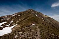
Assuming you start from Abetone Pass, follow the normal route to Monte Rotondo, Libro Aperto's main summit. It reaches the ridge, which you will traverse later to the north-east of the north summit of the mountain. Most likely you will climb across it and scramble up to Monte Rotondo before tackling the traverse.
 |  |  |
Upon returning, simply follow the ridgeline, which heads towards Monte Lagoni. While the eastern side is an uncomplicated slope, the western side drops for about 100m. Here the trail often gets pretty close to the steep western face. After reaching a side summit of Monte Lagoni, the ridge turns wider, later into two paralllel ridges, which head for the main summit of Monte Lagoni. The summit can be very easily reached.
 |  | 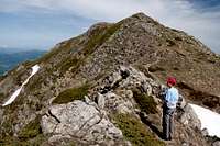 |
Now the ridge turns a bit more in easterly direction, heading for the summit of Monte la Piazza, a round-topped mountain. The ridge consists of a narrow band of greyy sandstone blocks which you have to descend to reach the saddle between the two mountains. Again the ridge widens and a short steep hike leads you to the top of Monte la Piazza.
 |  |  |
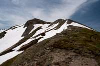
Now the ridge turns eastward and quickly drops towards the next saddle, a wide pass separating Monte la Piazza and Monte Cimone. To reach it the eastern summit of la Piazza needs to be traversed. Once in the saddle you have to tackle the south-west ridge of Monte Cimone, which first ascends a side summit, Il Cimoncino. It is a steep ascent across grass slopes, somehow avoiding the Cimoncino summit, instead passing it in a circle to the west. Here the full ugliness of the Monte Cimone military compound becomes obvious as you slowly traverse along the south ridge towards the buildings on top. No Trespassing signs can be seen anywhere as you hike along the fences. Once on the summit plateau more and older construction awaits you like the chapel and statue for Madonna delle Neve.
 |  |  |
Return the way you came.