
-
 4383 Hits
-
 79.78% Score
-
 11 Votes
|
|
Mountain/Rock |
|---|---|
|
|
44.16554°N / 10.70415°E |
|
|
Hiking, Skiing |
|
|
Spring, Summer, Fall, Winter |
|
|
6437 ft / 1962 m |
|
|
Overview
 Monte Lagoni and Monte Cimone from the south Monte Lagoni and Monte Cimone from the south |
The highest mountain of the Appennino Tosco-Emiliano, Monte Cimone is connected with the rocky Libro Aperto by a beautifully panoramic ridge, one of the most wonderful traverses in the whole range. It consists - together with the endpoints - of four mountains, all among the highest ones of the Appennino in this area but - except for Monte Cimone - still shy of 2000m. Monte Lagoni is among these summits, with 1962m the third highest of them.
While both Monte Cimone (thanks to the road to its summit) and Libro Aperto (thanks to its exposed position close to Abetone Pass) attract quite a lot of visitors, the ridge between them remains solitary for most of the time. The traverse, while definitely an easy one, is long and its endpoints are far from each other with no reasonable means of transport between the two trailheads. Therefore one has to return in ones tracks, a ten hour round trip. Sometimes people are tricked into this traverse because Monte Cimone can look quite close when seen from the other end of the crest. However, its huge bulk is much larger then the rest of the mountain thus leading to this "optical illusion".
 |  |  |
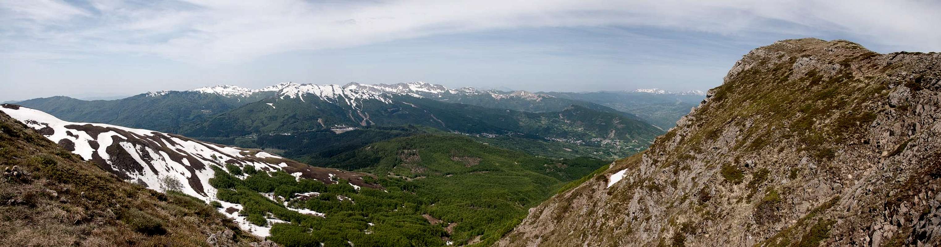
Monte Lagoni is the second mountain after Libro Aperto when seen from the south and an easy trail connects the two mountains. The path runs on ledges high above the steep west face of the crest, always staying very close to the top. Monte Lagoni itself has a round-topped summit, which suddenly drops off with a 200m west face. The east of the mountain is a steep grass slope, which can carry quite a lot of snow until late in Spring. To the north, Monte Lagoni is connected via a rocky ridge to its neighbour Monte la Piazza, a ridge, which reveals the geologic history of the area. It consists of large blocks of grey sandstone, the building material for almost all the high mountains of the Appennino Tosco-Emiliano.
 |  |  |
Summit views include the mountains of the other Appeninno subgroups - Monte Giovo, Monte Prado - Monte Cusna and Corno alle Scale together with the tips of the Alpi Apuane. Naturally - on fine days - you'll be able to sea both of Italy's coasts, the Tyrrhenean one in the west and the Adriatic one in the east. All mountains of the crest can be connected by a ski-tour so that most likely the number of visitors is much higher in winter than in any of the other seasons.
Getting There
  |
Monte Lagoni is often climbed together with Libro Aperto. The hike (or ski tour) starts at Abetone. The pass can be reached as follows from the closest international airports at Bologna, Pisa and Firenze (Florence).
- From Bologna
- Take motorway A1 direction Modena
- At the southern exit of Modena turn onto SS12 south, which will take you all the way to Abetone.
- From Pisa
- Take motorway A11 to Lucca
- Turn onto SS12 north which takes you to Abetone.
- From Firenze
- Take motorway A11 in direction Pisa.
- At the exit Pistoia switch to SS66, direction San Marcello Pistoiese
- At La Lima, behind San Marcello, turn onto SS12 to Abetone
Red Tape
 Crocus Fields near the top of Monte Lagoni
Being located close to the border between Toscana and Emilia Romagna, Monte Lagoni is located at the southern end of the Parco Regionale dell'Alto Appennino Modenese. The usual restrictions for such parks apply. Visit the park's site for more information.
The parking lots at Abetone are charged during the ski season. Having been there outside the season I can't tell the fees. The lots are large and go on for about 1km or more so the approach to the trailhead is the first challenge in winter ;-)
Accommodation
The closest town to Abetone is San Marcello Pistoiese on the Toscana side of the pass. However, you won't find much lodging there. The big cities - Modena and Bologna as well as Firenze and Lucca are about an hour away from the pass so stayying there is a definite possibility.If you want to stay closer you can make use of Agriturismo, holiday farms, which offer rooms, apartments and food. Good places are somewhat hard to find if you don't speak Italian. The site of the Parco Regionale dell'Alto Appennino Modenese has a listing here:
Lodging inParco Regionale dell'Alto Appennino Modenese
Weather Conditions
Maps & Books
Let me know if you know more books or better maps. This is the set I used.Maps
I have not been able to find detailed maps of this area so the following one is a road map, scaled 1:150000
- Tuscanny - Florence
Freytag & Berndt
1:150000
ISBN: 978-3-7079-0281-5
Maps Online
Books
- Tuscany North / Toskana Nord
Wolfgang Heitzmann / Renate Gabriel (translation: Gill Round)
Rother Verlag
ISBN: 978-3-7633-4812-1 (English)
ISBN: 978-3-7633-4115-3 (German)