
-
 18366 Hits
-
 83.1% Score
-
 16 Votes
|
|
Mountain/Rock |
|---|---|
|
|
38.22370°N / 78.7506°W |
|
|
Hiking |
|
|
Spring, Summer, Fall, Winter |
|
|
3374 ft / 1028 m |
|
|
Overview

The second-highest peak in Shenandoah National Park's South District, Trayfoot Mountain is seen by many from the summit of Blackrock but visited by far fewer. Although it is no park secret and is not a long or hard hike from Skyline Drive, Trayfoot has escaped becoming one of the park's overtrodden summits. The most likely reasons for that are probably its being in the less-crowded South District and its being beyond Blackrock, the summit rocks and views of which are sufficient for most hikers and very easy to reach. The trail over Trayfoot Mountain passes through some of Shenandoah's most remote territory, and on an autumn day, fallen leaves can cover the trail so well that only the blazes on the trees indicate the correct way through them.
Trayfoot Mountain has two principal summits, a northern and southern one, with the northern one being the higher of the two. One of the highlights of the mountain is the mile-long (approximately), almost-level ridge connecting the two main summits. Trees hinder unobstructed views and may frustrate photographers, but casual hikers will find the forest open enough to enjoy the high perspective of the rocky slopes of Blackrock and the remote, sometimes-trailless peaks of the South District.
The South District is Shenandoah's wildest. Much of it is federally designated wilderness, and many of its trails, especially on the western side, cut into country that shows few signs of human usage beyond the trails themselves, which frequently are only lightly maintained, and the occasional old campsite left over from the days before Leave No Trace ethics took hold in the American backcountry. The peaks may be lower and the waterfalls far fewer than they are in the heavily visited Central and North Districts, but the terrain makes up for it in peace and quiet and wild streams, talus slopes, and cliffs. Sightings of banner species such as the black bear seem more common here, perhaps because the bears tend to avoid the busier trail corridors elsewhere in the park. And of course, the district still has the same spectacular spring wildflowers and fall foliage found in the rest of the park; it even has at least one beloved plant the other districts do not-- the catawba rhododendron, common further south but found in only a few places in Shenandoah, and showing its large purple blooms in early July.


Routes Overview
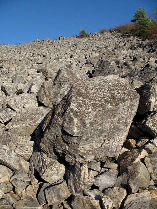
1. Hike from the Blackrock Summit parking area (see Getting There) along the Appalachian Trail or the Trayfoot Mountain Trail for about half a mile to the summit area of Blackrock. A concrete post along the west side of the trails encircling the summit marks the Blackfoot Trail Spur Trail and the way to Trayfoot Mountain and Furnace Mountain. Follow this trail through a Shenandoah rarity-- an open boulder field-- and then downhill to rejoin the Trayfoot Mountain Trail, where you turn right (going left for a couple minutes take you to the base of the talus slopes of Blackrock-- don't pass this up on the way back if you'd like a little Class 2+ over terrain that gets about as close to Western as anything in Shenandoah does). The trail now heads uphill to a junction where Furnace Mountain Trail goes right and Trayfoot Mountain goes left; this point is about 1.3 miles from the parking area. Head left on the trail, which is at first the remains of an old fire road but soon narrows, and follow it up a moderately steep grade for about 0.2 miles to a concrete post marking the summit of Trayfoot Mountain. The actual summit is in the woods a bit to the left. There are no unobstructed views there, but peakbagging purists may want to tap it nevertheless. There used to be a fire lookout there, but all signs of it are gone except for a vanishing clearing. Beyond the post, Trayfoot Mountain Trail continues for 3.8 miles deep into Shenandoah's wilderness to the Paine Run Trail, which leads 0.3 miles west to the park boundary.
One-way distance to the summit is 1.5 miles with 625' of elevation gain.

2. From outside the park, hike the Paine Run Trail for 0.3 miles to its intersection with Trayfoot Mountain Trail and then follow that trail for 3.8 miles to the summit. This way doesn't make much sense if the summit is your principal objective, but if solitude and wilderness are important to you, this is a nice way to go. It also avoids the Blackrock crowds.
One-way distance to the summit is 4.1 miles with around 2000' of elevation gain.

3. From CheesySciFi: "Another route to the summit is the Furnace Mountain Trail. The round trip is about 7.5 miles with an elevation gain of about 2000 feet. The one-way trip is 3.6 miles on the Furnace Mountain Trail, 0.2 miles on the Trayfoot Mountain Trail, and between 0.1 and 0.2 miles on a fire road. Add another mile and 250 feet of elevation gain if you make a side trip to the summit of Furnace Mountain."
Keep an eye out for copperheads, timber rattlesnakes, and poison ivy. Late spring through summer, carry insect repellent or prepare to swat and/or itch a lot.

Getting There
Drive into Shenandoah National Park at any of the four entrances to Skyline Drive. Drive to a parking area about 0.3 miles north of MP 85 (miles are marked in ascending order from north to south). This is the Blackrock Summit parking area and the trailhead. A sign provides a diagram of nearby trails and suggestions for hikes. This is the way to access the first route described above.To access the second route, turn east onto SR 661 from U.S. 340 just south of Grottoes in the Shenandoah Valley. Parking is available at a turnaround where state maintenance ends. You must hike up the now-private road to reach the lower end of Paine Run Trail. Please respect the landowners' property so that they will continue to allow public access.
Access to the third route is from the end of SR 659, which heads east from U.S. 340 a little north of Grottoes. Please respect private property here.

Red Tape
It costs $15 to enter the park, and that provides access for a week. Annual passes cost $30. The interagency pass, good for yearlong entry to areas managed by NPS, USDA Forest Service, USFWS, BLM, and the Bureau of Reclamation, costs $80.The park is open all year, but Skyline Drive does sometimes close after snow or ice storms. The park site does not give current road conditions, so call ahead (540-999-3500).
To reduce poaching, Skyline Drive is subject to closures during hunting season. The information below, copied and pasted from the park site, illustrates the 2006 restrictions—
From November 13, 2006, through January 6, 2007
Skyline Drive
• between Front Royal (Mile 0 at U.S. Highway 340) and Thornton Gap (Mile 31 at U.S. Highway 211), and
• between Swift Run Gap (Mile 65 at U.S. Highway 33) and Rockfish Gap (Mile 105 at U.S. Highway 250),
will be closed daily between 5:00 p.m. and 8:00 a.m.
The central portion of the Drive, between Thornton Gap and Swift Run Gap, will remain open for overnight access to Skyland Resort and Big Meadows Campground until those facilities close on November 26.
Then, beginning November 27, 2006, through January 6, 2007, the entire length of the Skyline Drive will be closed daily from 5:00 p.m. until 8:00 a.m.
Specific information about the dates for the current year is available on the park's website.
Camping
The closest campground is Loft Mountain, which has showers, water, flush toilets, and a store. The access road for the campground is at MP 79.5. The campground is open from mid-May through October, and you can make reservations to stay there, though only 10% of the sites are reservable (see park link for more details). It is the park’s largest campground, but it will usually fill on holiday and October weekends. The fee for a campsite is $15 per night (as of 2007, higher if you reserve).Backcountry camping requires a free permit available by self-registration at entrance stations.

External Links
Official park siteCamping info
Lodging info