
-
 20357 Hits
-
 81.18% Score
-
 13 Votes
|
|
Mountain/Rock |
|---|---|
|
|
38.47910°N / 78.4159°W |
|
|
Madison |
|
|
3845 ft / 1172 m |
|
|
Overview
Fork Mountain ranks as the third highest peak in the Blue Ridge Mountains north of Charlottesville. It is also the highest peak in the Rapidan Wildlife Management Area, which is on the border of Shenandoah National Park. Parts of Fork Mountain are in Shenandoah National Park, but because the summit is not, Hazeltop is actually the third highest peak in the park.Although the summit of Fork Mountain is not all that much to write home about (it is wooded and has an antenna farm), it is still a worthwhile hike. Depending on your route to the summit, it is possible to gain nearly 3,000 feet in elevation or see a waterfall and the historical Rapidan Camp that was built by President Herbert Hoover and served as a retreat throughout his administration.
It is also possible to stay at a cabin near one of the trails to Fork Mountain that is rich in historical significance. In the early 20th Century, the Jones Mountain Cabin was the home of Harvey Nichols, who was a locally famous moonshiner. After the federal Government bought out all of the property in what is now Shenandoah National Park, it burned down most of the houses of the former landownders. Somehow, the Jones Mountain Cabin was forgotten until it was rediscovered in the 1960s. It was renovated by the Potomac Appalachian Trail Club and is now a popular place for hikers to spend a night or two.
Getting There
Graves Mill Trailhead: From Culpeper, go south on U.S. 29 for about 20 miles. South of Madison, turn right at Route 230 West. Follow Route 230 for about four miles to Wolfton. Turn right at SR 662 and follow it to its end at the Shenandoah National Park boundary.Dismount your vehicle in the parking lot and hike for 0.5 miles on the Graves Mill Trail. Turn left at the Staunton River Trail and follow it for 4.1 miles. Turn left at the Fork Mountain Road and follow it for 0.8 miles to the trail junction at The Sag. Continue on the road for about another 0.8 miles to the summit. The true summit is a rock with a few small trees growing out of it in between some of the antennas.
Round trip: About 12.4 miles with an elevation gain of more than 2,900 feet.
 |  |  |
Fork Mountain Road: From Culpeper, go south on U.S. 29 until reaching Route 231. Go north on 231 and then turn left on SR 670 towards Syria. Make another left on SR 649 and follow it to its end. SR 649 becomes Rapidan Road as its enters Shenandoah National Park. Follow Rapidan Road until just before the first bridge across the Rapidan River, which forms the boundary of Shenandoah National Park and the Rapidan Wildlife Management Area. Parking is available off the road.
Walk across the bridge. After about 50 feet beyond the bridge, reach a fork in the road and bear to the left. This is the Fork Mountain Road, which you will follow all the way to its end at the summit. The road makes a modest and unbroken ascent over the next 4.4 to 4.5 miles. Although the road is open to vehicles over the first 1.8 miles to the gate at the boundary with Shenandoah National Park, your hike is unlikely to be disturbed very much. Limited views of Jones Mountain, Doubletop Mountain, and Fork Mountain and its subpeak are available.
Round trip: About 9 miles with an elevation gain of 2,200 feet.
Rapidan Road: From Culpeper, go south on U.S. 29 until reaching Route 231. Go north on 231 and then turn left on SR 670 towards Syria. Make another left on SR 649 and follow it to its end. SR 649 becomes Rapidan Road as its enters Shenandoah National Park. Continue through the park and the Rapidan Wildlife Management Area until reaching a gate where the road re-enters the park. Leave your car here.
Hike upwards on the Rapidan Road for about 0.5 miles. Bear left at the fork in the road and continue on the Rapidan Camp Road for 0.8 miles to the Rapidan Camp. Take the Mill Prong Trail to the right if you want to make a short side trip to Big Rock Falls. Take the Laurel Prong Trail if you want to go directly to the summit. After 0.6 miles on the Laurel Prong Trail, Make another left on the Fork Mountain Trail and follow it for 1.3 miles to The Sag. Turn left on the Fork Mountain Road and reach the summit after about 0.8 miles.
Round trip: About 8 miles with an elevation gain of 1,600 feet.
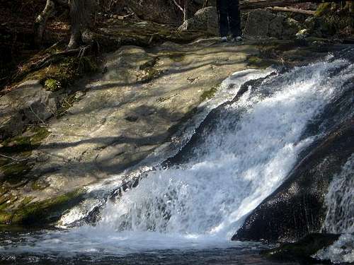 Big Rock Falls
Red Tape
Entry to Shenandoah National Park is free from the boundary. The $15 entry fee is only applicable if you come in via Skyline Drive.When to Climb
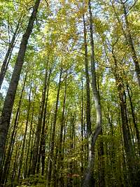
Fork Mountain can be climbed nearly all year round. The hike can be particularly delightful in mid to late October when fall colors are at their peak; many trees below 3,000 feet elevation still have their leaves on Veterans Day. It is recommended to avoid hiking in the Rapidan Wildlife Management Area, which includes the summit of Fork Mountain, from mid-November to New Year's Day because deer hunting with modern firearms is permitted. Summer is the worst time for mosquitoes, ticks, and other hostile little critters. The heat and humidity are also at their worst in summer.The Rapidan Road is a well-maintained gravel road until it reaches the first bridge over the Rapidan River. Once you cross the bridge into the Rapidan Wildlife Management Area, driving can become dicey, particularly in the winter or if you have a low clearance car. Be aware of road conditions in advance. You NEVER want to hear the sound of rock on metal even if your vehicle escapes undamaged!
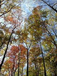
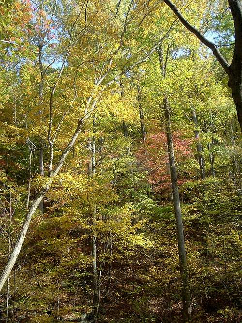 Fall Colors
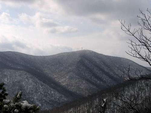 Fork Mountain from Doubletop
Camping
The Jones Mountain Cabin can accommodate as many as 10 guests. To reach the Jones Mountain Cabin, hike for 2.2 miles on the Staunton River Trail from the junction with the Graves Mill Trail. Turn left at the Jones Mountain Trail and follow it for 0.7 miles. Make another left on a side trail and follow it for 0.3 miles to the cabin. Contact the Potomac Appalachian Trail Club for more information.Free camping is permitted throughout the Rapidan Wildlife Management Area for up to 14 consecutive days. There are numerous campsites near the Rapidan Road.
Free backcountry camping is allowed throughout Shenandoah National Park. The required permit can be obtained through mail or at entrance stations, park headquarters, or visitor centers. Campfires are only permitted at pre-constructed fireplaces at backcountry huts and day-use shelters. Campsites must be at least:
•10 yards away from a stream or other natural water source.
•50 yards away from standing buildings and ruins.
•100 yards away from a hut, cabin, or day-use shelter.
•1/4 of a mile away from a paved road or park boundary.
•1/2 of a mile away from Hoover's Rapidan Camp.
Rapidan Camps (not to be confused with Hoover's Rapidan Camp in Shenandoah National Park) rents out cabins near Rapidan Road in the Wildlife Management Area after the second bridge. It is identified on the USGS topographic maps as "Rapidan Family Camp".
 Jones Mountain Cabin
External Links
Shenandoah National ParkRapidan Wildlife Management Area
The Potomac Appalachian Trail Club rents the Jones Mountain Cabin, maintains the trails in the Shenandoah National Park, and provides maps, guidebooks, and other information.
Rapidan Camps rents cabins and gives reports on the condition of the Rapidan Road.