Trek Along Ancient Frontier Recently Painted Blue And Yellow
Warning: Not for those who seek mountain tranquility free of man-related trouble
Dedicated to all those who seek their spiritual home within the Carpathian arc
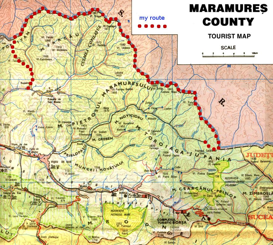
![The traverse of RO/UA border]() The traverse starts
The traverse startsDay 1
Valea Vişeului – Vişeu de Sus – Vaser Valley - Hnitessa/Ignăteasa
My most adventurous trip through the Marmarosh Mountains happened to take place last October when finally, after a few visits to the area, I made a traverse across the heart of this remote mountain range which rises on the eastern outskirts of Central Europe. The actual start of the adventure took the form of midnight negotiations with the Romanian border police at Valea Vişeului, and the route I would follow was the border line separating Romania from Ukraine.
I was given a permit to get as close as 20 meters to the border corridor, also known as the
Forbidden Zone. The same procedure was repeated at Vişeu de Sus at about 4 a.m. Thanks to a pretty friendly attitude of the Romanian officers, I felt like I really was able to carry out my plan, like my old dream was coming true in the end. The dream plan was to complete a 60 km trek along the border: From the legendary summit of
Hnitessa/Ignăteasa in the southeast to
Pop (Pip) Ivan Maramaroskyi near the other end of the Marmarosh Mountains, their second highest peak as well as the most spectacular mountain massif.
Departing at 7 a.m. from Vişeu de Sus, the freight train was the only option for me to quickly approach the Romania-Ukraine border. A forest worker helped me to find the train, because it departs about 200 meters away from the railroad station at Vişeu de Sus. On the train, I was accompanied by a trio of German tourists and a Slovak TV reporter along with his three Polish workmates. The temperature was well below zero, but none of us minded as we were all enthralled by our journey on the last operating narrow-gauged forest railroad in Europe!
As soon as our train left the station, we got enchanted by the fabulous scenery of the valley of the Vaser River. All of a sudden, the train came to a halt: A haystack needed to be taken. I decided to move to the last carriage and carry on travelling with the local guys. It was the best place on the train to better capture the beautiful fall colors of the mixed, mostly beech and spruce, forests covering the slopes of the valley. The lower, shady parts were in stark contrast with the tree crowns basking in morning sunshine. Also, I was amazed by the length of the train, which unraveled before our eyes as we passed innumerable bends in the railroad and crossed the shaky bridges. When we arrived at the
Paltinu stop, the last carriage had to be disconnected and I returned to the passenger carriage. I managed to open the window and continued filming the romantic scenery of the wild parts - previously unknown to me - of the "Valley of the Water". My attention was focused on the most attractive section which was made up of a deep rocky canyon with three tunnels and bridges. The Slovak TV reporter decided to move to the locomotive to get better views.
![A haystack to travel by rail]() Haystack to travel by rail Haystack to travel by rail |
![The freight train]() The train The train |
![The first tunnel]() Wow! Wow! |
We arrived at a significant stop called
Făina, where we spent some time waiting till some of the carriages got disconnected. From the train we could see a small wooden church, which was built by the German-speaking settlers and was dedicated to Empress Elisabeth, also known as
Sisi. A painting of a brown bear indicated that we had entered the remotest parts of the Vaser Valley. The passenger carriage was getting more and more empty, but some new people had got in, among them the railroad worker speaking Russian and Rusyn as well, with whom the TV reporter decided to make an exclusive interview. Near the
Măcârlău stop the results of recent years' summer floods were clearly seen. The valley was getting narrower and narrower: The
Valea Babei stop. I thought this was the end of our journey, but the forest worker speaking with a distinct Rusyn accent told me that the train would go on running after a short pause, as far as
Cataramei, on 42 km from Vişeu de Sus. There I said good-bye to all of my fellow-passengers and set out on what was to be the longest trip I have ever made.
![Significant stop called Făina]() A stop named Făina A stop named Făina |
![The result of recent years’ summer floods]() Floods take their toll Floods take their toll |
![POLITIA DE FRONTIERA]() Frontier post Frontier post |
encounter with a frontier guard – he says my permit is OK! I am allowed to carry on. Another kilometer and
another inspection – this time by three border police officers. Then I go on trudging through the upper parts of the Vaser River. The railroad is badly damaged owing to the flash floods of 2008. I see a notice that reads: POLITIA DE FRONTIERA! I am greeted by two barking dogs and my papers are checked for
the third time. Then I am advised to make use of the old shelter at the foot of Hnitessa's summit. One of the soldiers who speaks English draws a sketch map for me and I am encouraged to spend the night in this abandoned military object. I reach the spot after about an hour, to see a ruined cabin which remembers the communist era. But my desire to reach Hnitessa is too strong to stop now.
![The sentimental crag of Hnitessa peak]() Crag of Polish dreams Crag of Polish dreams |
![Hnitessa/Ignăteasa ridge (1766m)]() Nearing Hnitessa's summit Nearing Hnitessa's summit |
![Border summit of Ignăteasa/Hnitessa]() Top of legendary Hnitessa Top of legendary Hnitessa |
When ascending the mountain through the dense coniferous forest which covers its slopes, I lose my way so I decide to continue along the forest road crisscrossed by rills of rushing rain water.
Suddenly, I can see the crag of my dreams - the top of the legendary Hnitessa! I try to use a shortcut to reach the elusive summit but it turns out to be the wrong idea. The forest road vanishes from under my feet, giving way to a steep ascent through an evergreen forest. But this is just the beginning of trouble. Soon I get stuck in the middle of a thicket of the dwarf pine which forms the green, living, hardly passable walls around the historic summit. The seemingly never-ending passage makes me totally exhausted. When I finally spot a Ukrainian border signpost, the trickles of sweat running down my cheeks get reinforced by a couple of tears. Only after such an arduous ascent can I speak to myself, in my right senses: "Well, I hope her majesty Hnitessa recognizes I am the right man in the right place, at the right time."
For centuries at or near the summit of Hnitessa (Ignăteasa) three countries met: the Polish-Lithuanian Commonwealth, the Kingdom of Hungary and the Principality of Moldavia. No wonder this remote twin-peaked mountain is held in high regard by many trekkers – especially by those who come from Poland.Day 2
Hnitessa/Ignăteasa – Piatra Baltagului – Koman – Ştevioara – Purul – Păcurar
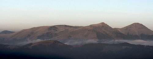
![Rodnei Mountains and Toroiaga group]() Rodnei Mountains and Toroiaga group
Rodnei Mountains and Toroiaga group
An October morning on the top of Hnitessa offered breathtaking panoramas of both Romanian and Ukrainian Carpathians. Thanks to freezing temperatures and an atmospheric inversion, visibility was excellent. At first I was amazed by the scenery of the
Rodnei Mountains on the southern horizon, with the dominant
Ineu and
Pietrosu peaks. But personally, for me the most precious were the views of the significant Marmarosh summits, such as
Jupania (1853m to the south),
Piciorul Caprei (1804m, SW),
Toroiaga (1930m, W),
Pietrosu Bardăului (1850m, NW),
Mihailecu (1918m, NW) and
Farcău (1957m). I've been told that hardly anybody was lucky enough to be able to enjoy such a unique panorama of these remote summits of the Marmarosh Mountains. On the Ukrainian side it was possible to have great views of the
Chornohora and
Bucovina mountains. But my attention was caught by "4 + 1 white domes" sitting on a parallel ridge. I didn't yet know what exactly it was, maybe a former Soviet military base or astronomical observatory, I thought. I stood in the center of a "Forbidden Zone" marked by the Romanian and Ukrainian frontier signposts, and was afraid of being observed by a spyglass of our former "Big brother". A flock of crows flew over the border corridor from Ukraine to Romania without any trouble or permits. If only a man could be so free... Anyway, there is no doubt I will remember that special autumn morn spent on this legendary summit till the end of my days.
![Bucovina Mountains]() Bucovina Mountains
Bucovina Mountains
I visited both summits of Hnitessa – the higher one is formed of a solitary, dominant cliff, from where I saw the Ukrainian military road with broken fences. At midday, I started to trek along the border line. The line of border markers took a turn to northwest and soon I was hiking on the
Palenitsa ridge. I passed a huge lump of excrement, probably a brown bear's – and descended to a saddle. A moderate ascent to
Piatra Baltagului (1733m) followed and I was able to admire the rocky formations located about 1 km from that summit.
A frightened deer escaped into the forest while I was climbing the summit of
Koman/Comanu (1724m), whose name is a kind of memorial to a people called
Cumans. The border line turned to the north as I started to go down the
Ştevioara ridge. This section offered the first views of the imposing mass of
Chyvchyn, which stands on the territory of Ukraine and whose name is often extended onto the eastern half of the main ridge of the Marmarosh Mountains. I climbed
Puru (1617m) and descended to a saddle, where the Ukrainian military road appeared in close proximity to the "Forbidden Zone". And just then for the first time I was beginning to get a little frustrated, because I was not able to
legally set foot on this military road. Moreover, after I had climbed a summit called
Păcurar, there were problems with orientation! According to my map, the border turned northwesterly, but I found it terribly difficult to spot the next border marker. No wonder, it turned out the signposts were damaged, broken and prostrate on the ground, hardly visible through the high grass.
![Five domes in the background]() 4 + 1 white domes 4 + 1 white domes |
![Piatra Baltagului]() Piatra Baltagului Piatra Baltagului |
![Ukrainian military road]() UA military road UA military road |
The border corridor was getting narrower and narrower, and after half a kilometer I found myself trapped by dwarf (mugo) pine bushes – again! I hesitated, pondering whether that was the right path, and finally made the decision to keep on plodding through the elfin thicket. That appeared to be a good choice as, in a short while, I came to another couple of border posts. An arduous descent followed - through high grass, over and around fallen trees - while the Ukrainian road ran just 20 meters away. But I didn't want to make the fatal mistake of being detained by their frontier guards. I remembered the warning in my Czech guidebook: UNDER NO CIRCUMSTANCES SHOULD YOU CROSS THE BORDERLINE! I also remembered stories from the communist era about groups of Czechoslovak trekkers approaching the border through Romania who were enticed to cross the border by the Soviet border police, then immediately detained. I don't know whether or not they got imprisoned, but such a fatal mistake must have brought their trek to a premature end. Having those tales on my mind, I kept focusing on my goal, which was to successfully traverse the border corridor.
Day 3
Păcurar – Lostunu Mic – Lostun – Şuligu
I went on walking along the border corridor, ascending, and things were much like the evening before. I came to an old trench about 100 meters long – probably a remnant of one of the two world wars. Then I was lucky to observe a female roe deer with a couple of calves. They were coming from Romania and crossed the borderline, running into Ukraine. Another example of no barrier for non-human creatures. That's a shame a man cannot roam free like that! The line of the border signposts pointed north, toward
Muntele Lostun rising one km away from the "Forbidden Zone", on Ukraine's territory. There were great views of Chyvchyn in Ukraine as well as the Toroiaga group in Romania. A male capercaillie got a fright on seeing me when I was nearing a broad saddle. I found this abandoned zone with spruce trees and berries the best habitat for this species, which loves peace and quiet. I trekked across a mountain pasture, skirting the main ridge, before I reached a small tarn called Lostun. There is strong evidence of the tiny wetland ecosystems gradually disappearing from the Marmarosh Mountains. After a tedious ascent I stood on the top of
Lostun (1640m), from where there were picturesque views of the Chornohora and Hryniava mountains situated on the Ukrainian side. Also the vistas of Pietrosu Bardăului were impressive.
![Hryniava mountains]() Hryniava Mountains
Hryniava Mountains
Suddenly I looked up at the sky and I saw a raven which was being tormented by a lesser-spotted eagle. Having turned at a right angle, walking down the northwestern slope of Lostun, I heard a red deer stag roar in the forest at a distance of about a hundred meters. I descended to the nearest source of water, because it is very hard to find water near the main crest. A difficult ascent to the
Şuligu peak and for the first time I decided to set foot on the Ukrainian road, recognizing an impassable thicket of juniper bushes in the border corridor. I took a shot of the photogenic, outstanding
Chyvchyn (1767m) with a blue and yellow Ukrainian post in front, and admired a panorama of the Chornohora with Hoverla, the highest peak of Ukraine. A black grouse flew by, unable to escape the lens of my camcorder though. It sat down on a spruce log. I managed to get as close as 20 meters to this rare bird – a good catch. Past Şuligu, I was pleased to see a romantic mountain meadow which looked like an ideal site to pitch my tent.
![Toroiaga summit (1930m)]() Toroiaga (1930m) Toroiaga (1930m) |
![Ancient border line]() Forbidden Zone Forbidden Zone |
![Chyvchyn massif (1765m)]() Chyvchyn (1767m) Chyvchyn (1767m) |
Day 4
Suligul – Chyvchynazh – Lutoasa
The rays of the morning sun lured me out of my tent. The first thing I did was photographing
Pietrosu Bardăului, at 1850m one of the major massifs of the Marmarosh Mountains, basking in the sunshine. I went a hundred meters down the slope to fill in my water bottles at the nearest spring. More splendid morning views, like those of the cliffs on the southwestern flank of Şuligu and of the side spurs branching off the main crest. I returned to my destiny lined with the concrete border markers painted blue and yellow and said goodbye to Şuligu.
![Pietrosu Bardăului summit (1850m)]() Pietrosu Bardăului (RO) Pietrosu Bardăului (RO) |
![The cliffs of Şuligu (1688m)]() Crags of Suligul (UA/RO) Crags of Suligul (UA/RO) |
![Vistas of the Chornohora]() Chornohora (UA) Chornohora (UA) |
The next section of the border didn't follow the crest but dropped 20 meters down the west, steep side of
Chyvchynazh. A classic illustration of the greed of the Soviet regime, I thought. I saw another capercaillie and after several ups and downs entered a mosaic of mountain meadows dotted with spruce trees. Although the border posts climbed the steep slopes of
Budescu, I decided to traverse it so as to reach the little tarn of Lutoasa. But I found only high grass in the saddle, where I put up my tent and made a fire.
Day 5
Budiyevska Velka/Budescu – Ledyeskul/Ledescu – Kopylash/Copilaşu
![Autumn sunrise]() The heart of the Carpathians
The heart of the Carpathians
Before sunrise I tried to record the gradual illumination of the Farcau-Mihailecu massif rising to the northwest and the Toroiaga group in the southwest. Then I tucked my frozen tent in my backpack and off I went again. Having parted with the summit of
Budescu, I could finally hurray – it was the first time I had followed a Romanian road, overgrown by low grass.
The border corridor from Hnitessa to Budescu summits had been really hard to pass – you stumble and stagger constantly as there is anything but a path on the Romanian side of the border line!
![Autumn panorama of conspicuous massif]() Mihailecu - Farcău massif
Mihailecu - Farcău massif
While I was descending toward the saddle, I scanned with my eyes what was ahead of me. The main crest looked a bit like a rolling upland. The forest teemed with birds and all the time I could observe interesting bird species, at least another black grouse or crossbill. The scenery of the broad-leaved forest, so colorful in the fall, was simply fabulous. My Romanian grassy road skirted the "Forbidden Zone" at a distance of 10-20 meters, which went fairly well with my permit letting me approach "no closer than 20 meters". Then the line of border posts turned northwesterly to traverse the gentle slope of
Ledescu, with a wooden shelter on its west side. The roads on both sides of the border were getting wider and the probability of meeting the police had risen considerably. Then the borderline turned northeastward and the Romanian road parted with it, skirting the ridge of
Furatik from the northwest. Another forest animal got scared by my presence, another kilometer of traverse through the forest and I found myself above the tree line.
![Stih/Stogu (1650m) on the horizon]() Stih/Stogu/Stóg on horizon Stih/Stogu/Stóg on horizon |
![RO/UA Forbidden Zone]() Rolling Rolling |
![Wooden shelter of frontier guards]() Border line & markers Border line & markers |
Unexpectedly, a tall watch tower rose ahead of me, some 200 meters into the Ukrainian chunk. The nearby iron gate was closed but I felt like I was being carefully followed by someone's binoculars since I knew I was in what was part of the Zelene (Shibeni) military base. During my ascent up the east slope of
Copilaşu, I caught sight of three human silhouettes, on the Romanian side of the border. I wondered what could happen the next time I was stopped, which was to happen very soon. One of the Romanian officers spoke with a Rusyn accent, which Im familiar with. There was no difficulty communicating and my permit worked very well. To my surprise, I was given a fresh loaf of bread and was told to make a fire and spend the night in the wooden shelter situated just five meters off the borderline.
Day 6
Radieskul - Stih/Stogu – Korbul – Shchavul – Mica Mare
What wakes me up turns out to be the voice of a Ukrainian border police officer who has crossed the border line and is checking my passport. "Why's there no stamp of the Sighetu Marmatiei border crossing point?" "Because we are inside the EU zone," I say in Ukrainian.
He wonders where I am coming from. I show him my route on my map made by the army's cartographers from Kiyv, and then he starts to suspect me of making use of their military road. "Be sure we'll check that there are no footprints you've left in the mud on our road." I get terrified. Then he moves a few steps back, into the "Forbidden Zone" and stands there, in the center of the corridor, waiting for me to hand him my permit. I realize I mustn't follow him. That would be the FATAL MISTAKE. "I'm not gonna bust you," he says. I flip him my Romanian permit typed in English and translated into Ukrainian. He stares at it for a minute, then he is gone.
(NB The Ukrainian frontier guards are not permitted to cross the border of the European Union.)
![The top of Stih/Stogu]() The top of Stih The top of Stih |
![Former triplex of Stih summit]() Dear to CZ/PL/RO hikers Dear to CZ/PL/RO hikers |
![Historic border post on the top of Stih/Stogu summit]() The historic signpost The historic signpost |
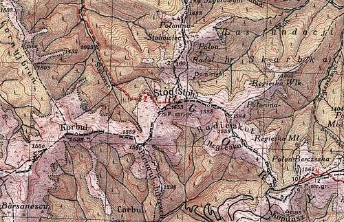
So far I have been very lucky to enjoy favorable weather conditions for five consecutive sunny days. But today, the weather is getting worse with a frontal, low pressure system in sight. I ascend the summit of
Radieskul/Reheska, then I head for another historic summit on the main ridge of the Marmarosh Mountains. Between the first and second world wars
Stih – then
Stoh/Stóg/Stogu – was the point where another trio of countries met: Czechoslovakia, Poland and Romania. While for Polish hikers reaching both Stóg and Hnitessa summits is a must, the Czechs and Slovaks just have to climb Stoh to relive the old days when that summit was the southeasternmost point of the first Czechoslovak Republic. I climb the historic triplex before noon. An obligatory summit photo is taken of myself, posing right in the middle of the "Forbidden Zone" on the old, lower and sturdier concrete post, some two meters away from the Romanian one. I spent half an hour on the top of this historic summit, trying to imagine what an incredible SP meeting it would be if my fellow SP'ers, Carpathian friends, could join me here:
Andreea approaching from the south,
Jacek – coming from beyond the Chornohora, the next mountain range to the north, where his parents lived before the 2nd war, and
Peter from across the Great Hungarian plain...
![E Carpathian T-junction, 1938]() 1930's triplex
1930's triplex
After descending the steep west face of Stoh, completely covered by spruce woodland, I climb
Kurbul. At the saddle, I replenish my water bottle. I already feel pretty weary so I decide to follow the Ukrainian road again when climbing the
Schavul/Shaul ridge. Up and down, up and down, and I set foot on
Neněska, at 1820m the third highest mountain massif on the main ridge of the Marmarosh Mountains. It is three months since I looked at Neněska, or Mica Mare (Romanian name), from a spot just two miles to the south where I pitched my tent after climbing
Farcău, the highest summit in the Marmarosh Mountains. Now visibility is very poor, only a dozen meters – thick fog – no views of Farcău at all.
![a notice board]() Crossing forbidden Crossing forbidden |
![Mica Mare (1815m)]() Nyeniska/Mica Mare Nyeniska/Mica Mare |
![Signpost in the border zone]() Trail signs in UA Trail signs in UA |
On the crag on Neněska's north face climbing gets a bit tricky, I am having difficulty keeping balance on the slippery rock. I spot yellow marks and continue along with them and the barbed wire of the communist era, slowly losing elevation. The scenery makes me think about the Czech naturalist,
MILOSLAV NEVRLÝ who wrote about this trek through the heart of the Marmarosh Mountains in his
Carpathian Games – recently translated to Romanian as Jocuri Carpatice: "...on several stretches, there are five fences."
The times they're a-changin', I keep returning to the thought. Then there is a notice board: Warning: Ukraine's state border – crossing forbidden! To my surprise, there are trail markers written in both Cyrillic and Latin. I decide to leave the Ukrainian road and cross the border into Romania. I pitch my tent just one meter off the border marker.
Day 7
Bendriaska – Holovac – Capul Groşilor – Tomnatec – Repedea
The cloudy morning makes me feel like finishing my frontier trek. I come to the saddle at the east end of the massif of
Pop Ivan where I meet a solitary Ukrainian hiker heading to the summit. Having climbed Pop Ivan before, I do not follow him. Skirting the southeast face of
Capul Groşilor, I
pick a sheep track leading to the 1618m
Tomnatec. There I find the trail waymarked with yellow stripes. Enjoying the romantic fall colors of deciduous forest as well as watching a playful black squirrel, I descend toward the village of Repedea down in the Ruscova Valley.


Comments
Post a Comment