Overview
While this trip report is posted under Bald Mountain, it really isn't about Bald Mountain. Bald Mountain has a trail to the top which is not a bad thing but the interesting aspect of Bald mountain to me is the proximity it has to the high point of Wasatch county, which is across the road from it. One of the things I like to do is hike or climb the county highpoints of a state and Utah has 29 of them, all outlined in a fine book titled "High in Utah". No drugs involved here, just the high one gets as one gets as high on the mountain as one can get.
Update:Today there is now a SP page for both Murdock Mountain and Mt. Cardwell and since the Wasatch county highpoint sits on the flank of Murdock and very near Cardwell, it is appropriate to note that in the future I will use these three, Bald Mt, Murdock Mtn. and Mt. Cardwell to "show and tell" about this county highpoint.
I recently did the hike to the summit of Bald Mtn. and enjoyed a different viewpoint of where the county highpoint is located. I recommend the hike up Bald Mountain highly and you could combine it with a hike of Murdock Mtn as well as visit the county highpoint.
Neighboring Duchesne county has King's Peak as it's county highpoint (also the Utah State highpoint) but Wasatch county isn't so lucky. Its county highpoint is found on the flank of Murdock Mtn as shown on the map shown in the signature picture slot above. Click on it to get highest resolution and the detail needed.
It isn't an easy spot to find, it takes some work to find the exact highest point and a GPS comes in mighty handy for this one. What you have to realize is that most of Utah's county highpoints are found at the tip top of mountains like Mt. Nebo, King's Peak, Ibapah, Mt. Peale, etc but a couple are not so clear cut and are referred to as "liners". This is what the HP of Wasatch is, a liner.
Armed with the trip reports and GPS coordinates of others who had preceeded me, I ended up driving to a spot below Bald Mountain overlook (I parked my car at (40.68418° N, 110.90290° W nad 27). This is highway 150, an excellent road . My Honda parked quietly on the north side of it.
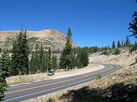
![Murdock Mtn]() Terrain of cohp area
Terrain of cohp area
I headed Southeast across the road and started up the hill, using my GPS as my guide. A little cross country effort of maybe 15 minutes found me soon in the correct area (lots of rock and talus) and I began my search for the HP. I quickly ruled out some of the Topozone co-ordinates I had and used the directions given by
Edward Earl in his report. I saw several cairns in the area but all but two seemed off the mark (in my opinion of course). A large one to the north was actually a bit out of the area and I GPS'd each one and have listed them below. The two pics below show the big one that is in Duchesne county and the one that is fairly close to the highpoint.
Two of the closest were rather interesting. One simply consisted of about 16 stones placed in an arch shape and the other was on top of a rock with a good view of a pretty lake down below. This was the cairn put up by Gerry and Jennifer Roach along with Dave Covill and it came complete with a small pill bottle register. In my searching for the true HP, I felt it was close to these two mentioned cairns (see below). The closest one to the correct spot in my opinion was the large cairn put up by Gerry and Jennifer Roach and Dave Covill. I found the small pill bottle with its register and found three entries which were:
08-24-02 - Gerry & Jennifer Roach and Dave Covill
07-03-03 - Ken Akerman (his 18th Utah cohp)
09-29-03 - T-bone and the Sherpa (yup, I'm not making this up)
The pics below show the cairn put up by the Roach's and Covill team and include a couple of the register pages that were inside the pill bottle type register.
I signed in below good ole "T-Bone". (not shown)
So, the spot that I felt was highest and still within Wasatch county is listed below:
40.6788 -110.9013 NAD27
I took the following GPS-derived coordinates for the cairns found there:
(40.67844° N, 110.90164° W) - the Roach / Covill cairn
(40.67883° N, 110.90165° W) - 16 Stone cairn
(40.68113° N, 110.90034° W) - large cairn to north
(40.68031° N, 110.90168° W) - small cairn
All the while I was searching and stumbling around this talus riddled area, Bald Mtn was a dominating presence as
this pic shows. After I had satisfied myself, I headed back for the car and to where I was staying in Park City. As I drove back over highway 150, I began to realize the beauty of this area and need to get back up there to really do some exploring. I had had quite a wonderful week in Utah. Bull Mtn, Flat Top Mtn, Ibapah Peak, Deseret Peak and Mt. Nebo had all let me trod on their summits. Yet, in a curious way, finding the HP of Wasatch county was perhaps the most satisfying accomplishment of them all. You actually have to think a lot in trying to locate the elusive and somewhat mysterious
HP.


Comments
Post a Comment