Introduction
Brad's Outdoor Adventures
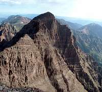
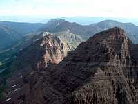
Maroon Peak (14,156 ft), N. Maroon Peak (14,014 ft)
South to North traverse
Class 4+
Distance (round-trip): 9.4 miles
Elevation gain: 4,850 feet
My time in Colorado is coming to an end, so before leaving I’ve decided to make it a point to visit a few key mountains I have been meaning to get to. The world-famous Maroon Bells have captivated me since I first laid eyes on a picture of them taken from Maroon Lake. I wondered what it would be like to view the world from their lofty summit perches. During my time in Colorado, I have planned to climb them many times, but every trip was canceled for one reason or another.
So, when Thursday opened up unexpectedly for me, I decided to attempt the traverse solo. I have read this is not a wise decision due to route-finding difficulties, but after poring over maps, route descriptions, pictures and trip reports, I was confident I could find my way. I parked at the trailhead at eight o’clock Wednesday night, surprised at how chilly the August air had become.
Route Photos (also linked throughout the text):Maroon Peak Ascent
I was on the trail by 3:30 in the morning. The approach felt long in the dark, but it was on a good trail the whole way. I turned off my head-lamp as I started up the side trail to Maroon Peak at 5:15. It did not take long to get a feel for how steep the next 2,800 feet would be. The trail was easy to follow up the grassy slopes leading to rocky cliffs above, but it was steep! I felt good once I found my rhythm, but even so I had to stop several times just to catch my breath. And did I mention how steep it was?
A few hundred feet below the ridge crest, the grass and wild-flowers were
replaced by crumbly rock. Still, it was easy to follow the path of least resistance on the talus and scree all the way up to the notch at the south ridge.
From here I followed a well-cairned ledge below Point 13,753. The trail was nice, leading the whole way to the two gullies where you can take your pick. I chose
the first gully, and avoided most of the loose rock by climbing the solid stuff on its right side. It was not bad at all, though there was enough loose rock I would have only taken it one person at a time had I been in a group. Halfway up the gully, I regained the
well-cairned ledge-trail and continued following it up and down the rest of the way to the couloir between Point 13,753 and Maroon Peak.
This couloir consisted of an annoying slog up loose, deep scree; it was almost like trying to walk up a slope of quicksand. A better option, though also loose, was to hike up the nearby talus, when available. Thankfully, this section was short.
From the saddle, the scramble to the summit involved some more ledge-traversing and a number of fun class 3 moves. There were so many cairns, I never felt that route-finding was an issue, though the route does involve a lot of ups and downs.
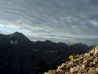
The view from the summit was intermittent, due to rolling fog which overtook the summit several times in my short stay. The developing clouds worried me also, while across the valley, Snowmass and Capitol remained hidden by a thick cloud of fog all day. Meanwhile, the views of North Maroon and Pyramid in the rolling fog were awesome.
I had arrived at the summit at 8:30, and I stayed twenty minutes. Besides my weather worries, the steady wind was keeping me chilled. I wanted to get past the crux of the traverse as quickly as possible.
South to North Traverse
Several
surprising drop-offs forced me to take my time getting to the saddle between Maroon Peak and North Maroon. The most difficult and nerve-wracking part for me was the abundant pebble-scree that coated the otherwise flat, sloping and sometimes wet rock. This was slippery and required my full attention, though the moves themselves were not bad at all.
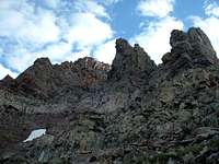
I got a good preview of
the first crux tower as I made my way to the saddle. Looking back now on other people’s photographs, I believe I may have taken a more difficult line than necessary. Instead of keeping with the west side of the tower, I traversed to the right (east) and climbed a vertical chimney with several small overhangs. To me it felt like low 5th class, though I do not have enough technical climbing experience to say for sure. About two-thirds of the way up the tower, I nearly pulled a suitcase-sized boulder down on me as I negotiated one of the tougher overhangs. I did not have to look down to know a fall here would be my last, so I stopped and performed a delicate balancing act to get around the loose rock without touching it again. Other than that one scary experience, the rock of the tower was solid.
![]()
Sleeping Sexton and North Maroon
I will admit, this climb was basically a
copy-cat endeavor of Kevin’s, which had taken place five days earlier. I had climbed Capitol Peak with him a couple weeks before, and found him to be a good, safe decision maker when it comes to climbing. Also more experienced than me, he had opted out of climbing the second and hardest crux tower of the traverse. Most other sources I’ve read claim there is no way around it, but his report succinctly described a longer path below the traverse ridge along the southwest face of North Maroon.
I might have tried the tower if I had someone along with me, but I was not going to push my limits while alone. I had passed three people in the dark along the approach trail, but I would see no one on the actual mountains all day.
Anyway, the traverse ledge was surprisingly well-cairned and easy to follow. It lost a good bit of elevation before finally exploiting the one weakness in the otherwise vertical-to-overhanging cliffs of North Maroon’s southwest face. This weakness was a steep and narrow gully leading back up to the ridge. There was some quality class 4 scrambling in this gully. I am not sure if I started at the optimal place, but to gain the gully I found myself climbing a
vertical slot chimney with very solid holds. A few more scrambles above this were also a lot of fun, including the final scramble
out of the gully to regain the ridge. However, there was plenty of loose stuff to deal with as well.
Now much closer to the summit of North Maroon Peak, I made quick progress the rest of the way
along the ridge to the final face below the summit. I enjoyed the scramble up the face. It was a lot like other Elk Range climbs such as Pyramid, Capitol and South Maroon, in that I could choose my own line and level of difficulty, scrambling and climbing all the way to the summit.
I arrived at North Maroon’s summit at 10:30, completing the traverse in 1 hr. 40 min. The weather had cleared while I did the traverse, and I had pretty much forgotten about it. However, as I enjoyed the view from North Maroon, I saw thunderheads already building to the west. I spent half an hour on the summit, making sure I was well-equipped for what promised to be a grueling descent, then I was on my way down the northeast ridge of North Maroon.
Stormy Descent of North Maroon
My best description for this descent? Tedious and never-ending. As I have read elsewhere, one truly does gain a respect for how massive these mountains really are during the knee-pulping descent.
There were a couple short down-climbs along the ridge, but they were no more difficult than what I had already done along the traverse. In actuality there was
nothing overly difficult about the descent; it was just
long, steep and tedious. What made things much worse was the weather. At around 13,000 feet, some light hail and rain began to fall. It was not coming down hard, but it was steady enough to soak everything. As I approached timberline around 12:30, thunder began. Unfortunately, when I finally made it to the clump of trees at the bottom of the gully, I realized the trail continued into a wide open rock glacier and traversed some rolling hills
before finally entering the actual forest.
The nice thing was that the trail flattened out for a bit to cross the rock glacier, so I was able to make decent time. Meanwhile, the rain began coming down harder, and lightning was crashing around me, a bit too close for comfort. The wet talus was also tedious, but much preferable to the mud slopes I was about to take on.
By the time I made it to the forest, the storm was in a lull, but the trail became more difficult. It was steep, muddy and slippery, and more than once I lost my footing on the way through the woods. After some soaking wet willow bashing, switchbacks down another talus field, and some more willow bashing, I emerged at a creek crossing. Already soaked, I tromped across the creek and followed the trail to the top of the next slope.
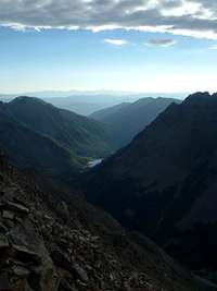
Finally I arrived at the Buckskin Pass Trail, which I followed back down to the Crater Lake Trail. The views of Pyramid Peak and the Bells were fantastic, and by the time I made it back to the main trail, the sun was shining and the storms were nowhere to be seen.
Conclusion
Several other hikers were plopped down on some rocks at the trail junction when I arrived. Relieved that the weather had cleared and happy for some social interaction, I joined them in their break.
While I thought I had just had a rough day, I listened in awe as they told me of their four day trip, starting on Monday with seventeen hours of nearly constant rain. They had driven from Kansas, then completed the four-pass backpack, crossing West Maroon Pass, Frigid Air Pass, Trail Rider Pass, and finally Buckskin Pass. The trip had to have been fantastic, taking in arguably some of the best scenery in the Lower 48 states.
As we sat there, a large muley doe wandered up to us and moseyed around along the trail. Seems she did not want to miss the party.
The rest was nice, but I was looking forward to getting back to my jeep and changing into something dry. One of the other hikers in the group walked along with me, as the others rested a little longer and caught up later. Mel was his name, and we talked the final sunny mile and a half back to the trailhead, making it go much faster.
I will agree with the oft-heard sentiment that I am glad to have the rotten, steep and dangerous Maroon Bells behind me, but it is a bittersweet thought, knowing that I will be leaving this beautiful state so soon. I hope to climb another mountain or two before leaving, but even if I don’t... at least I got to view the world from the lofty summit perches of the Bells while I was here!


Comments
Post a Comment