Introduction
The summer of weddings and 14ers continued with what we felt was our most challenging weekend yet. We had started the spring with a couple of fun snow-climbs and class 2 endurance builders, gradually venturing out to sharpen our scrambling ability on the more challenging class 3 climbs. After enjoying successful trips up the southwest ridge of Mount Sneffels and El Diente Peak last weekend, we were ready to take it up a notch and head to the Elk Mountains for Pyramid and Maroon Peaks. Pyramid would be our first class 4 climb and even though Maroon was still class 3 we knew it would also be one of our most challenging hikes so far.
Kevin Baker offered to climb Pyramid Peak with us and show us how it’s done, so we rendezvoused in Colorado Springs on Friday afternoon for the 4 hour drive to Aspen. Pyramid was first on the docket for Saturday and we decided to car camp in a small parking lot on the way up to Maroon Lake. We set our alarms for 3:30am and turned in for the night, anticipating the exhilarating climb ahead.
Climbing the Pyramid
Saturday, August 18, 2007
Pyramid Peak (14,015’) – CO Rank 47
Route: Northeast Ridge (Class 4)
Total Distance: ~8 miles
Elevation Gain: 4500 ft
All Pyramid Pictures
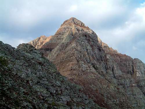
I was pleased to see stars in the sky when the alarm went off Saturday morning and we quickly packed up the car for a short drive up to the Maroon Lake trailhead, hiking by 4:02am. Karen set a quick pace for us on the short hike up to Crater Lake and we reached the turn-off to Pyramid just below the lake in 36 minutes. The next segment of the hike took us along a trail that we read had been improved by the Colorado Fourteener Initiative (CFI). We had to agree that they had done a nice job as the trail made long switchbacks up the hillside and was relatively easy to follow by headlamp. After gaining around 1000-ft of elevation, we came to the moraine that marks the entrance to the amphitheater. The trail was a little tricky to follow up the moraine in the dark so we did our best to find the path of least resistance. By the time we reached the center of the amphitheater the sun was putting out enough light for us to see the steep slopes we would climb to reach the northwest ridge, as well as an awesome first look at Pyramid’s steep north face. The first couple hundred feet of the steep slope up to the ridge was the loosest but we were moving along strong. The further we went the more stable ground we found and the slope seemed to taper off a bit, and we gained the saddle at 13,000-ft a little after 7:00am. The view of the remaining route to the summit from here was daunting but we were glad to be there with someone who had done it before and would be there to encourage us along the way.
![Pyramid Peak]() Pyramid's northeast ridge
Pyramid's northeast ridge
We primed ourselves to take it steady and deliberate, one step at a time. After the short snack and motivational break, we set off along the ridge around the right side of a large pinnacle.
![Pyramid Peak]() Not enough air below to take your hands out of your pockets yet Kevin?
Not enough air below to take your hands out of your pockets yet Kevin?
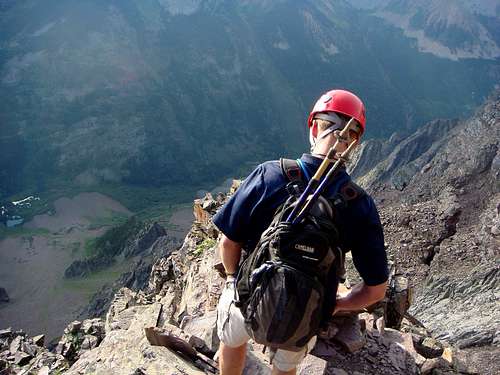
After a relatively short segment around a couple of rock ribs and a short leap across a 3-ft gap we came upon the infamous cliff traverse. I remember the first time I saw pictures of this traverse from Kevin’s trip report last year and it made my palms sweat just looking at it.
![Pyramid Peak]() Kevin on the infamous cliff traverse
Kevin on the infamous cliff traverse
Maybe it’s a few more 14ers under my belt talking, but I was a little surprised at my first look at this traverse in real life. It wasn’t that bad at all – in fact I’d even say it is one of the more over-hyped features of a 14er hike that I’ve been on. We did our best to create some scary looking pictures as well, but I found there to be plenty of room for my feet to stay firmly planted on the ledge and the drop-off was only about 30-40 feet. Crossing the ledge with ease gave me a big boost of confidence for the rest of the ascent and we quickly made our way over to the start of the Green Gully. The gully is rated as class 4 scrambling, and this would be Karen and my first attempt on rock this steep, so of course we were a little anxious about this moment. The good news is that we found this segment of the climb to be easier than expected as well as the class 4 climbing wasn’t really sustained and the rock was surprisingly solid. We continued up the gully, climbed a fun dihedral, and then exited left after a few hundred feet.
![Pyramid Peak]() Jim exiting the Green Gully
Jim exiting the Green Gully
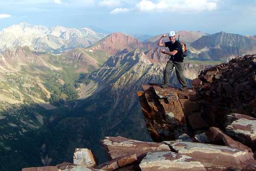
The rest of the route to the summit was a fun maze of route finding as we traversed a few moderately exposed ledges intermixed with short 5 to 15-ft scrambles up steep rock. Kevin had told us that the rock on Pyramid was more stable than some of the typical mountains in the Elks and he was right. Of course we continued on deliberately, checking each on of our hand and foot holds, but in general found the rock to provide for a lot of fun scrambling. We ventured a bit further left of the cairned route a few hundred feet below the summit and climbed up what turned out to be a couple of more steep sections than we had to, but it was good practice for us. Soon enough the summit was in sight and we were thrilled to reach the summit at 9:30am!
![Pyramid Peak]() The Maroon Bells
The Maroon Bells
It happened to be fairly cloudy already that day so the lighting was poor for pictures but we enjoyed the views of the surrounding 14ers. Another group of 3 summitted shortly after us, so we traded cameras for group photos and then grabbed a quick snack before heading down.
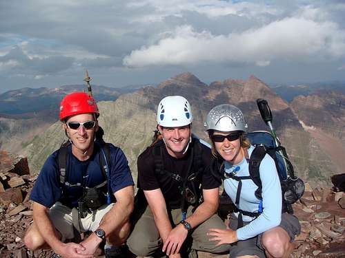
![Pyramid Peak]() Our summit photo
Our summit photo![Pyramid Peak]() Hi mom!
Hi mom!
The clouds hanging over the Maroon Bells to our west were looking iffy so we decided we’d better make steady progress back down to treeline. On our way down just below the summit we ran into Kurt, who we had met a month back at Kit Carson and was climbing with his friend Darryl on what was Darryl’s final 14er – congrats Darryl and Kurt! The route was a bit easier to follow on the way down as the cairns were more visible from above as were the trains of other hikers still coming up. We had to have passed 20 more climbers on the descent back to the saddle – glad we made it up early!
![Pyramid Peak]() Can you spot the climbers?
Can you spot the climbers?
Back across the cliff traverse, across to the saddle and down to the amphitheater we went, still charged that we had managed our first class 4 summit.
![Pyramid Peak]() Karen on the cliff traverse
Karen on the cliff traverse
The remainder of the hike back down to the trailhead was uneventful except for some great views of the Maroon Bells and speed hiking down from Crater Lake to finish off the hike at 1:02pm.
Denied by Maroon Peak
Sunday, August 19, 2007
Maroon Peak (14,156’) – CO Rank 27
Route: South Ridge (Class 3)
Total Distance: ~10 miles
Elevation Gain: 4500 ft
All Maroon Pictures
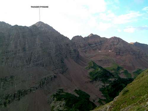
Even after a successful climb of Pyramid Peak on Saturday, we were somewhat skeptical of our chances to summit Maroon Peak on Sunday. We knew that we were facing a mountain that was still class 3, but known to be more challenging that Pyramid in terms of the route-finding involved and the general looseness of the terrain. Kevin was aiming for Thunder Pyramid and Lightning Pyramid with Darin and Sam today, so Karen and I were on our own for this one.
![Thunder Pyramid]() Thunder Pyramid
Thunder Pyramid
We had done our research of the route and started out with the same game plan as the day before – deliberate and steady, one step at a time. We left the Maroon trailhead at 4:00am again and made quick progress up to Crater Lake and then up the West Maroon Creek valley, reaching the turn-off to the south ridge right around sunrise. The next mile or so up to gain the south ridge was wicked steep, as we gained 2800’ vertical over that stretch, wandering off route a couple of times along the way. This segment of the route could definitely use some TLC from the CFI.
![Maroon Peak]() Pyramid Peak, seen from the trail up to the south ridge of Maroon
Pyramid Peak, seen from the trail up to the south ridge of Maroon
The view of the remaining traverse to the summit from the saddle of the south ridge was just as daunting as the view from Pyramid. Karen was pretty unnerved while we refueled on the saddle and we considered turning back as we knew this was likely going to be the most challenging ¾ mile we undertaken on a 14er.
![Maroon Peak]() Yes, that's where we're going
Yes, that's where we're going
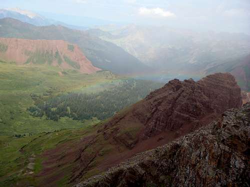
After some coaxing I convinced her to continue on with the game plan and take things one step at a time, and we set off along the traverse. We quickly came to a short chimney followed by a brief scramble up through a notch, making it through both without incident. I was feeling more encouraged at this point as I had read that these two features presented some of the most difficult climbing of the remaining route. After another short traverse we were faced with what would be the crux of the route for us – the twin gullies. We had read about an alternative route that splits off before the twin gullies and heads up and along the ridge –supposedly a route that follows more stable rock. However, not having a route description for that alternative, we decided to stick to the standard route. Initially, we aimed to ascend the first gully, but after reaching the entrance I decided we’d better have a look at the second gully instead. I still think the second gully was a better choice even though it was full of loose rubble and rocks the size of small appliances packed loosely together. We were definitely on alert ascending this gully as many rocks that we stepped on were just poised to tumble down and off the cliffs below us. Fortunately, we found more solid rock to cling to along the left side of the gully and climbed our way up to the next cairn – I was already not looking forward to the descent. We made another short ledge traverse around a rib into a second gully that was more seemingly more stable and not quite as steep as the last and quickly ascended. Yet another traverse over a couple of ribs and we came to a wide dirt-filled gully that lead up to a notch in the ridge. Karen ascended up some of the larger rocks in the middle of the gully and I stuck to the calf-burning dirt in the middle. Once reaching the notch we found the next cairn and also noticed the skies to our west. As we started to zig-zag our way up the ledges toward the summit it was apparent that there was a long line of clouds to our west that were already producing rain. 10:20am…..darnit! At that point we were about 300’ vertical from the summit but we had been traversing the south ridge now for about 2 hours. Dreading a descent on wet rock that was already extremely loose, we decided that prudence was better than valor today and turned back, quickly descending the zig-zags. About halfway down the wide gully, the skies opened up and it started to rain and I was starting to get really worried about what was still ahead of us. We put on our rain gear and continued around a couple of ribs back to the shallower gully. Shortly thereafter, the rain quit, the sun started to come out again, and we saw a rainbow appear down in the Fravert basin.
![Maroon Peak]() A rainbow appearing in Fravert Basin
A rainbow appearing in Fravert Basin
Somehow I can’t help but feel that was someone saying to me “I told you to turn around a while ago back at the saddle, thank you for listening to me this time.” Amazingly, the water that had started to accumulate on the rocks was drying up right in front of our eyes as the sun was breaking out of the clouds, and we started to contemplate heading back up toward the summit again, still only 600’ vertical away. No sooner did we utter those words, then we heard a rumble of thunder – “Perhaps I wasn’t clear.” Point taken, we’re headed down. We carefully made our way down the second of the twin gullies making sure that each other was clear of potential rock fall below us before moving, and traversed back over to the saddle. A group of other climbers who had traversed over from North Maroon Peak traversed above us the whole way apparently following the more stable ridge route. After talking to them, if I go back to Maroon Peak again, I’m going to find my way to and along that route and avoid the nasty gullies along the standard route. The descent from the saddle wasn’t as bad as I expected it to be as we were able to follow somewhat of a trail the entire way, but of course my knees were happy to reach the intersection with the creek again. We hiked back down to Maroon Lake, stopping for a short rest at Crater Lake, thankful to have made it as far as we did and be back down safely.
![Maroon Peak]() The Maroon Bells, from Crater Lake
The Maroon Bells, from Crater Lake
In hindsight, we didn’t hear any more thunder the rest of the day and we probably could have made it back to the summit and down again. But with the situation we were in at the time, we made the right decision.
Comments
No comments posted yet.