Thoughts on Orizaba
Pico de Orizaba is the third highest peak in North America at approximately 18,500 feet. Locals clued us into the main reason the summit elevation is not set in stone. Apparently high winds battering the soft volcanic crater rim make for a dynamic landscape. Ohhh, that makes sense.
This mountain was our first "high altitude" experience. We chose it for several reasons:
(1) Orizaba is low in technical difficulty
(2) Its close to our home of Boulder, Colorado
(3) Its glacier is disappearing and we wanted to see it outside of some picture on the internet.
A description of all the busing and what not needed to get to the mountain is not really important or worth noting in my opinion. We didn't feel the need to make any sort of itinerary or plan anything outside of, hmmm, buy a plane ticket, do Orizaba first, then Izta and try to fit in some cultural education. If you have done any backpacking outside the western world, getting around should be really easy for you, just figure it out when you get there. Spanish helps, a lot. If you don’t know Spanish, one of the other romance languages will go a long way.
Our acclimatization scheme worked extremely well for us. I made a dozen or so winter trips with heavy gear loads to 13,800’+ in Colorado over the course of the winter but Debbie had far less opportunities. A week before we left, we hiked La Plata Peak ~14,300’, which was her only time in thin air for quite some time before the trip. I feel the most important aspect of our acclimatization was tons of water on the mountain. For Orizaba, over 48 hours together we drank nearly 30 liters of water.
We found the Piedra Grande hut to be in excellent condition despite reading reports to the contrary on the internet. The other hut, a smaller sheet metal structure, seemed quite worth of a good night sleep as well, although with high wind it would be noisy.
During this time of the year, water is available during the afternoons at base camp from the glacial runoff. You should obviously filter it and boil it, as it is filled with heavy silt and the plenty of human waste is spread about. After midnight or so, the runoff stops due to freezing temps on the upper mountain.
Day 1
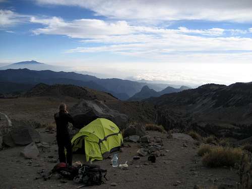
After rocking and rolling in the back of a work truck for a few hours we found ourselves unloading our gear at the Piedra Grande hut, base camp for the Jampa Glacier route. It was 2 pm on the 25th of March. Clouds billowed up the grassy volcanic slopes reaching all the way up to the summit. A stream of glacial runoff roared down the mountain 100 yards away. Our supplies included 30 liters of water, 6 days of freeze dried food, camping and hiking gear. We brought a 30m 8mm rope, 2 ice screws, an ice piton, slings and tricams in the case the labyrinth or glacier required pro. After setting up our tent in a modest rock wall shelter we ate lunch and relaxed. We definitely felt the 14,000’ elevation, as even a short walk resulted in tired legs and deep breathing. A short hike was in order to get the blood flowing, so we slowly, and I mean slowly, walked up the cement aqueduct above the camp to its first switchback. The mini acclimatization hike was all of a quarter mile and 200’ feet of vertical. Around 3 pm, loads of people started arriving at camp from their attempts on the summit that day. The first group that arrived was a few guys from California. They were thoroughly spent (nearly unconscious) but were happy to be the two successful climbers in the five person party. They spoke of difficulties through the labyrinth requiring them to set fixed line. A guide of another group told me later it was simple and the glacier was in easy climbing condition. Some card games, plenty of water and food and 11 hours of sleep later, day two began.
Day 2
We woke when we woke, which happened to be around 8 am, ate breakfast and geared up for an acclimatization hike. We planned on carrying our technical gear, a gallon of water and trail food to high camp (16,000’) and then returning to base camp. The initial section of the route follows climbers right of the main glacier runoff, ascending a loose 35 degree scree and boulder strewn slope.
Temperatures were in the 50s and the sky was blue. Smog from the massive metropolis of Mexico City and its sister cities covered the plains 10,000’ below. We had to fight our natural urge to hike fast, this wasn’t Colorado. Instead, we took very deliberate slow steps up the loose terrain and drank lots of water. The trail is quite easy to follow in daylight. There are two trails really, a somewhat solid ascent path and another scree skiing descent chute. It was a neat feeling to know that after ~14,400’ with every step we took we were setting our new high altitude marks.
![Lower section of Jampa Glacier Route]()
At the top of the loose slope, the route briefly follows solid rock ribs above cliffs before gaining gentler terrain. Two options present themselves at this point. You can either scramble up onto a rock rib running straight toward the upper mountain or stay in the glacier runoff drainage to the right of the rib. We chose the latter. At the end of the rib, we found high camp. We stashed our gear in a wind shelter and began to discuss our attack plan for the labyrinth, which stood in front of us.
![Jampa Glacier route from Mid Camp]()
![Labyrinth from High Camp]()
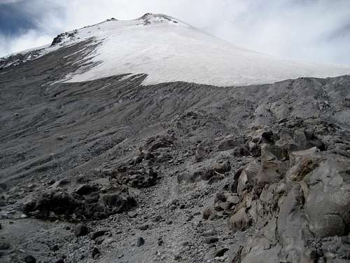
The labyrinth is a scar upon the ancient lava flows left by the receded glacier. It looks like a rolling jumble of gigantic elephant bodies, set in stone for the foreseeable future. Ice flows cascaded down significant sections of it and an occasional snow bank hid beneath shadowy out crops. It does look formidable from below. We had heard you can stay right of the whole mess and ascend steep scree slopes below the Sarcofigo all the way to the base of the glacier. This route was clear from high camp, but appeared to be quite a chore as the terminus of several rock glaciers would have to be navigated. I decided to see how the route finding was through the labyrinth proper and headed off into the unknown. A few boot prints and an occasional cairn later I found myself making good progress through the maze.
![Looking across the upper Labyrinth at the Sarcofaco]()
After 20 minutes, I was on top of the major difficulties waving down to Debbie 600’ below. I felt really good for being 2,400’ higher than ever before. I could see the glacier in its entirety above us. It looked small and was a sad site. Instead of the ice flows of a decade ago, vast areas of dark ash fields are exposed. Global warming is on the march.
On the way back down to high camp I cairned the route through the labyrinth very well so we could find it easily the next morning during our summit bid. After arriving back at base camp, we took it really easy consuming lots of water and plenty of food. The daily flow of dense face wetting clouds arrived around 1 pm, making for entertaining vistas of the valleys below and above. Sleep ensued around 7pm with nightfall. The alarm was set for midnight.
Summit Day 3
The alarm came swiftly. After hot breakfast and some prep work, we hit the trail at 1:15 am. A lost bag of gear on the flight into Mexico City from Phoenix had us using old borrowed headlamps. Unfortunately, one of them burned batteries like a college student drinking Keystone Light; it was out in 30 minutes. With one lamp, our progressed slowed a bit but high camp still came quickly in an hour and forty minutes. We picked up the gear stash and headed into the labyrinth. Here the single headlamp became more of an issue as the terrain involved a good deal of class 2+ and a bit of class 3. I would ascend a short section, and then guide Debbie through it with the lamp. Finding the route was easy after seeing and marking it the day before, but it still took us 1.5 hours.
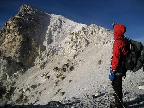
The most memorable part of the trip was rapidly approaching. After making it to the point I stopped 13 hours earlier, we once again headed into unknown territory with an ascent of loose slopes of old ash and rubble. In 15 minutes we spotted snow and ice. If you haven’t heard the sound of a glacier refreezing from a warm day, it’s very a unique sound. We began gearing up and out of the darkness came a loud crack and then the sound of breaking glass. Over and over this repeated. At first, it was quite eerie for Debbie and I, as where we come from the snow is mute. We later realized it was the ice cracking violently due to the expanding mass of refreezing water. With each crack, the penetites above the fracture would spray up into the air crashing down like a shattered window. Cool stuff.
Since we had some beta that the upper, steepest section of the glacier was water ice, we roped up. The climbing was easy over serrated snow and brief sections of water ice. The lower 500 feet of the glacier was gentle, not exceeding 25 or 30 degrees.
![Jampa Glacial Conditions, March 2007]() Glacier Conditions, March 2007
Glacier Conditions, March 2007![Jampa Glacier Crevasse]() Crevasse, March 2007
Crevasse, March 2007We spotted a few small crevasses through here, but nothing worth worrying about. As the glacier steepened, the sun began to light the eastern sky. The views illuminated below us and the colors sweeping across the sky made for one of the best sunrises I have ever witnessed. Of course, we spotted the huge pyramidal shadow of the peak stretching many miles to the west.
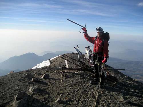
A maximum angle of 48 degrees was measured through the upper 200 feet of the glacier below the crater rim. The old route use to swing east before reaching the crater rim, but now the best route ascends directly up the slope. As you top out on the crater, a vast change of scenery meets you with a faint smell of sulfur and 360 degrees of rugged vertical cliffs.
After a brief break, we finished the last 100 feet to the top of Mexico.
We didn’t really feel adverse effects from the altitude until 17,500, where Debbie slowed. I felt a serious lack of oxygen take over at 18,000’. From there to the summit, it was 10 steps and then rest for 20 seconds. We decided to climb to a mountain over 19,000’, a higher camp would be required. The views on this mountain are well worth the climb. We could see Popo, Izta and La Malinche as well as many small villages at the base of the massive 10,000 feet of vertical relief. We had the mountain completely to ourselves this day.
We didn’t stay on the summit long, as Debbie didn’t feel great. The descent of the glacier was straightforward although somewhat taxing due the heavily serrated snow. We used hiking poles, not axes, with crampons as there was little to no fall danger. Back to camp with a round trip of 9 hours. 6 hours up from Piedra Grande, 3 hours down. We had plenty of time before our ride arrived to reflect on our climb, relax and pack up. Success! This 9 day trip concluded with a visit to the third largest pyramid in the world at Teotihuacan, a summit of Iztaccihuatl (17,200’) and then tours of Mexico City’s urban and historic districts.


Comments
Post a Comment