Twin Couloirs

Page Type Page Type: Route
Location Lat/Lon: 40.4595°S / 112.62550°E
Additional Information Route Type: Hiking, Mountaineering, Skiing
Seasons Season: Spring, Summer, Winter
Additional Information Time Required: Half a day
Additional Information Rock Difficulty: Class 3
Additional Information Grade: II
Sign the Climber's Log

Overview

Western Twin CouloirWestern Twin
The Twin Couloirs are two north-facing couloirs approximately 0.3 mile to the southeast of the summit of Deseret Peak. Because they face north, they hold snow well into the late spring and early summer months, suitable for snow-climbing and spring skiing. These twin couloirs are very aesthetic, with high quartzite walls on both sides. They provide a 1300 foot climb and descent.

Getting There

From Exit 99 on Interstate 80 (Tooele, Stansbury):
- exit and head south on Highway 36 for about 4 miles
- turn onto Highway 138 to Grantsville
- Once in Grantsville, drive to the west side of town and turn south on 400W
- Follow signs for the Deseret Peak Wilderness
- Park at the "Loop Campground" parking (at the end of the road)

This road turns to dirt nearer to the Loop Campground, but should be suitable for all cars.

Route Description

Skiing the Twin CouloirsSkiing the Twin Couloirs
From the Loop Campground Trailhead, follow the trail south and shortly enter the Deseret Peak Wilderness Area. After 0.7 mile, cross a creek and find the trail intersection for the Mill Fork trail and the Dry Fork / Pockets Fork trail (also goes to South Willow Lake). Take the right fork in the trail that heads toward South Willow Lake. After 0.5 miles, you'll be at the point where the trail turns sharply to the north. If you're snow climbing, you'll likely already be on snow. Leave the trail and climb into Dry Lake Fork. Travel south on snow toward the large cirque created by Deseret Peak. The Twin Couloirs are southeast of the summit, so once you identify them, just head toward the apron below the couloirs.

From here, climb 1300 vertical feet to the top of the couloirs. The western couloir is slightly less steep and wider than the eastern couloir. The western coulior is 36 degrees, the eastern couloir is 38 degrees. I was able to skin (with some difficulty) the entire western coulior in June. Either couloir would be a really straightforward snow climb.

Route (to the top of the Twin Couloirs):
4.8 miles round trip
3239 feet elevation gain

To the summit:
5.4 miles round trip
3643 feet elevation gain

Skiing "D" Rating:
II D6 R2

Essential Gear

Snow climbing gear and / or skis.

The high walls of these couliors drop a considerable amount of rocks on you as you climb, so a rock helmet might not be a bad idea.
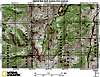
Topo Map

Topo
Eastern Twin CouloirDoes this look like fun to you?


Parents 

Parents

Parents refers to a larger category under which an object falls. For example, theAconcagua mountain page has the 'Aconcagua Group' and the 'Seven Summits' asparents and is a parent itself to many routes, photos, and Trip Reports.