
-
 5373 Hits
-
 84.82% Score
-
 19 Votes
|
|
Mountain/Rock |
|---|---|
|
|
38.61710°N / 106.3669°W |
|
|
Chaffee & Gunnison |
|
|
Hiking |
|
|
Spring, Summer, Fall, Winter |
|
|
13111 ft / 3996 m |
|
|
Overview
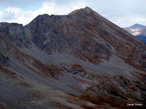 "Hancock Peak" from Chalk Creek Pass
Rising high and proud above Hancock Pass along the Continental Divide is UN 13111, aptly nicknamed “Hancock Peak.” Everything in this area seems to be named Hancock, from the town site to the pass to the lakes and the jeep road running to them, yet UN 13111 remains officially nameless. From Hancock Lake, the peak is a powerful presence, with steep northeastern slopes capped by a knobby point. When viewed from the south atop Pt. 13254, “Hancock Peak” takes its place along a snaking, sinuous ridge that makes up the Continental Divide.
The peak resides on the western edge of the Sawatch Range in the San Isabel National Forest. To the east, north and south from the summit, one sees an impressive ocean of fellow Sawatch peaks. To the west across a vast valley, the San Juans rise in the distance. To sit on the summit of “Hancock Peak” enjoying the views is to ponder: So many mountains, so little time!
Colorado Rank: 560th highest peak in Colorado
Prominence: 491 feet
USGS Quad: Garfield
Planning Map: Trails Illustrated #130 Salida, St. Elmo | Mount Shavano
Rank & Prominence Source: Lists of John
Getting There
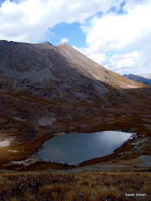 "Hancock Peak" above Upper Hancock Lake
Bordered by US 285 to the east and US 50 to the south, and served by numerous Jeep roads and foot/pack trails, UN 13111 is an extraordinarily accessible peak. Though the approach options numerous, the below table summarizes primary approach points and variations.
| Access Point | Origination | General Driving Directions |
|---|---|---|
| Hancock | US 285 near Nathrop | From Hwy 285 near Nathrop, head west on Rt 162. Follow Rt 162 west for 15 miles to Hancock Road (FS 295). Suitable for passenger cars to Hancock Townsite. Route gets increasingly rough to Hancock Pass. |
| South Access from US 50 | Several variations | From Salida, follow US 50 westbound. Depending on your preferences, follow Middle Fork Road (FS 230, 4x4) northwest out of Garfield, follow Boss Lake Road (FS 235, 4x4), ascend via Waterdog Lake Trail (#1417) or catch the Continental Divide Trail from near Monarch Ski Area. |
| Western Access | Several variations | Follow Alpine Tunnel Road (FS 839) or Tomichi Pass Road (FS 888, 4x4) toward Hancock Pass |
Red Tape
 "Hancock Peak" from the north "Hancock Peak" from the north | Very little red tape governs use of this area. There are no fees or permits required to access “Hancock Peak.” Minus a private inholding here and there, the peak is surrounded by the San Isabel National Forest where there are few limitations on recreational usage by the public. |  "Hancock Peak" at left "Hancock Peak" at left |
 "Hancock Peak" from Chalk Creek Pass area "Hancock Peak" from Chalk Creek Pass area | 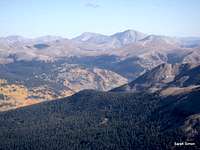 "Hancock Peak" from Chalk Creek Pass area "Hancock Peak" from Chalk Creek Pass area | 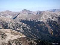 "Hancock Peak" from Chalk Creek Pass area "Hancock Peak" from Chalk Creek Pass area |
Camping
 "Hancock Peak" shadow
• Rustic, undeveloped camping abounds in all directions surrounding “Hancock Peak.” Both 4x4 camping as well as back-packing camping are available on a un-permitted, first-come, first-served bases off of the Forest Service roads and trails throughout the San Isabel Nation Forest.
• The nearest established USFS campground to “Hancock Peak” is the Middle Quarts campground on the west side of the peak, reached via Middle Quartz Creek Road (FS 767).
 Van Wirt Mountain and "Hancock Peak" Van Wirt Mountain and "Hancock Peak" |  Southwest from "Hancock Peak" Southwest from "Hancock Peak" |
Weather & Seasons
 Mountain Goat on the summit Mountain Goat on the summit |  Ascending west slope talus Ascending west slope talus |  Goats en route to the summit Goats en route to the summit |
 | As with most mountains in Colorado, UN 13111 can enjoyably be climbed year-round with caveats, properly-set expectations, and seasonally-appropriate preparation and skill. As with most any high peak on the Continental Divide, expect to contend with strong winds almost any day of the year, regardless of season. Summer: Crowds, many radiating from the nearby town of Buena Vista, descend on the lovely Sawatch Mountains in the summer months. These peaks are popular with residents of Colorado and vacationers alike and used for hiking, climbing, horseback riding, 4-wheeling, fishing…pretty much everything. Summer is also prime season for afternoon convection thunderstorms. Fall: Fall is a simply amazing time to visit this area as the golden aspen are plentiful and the worst of the crowds are mostly dispersed. The days are shorter, but the temperatures cool and crisp and the risk of afternoon thunderstorms decreased. Winter: Winter is beautiful in the Sawatch, but avalanche risk on steep Sawatch slopes combined with finicky Colorado snow pack definitely ups the ante. Additionally, heavy snows will render approach roads impassable, even if only temporarily, making for greater mileage and elevation gain and demanding a lot of output for a day trip or willingness to cold-weather backpack. Spring: The days at last become longer and the temperatures increase, yet Spring can mean deep, soggy snow pack and wet slides while road access can still be an issue. |  |
 "Hancock Peak" and Van Wirt Mountain "Hancock Peak" and Van Wirt Mountain |  Southwestern slopes of "Hancock Peak" Southwestern slopes of "Hancock Peak" |  Chalk Creek Basin Chalk Creek Basin |