
-
 4080 Hits
-
 79.04% Score
-
 10 Votes
|
|
Route |
|---|---|
|
|
38.62080°N / 106.3741°W |
|
|
Hiking |
|
|
Summer, Fall |
|
|
Most of a day |
|
|
Overview
 Remainder of Route from southern slopes of "Hancock Peak"
This route provides for a great day’s adventure, combing an easy Jeep trip with a slog up and down talus to visit the summits of three Sawatch Thirteeners. The scenery in every direction is non-stop and jaw-dropping. The talus can be cumbersome at times, but with careful route-finding solid footing can most always be found.
This route is high, largely trackless and delightfully wild. It would, however, be a bad place to get stuck in bad weather as there are few bailout options. A clear day with a solid high-pressures system would be ideal for this outing.
This route follows both the Continental Divide as well as the Chaffee County / Gunnison County line.
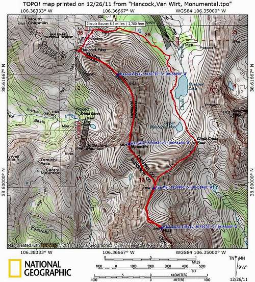
Roundtrip Distance: 6.5 miles
NET Elevation Gain: 2,700 feet (cumulative much higher)
YDS Class: 2+
 Route Elevation Profile
Getting There
 |  |  |

To reach Hancock Pass from the east
From Hwy 285 near Nathrop, head west on Rt 162. Follow Rt 162 west for 15 miles to Hancock Road (FS 295). This road is suitable for passenger cars to the Hancock Townsite, but the route gets increasingly rough toward Hancock Pass. Those with low-slung 4x4s may wish to park at the turn-off for Hancock Lakes. Otherwise, continue on increasingly rocky terrain to park at Hancock Pass, elevation 12,140 feet. A few boulders, hairpin turns and rock ledges make this route fun for reasonably experienced drivers with a beefy stock 4x4, but it might be a bit much for inexperienced off-road drivers or those pushing their vehicles to their limits.
This driving route is not only incredibly scenic but chock-full of mining history, so I recommend allowing time on your descent to explore the area. The drive will take you past or near the townsites of St.Elmo, Iron City, Romley and Hancock.
 Easy section of dirt road Easy section of dirt road |  Hancock Pass parking Hancock Pass parking Hancock Pass 12,240 ft. Hancock Pass 12,240 ft. |
Route Map
 Mount Aetna and Middle Fork Mount Aetna and Middle Fork | 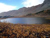 Pomeroy Mountain from Hancock Lakes Pomeroy Mountain from Hancock Lakes |
Key Waypoints
| Feature | Latutude | Longitude |
|---|---|---|
| Hancock Pass | 38.6208 | -106.3741 |
| "Hancock Peak" | 38.6171 | -106.3669 |
| Van Wirt | 38.6061 | -106.3646 |
| "Van Wit" | 38.5990 | -106.3596 |
| Monumental Peak | 38.5927 | -106.3580 |
| Chalk Creek Pass | 38.6063 | -106.3505 |
| Hancock Lakes | 38.6151 | -106.3538 |
Route Description
From the rustic parking area at Hancock Pass, ascend the talus on the northern ridge of “Hancock Peak.” After just a bit more than ½ mile of travel and few minor false summits, you will reach the top. Glorious talus slog out of Hancock Pass Glorious talus slog out of Hancock Pass | 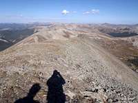 Looking back toward Hancock Pass from "Hancock Peak" Looking back toward Hancock Pass from "Hancock Peak" |  North toward "Hancock Peak" summit from southern slope North toward "Hancock Peak" summit from southern slope |
Descend “Hancock Peak” in a curving line trending mostly southward toward Van Wirt Mountain. Approximately 1 mile away from “Hancock Peak,” reach the summit of Van Wirt.
 Descending the southern slopes of "Hancock Peak" Descending the southern slopes of "Hancock Peak" |  North from Van Wirt North from Van Wirt |
 Ascending Van Wirt Mountain
 Descend steeply down steep talus of Van Wirt mountain to a saddle between Van Wirt and “Van Wit.” Begin climbing again to top out on the un-named, un-ranked “Van Wit.”
 Summit of "Van Wit" Summit of "Van Wit" |  Northeast from "Van Wit" Northeast from "Van Wit" |  North-northeast from "Van Wit" North-northeast from "Van Wit" |
From there, the summit of Monumental Peak is only ½ mile away as the raven flies, but it looms pretty menacingly ahead and above you.
 Across Hancock Pass from "Van Wit" Across Hancock Pass from "Van Wit" | 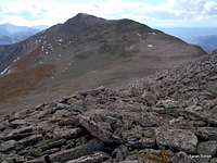 Monumental Peak Monumental Peak |  Across Chalk Creek Pass Across Chalk Creek Pass |
Strike out on a curving line following the ridge crest. The terrain is a mix if rocky talus and tundra all the way to the summit of Monumental Peak.
 Views east from Monumental Peak Views east from Monumental Peak |  Tomichi Creek drainage Tomichi Creek drainage |  Descending Monumental Peak Descending Monumental Peak |
After savoring the views from Monumental Peak, retrace your steps back to “Van Wit.”
 Looking back along the route from Monumental Peak
 From the top of “Van Wit,” descend northeast toward Chalk Creek Pass over large blocks. (This was my least-favorite part of the trip. Easy scrambling is required, but by this time I was ready to just let out my stride and stretch my legs on tundra or a trail.)
 Descending "Van Wit" Descending "Van Wit" |  Talus descent to Chalk Creek Pass Talus descent to Chalk Creek Pass |  UN 13147 and Mount Aetna UN 13147 and Mount Aetna |
Nearing Chalk Creek Pass, the footing turns thankfully to tundra. Hop on the pack trail and head north-northeast (left) down Chalk Cree Pass. Enjoy the smooth footing for a change and quickly descend into the willows to the Hancock Lakes.
 Dropping into Hancock Lakes
 Continue on the trail to the parking area for FS 295. Here, depart the trail and navigate through willows and mostly sparse timber for about ¾ mile to regain the road to Hancock Pass. Use an un-named little pond about mid-way between the two roads as a landmark.
Ascend the rocky dirt road trending southwest back to your 4x4!
Essential Gear
 Hancock Lakes
 Trails Illustrated #130 Salida, St. Elmo | Mount Shavano
Colorado Atlas and Gazatteer
Solid, supporting boots with good grip for all the talus slogging
Plenty of water for the dry ridge run
Outerwear appropriate to the season