
-
 13214 Hits
-
 81.84% Score
-
 14 Votes
|
|
Mountain/Rock |
|---|---|
|
|
38.91820°N / 105.0164°W |
|
|
El Paso |
|
|
Hiking |
|
|
Spring, Summer, Fall, Winter |
|
|
9540 ft / 2908 m |
|
|
Overview

Mount Esther from Mount Heizer24 Jan 2009
Five and one-half miles north-northeast of Pikes Peak sits a mellow, double-humped peak nicknamed “Mount Esther”. Plenty of Colorado Springs locals probably know of the Mount Esther Trail without knowing for certain that a mountain of that name sits “up there somewhere”. “Mount Esther” is close enough to town to make for a quick, pleasant getaway, but still provides big-sky, in-the-boonies views of Pikes Peak.
There exists some uncertainty as to which summit is the actual high point of Mount Esther. As a result, I will refrain at this point from proclaiming either the Northwest Summit or Southeast Summit to be the highpoint and simply approach this peak as one with a double-headed summit.
Colorado Rank: Unranked
Prominence: 280 feet
Mountain Range: Front Range
USGS Quad: Woodland Park
Trails Illustrated Map: #137 (Pikes Peak, Cañon City)
Rank and Prominence Reference: Lists of John
![Mount Esther Area Map]()
Click image to enlarge
Curfew: Generally speaking, the gates at the tollbooth close at 7:00 PM in the summer and 5:00 PM in the winter. Check the Pikes Peak Highway Website or call 719-385-Peak to check when the gates will be closed for the day you plan to visit.
Fees: As of this writing, the fee for the Toll Road is $10.00 per adult (16 and over $5.00 per child (6 - 15) or total $35.00 per car. Cash and credit cards (Visa and Master Card) are accepted. However, if you are not going to the top of the mountain, let the gate attendant know. A special rate of $4.00 per adult is available for visitors going only as far as Crow Gulch. Be honest and do not take advantage of this special program.
The area surrounding Mount Esther is built up to the extent that backcountry camping would not be a particularly appealing option. Neither of the primary trailheads (Crow Gulch and Mount Esther in Chipita Park) offer camping.
The nearest US Forest Service campsites would be in the Rampart Reservoir area. Be forewarned that the proximity of this area to the urban I-25 corridor means that crowding can be an issue, especially in the summer, and that unsavory characters are known to frequent this area. Be prepared for heavy ATV use, large crowds, drunkenness and casual firearms usage.
Meadow Ridge Campground:
Ghost tree on southeast summit / Golden field in Crow Gulch / Pikes Peak from SE Summit.
Click on images to enlarge.
HOTELS
The town of Chipita Park is about mid-way between Colorado Springs and Woodland Park on Hwy 24 (Ute Pass).
Woodland Park
A few simple hotels (many family-run) are available in Woodland Park (elevation 8,465 feet) along with several RV sites and cabins. For more information visit The Greater Woodland Park Chamber of Commerce Visitor Information page.
Manitou Springs
Manitou Springs lies at the foot of Ute Pass. This colorful, eclectic town offers a wide range of lodging options including old-style motor cottages and cabins, retro family-run motels, charming B&Bs and modern chain hotels. Shopping and dining are within walking distance of most Manitou lodging.
Colorado Springs
The hotel options in Colorado Springs are virtually limitless. If you are the 5-star luxury type, be sure to check out The Broadmoor.
Winter: Typically, this would be a very pleasant hike, free from crowds, in the winter. However, heavy winter snows would close the Pikes Peak Toll Road and make the route from Chipita Park cumbersome.
Summer: The crowds using the Pikes Peak Toll Road could be overbearing in the summer months.

Colorado Rank: Unranked
Prominence: 280 feet
Mountain Range: Front Range
USGS Quad: Woodland Park
Trails Illustrated Map: #137 (Pikes Peak, Cañon City)
Rank and Prominence Reference: Lists of John
Getting There
Mount Esther rises just north of the Ute Pass / Hwy 24 community of Chipita Park, a western exurb of Colorado Springs. The mountain sits in western El Paso County, not far from the border with Teller County.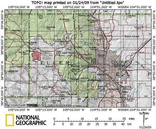
Click image to enlarge
Route Overview
| Route | Approximate Mileage | Approximate Elevation Gain | Special Note | Driving Directions |
|---|---|---|---|---|
| Mount Esther Trail | 5 miles roundtrip | 1,500 ft. | Steeper approach and better workout, but tougher to locate the trailhead. | Mt. Esther TH on Mountain Rd. in Chipita Park, just south of the intersection with Picabo Rd. |
| Crow Gulch Routet | 4.25 miles roundtrip | 900 ft. | Easy to locate trailhead with plenty of parking and mild elevation gain. | Take Highway 24 to Cascade, Colorado. Follow the signs to Pikes Peak Highway, heading west at the traffic light. |
Red Tape
If accessing Mount Esther from the Pikes Peak Tollway, usage fees and curfews apply.Curfew: Generally speaking, the gates at the tollbooth close at 7:00 PM in the summer and 5:00 PM in the winter. Check the Pikes Peak Highway Website or call 719-385-Peak to check when the gates will be closed for the day you plan to visit.
Fees: As of this writing, the fee for the Toll Road is $10.00 per adult (16 and over $5.00 per child (6 - 15) or total $35.00 per car. Cash and credit cards (Visa and Master Card) are accepted. However, if you are not going to the top of the mountain, let the gate attendant know. A special rate of $4.00 per adult is available for visitors going only as far as Crow Gulch. Be honest and do not take advantage of this special program.
Camping & Lodging
CAMPINGThe area surrounding Mount Esther is built up to the extent that backcountry camping would not be a particularly appealing option. Neither of the primary trailheads (Crow Gulch and Mount Esther in Chipita Park) offer camping.
The nearest US Forest Service campsites would be in the Rampart Reservoir area. Be forewarned that the proximity of this area to the urban I-25 corridor means that crowding can be an issue, especially in the summer, and that unsavory characters are known to frequent this area. Be prepared for heavy ATV use, large crowds, drunkenness and casual firearms usage.
Meadow Ridge Campground:
- 19 campsites
- 9,200 feet elevation
- Season: Generally early May through September
- $15 per night, per site
- Amenities include tables, fire grates, drinking water, latrines, and trash collection
- 21 campsites
- 9,200 feet elevation
- Season: Generally early May through September
- $15 per night, per site
- Amenities include tables, fire grates, drinking water, latrines, and trash collection
 |  |  |
Click on images to enlarge.
HOTELS
The town of Chipita Park is about mid-way between Colorado Springs and Woodland Park on Hwy 24 (Ute Pass).
Woodland Park
A few simple hotels (many family-run) are available in Woodland Park (elevation 8,465 feet) along with several RV sites and cabins. For more information visit The Greater Woodland Park Chamber of Commerce Visitor Information page.
Manitou Springs
Manitou Springs lies at the foot of Ute Pass. This colorful, eclectic town offers a wide range of lodging options including old-style motor cottages and cabins, retro family-run motels, charming B&Bs and modern chain hotels. Shopping and dining are within walking distance of most Manitou lodging.
Colorado Springs
The hotel options in Colorado Springs are virtually limitless. If you are the 5-star luxury type, be sure to check out The Broadmoor.
Weather & Seasons
Due to relatively low altitude, Mount Esther is a reasonable year-round summit objective.Winter: Typically, this would be a very pleasant hike, free from crowds, in the winter. However, heavy winter snows would close the Pikes Peak Toll Road and make the route from Chipita Park cumbersome.
Summer: The crowds using the Pikes Peak Toll Road could be overbearing in the summer months.