
-
 38899 Hits
-
 96.63% Score
-
 61 Votes
|
|
Canyon |
|---|---|
|
|
38.81800°N / 108.6012°W |
|
|
Hiking, Trad Climbing, Sport Climbing, Bouldering |
|
|
Spring, Summer, Fall |
|
|
Overview
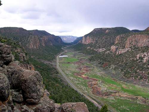 Unaweep Canyon North to South View
Unaweep canyon is a place of pristine beauty and one of the most spectacular but least known rock climbing areas in the Western United States. There is a potential for a lot of rock climbing development, but unfortunately many cliffs are located on private land and not accessible. Still, there are more than 1000 routes to climb! When one drives through the canyon, you can see rock routes all over...![Unaweep Canyon]() Unaweep CanyonUnaweep is a Ute Indian name that translates into "canyon with two mouth". Unaweep is truly unique as it is the only canyon in the world with a divide in the middle and streams running out of both ends. Unaweep Divide splits the canyon, with East Creek draining east to the Gunnison River and West Creek draining west to the Dolores River. Cattle ranching and farming continue to be the main livelihood in Unaweep Canyon. Almost the entire canyon bottom is privately owned by a combination of a few large ranching families and private residences on 10 to 40 acre parcels. Nine-Mile Hill: A legendary wagon route once used for hauling supplies into and radium ore out of Gateway during the radium boom of early 1900s. During this time, Nine-Mile Hills' grueling 18% grade often exhausted the stock teams pulling wagonloads up and down. This route, that is now Colorado Highway 141, was once known as Uranium Road. It served as the only access between the ore-rich mines in Gateway, Uravan, Naturita and Nucla and the processing mills in Grand Junction. Today, Nine-Mile Hill is only five miles long and less steep than before. You have to drive it before descending into the main canyon. Unaweep-Tabeguache Highway is a scenic highway going through Unaweep Canyon. The section of this highway played an integral role in World War II. The uranium used in the country's first atomic bombs was mined near Uravan.
Unaweep CanyonUnaweep is a Ute Indian name that translates into "canyon with two mouth". Unaweep is truly unique as it is the only canyon in the world with a divide in the middle and streams running out of both ends. Unaweep Divide splits the canyon, with East Creek draining east to the Gunnison River and West Creek draining west to the Dolores River. Cattle ranching and farming continue to be the main livelihood in Unaweep Canyon. Almost the entire canyon bottom is privately owned by a combination of a few large ranching families and private residences on 10 to 40 acre parcels. Nine-Mile Hill: A legendary wagon route once used for hauling supplies into and radium ore out of Gateway during the radium boom of early 1900s. During this time, Nine-Mile Hills' grueling 18% grade often exhausted the stock teams pulling wagonloads up and down. This route, that is now Colorado Highway 141, was once known as Uranium Road. It served as the only access between the ore-rich mines in Gateway, Uravan, Naturita and Nucla and the processing mills in Grand Junction. Today, Nine-Mile Hill is only five miles long and less steep than before. You have to drive it before descending into the main canyon. Unaweep-Tabeguache Highway is a scenic highway going through Unaweep Canyon. The section of this highway played an integral role in World War II. The uranium used in the country's first atomic bombs was mined near Uravan.
 Unaweep Canyon
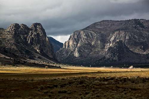
The canyon is a popular rock climbing destination. It is conveniently located near Grand Junction and once can dry through scenic Highway 141 and explore less known climbing areas of western Colorado. The highway 141 goes by a small community of Gateway, Sewemup Mesa (great sandstone climbing) and to the cliffs by Naturita. There is also ice climbing in Unaweep. See paragraph below for more information. Fall Colors in Unaweep
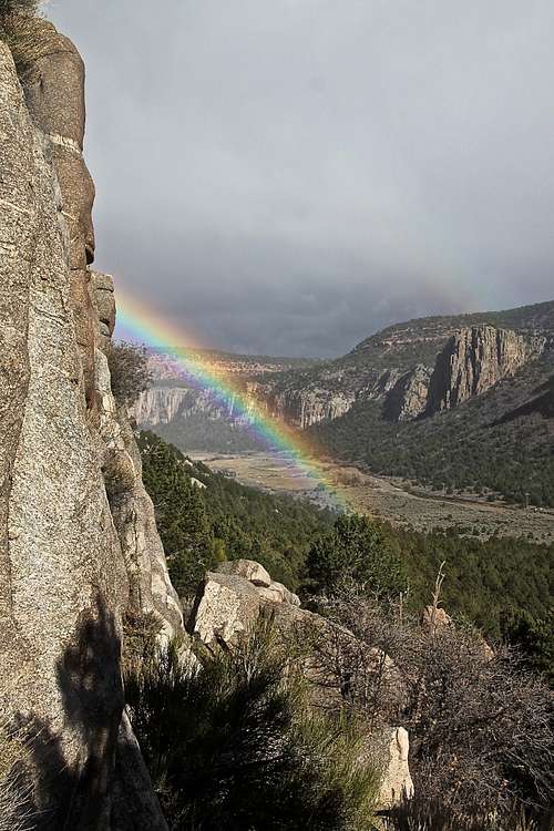
![Rainbow from Sunday Wall]() Rainbow from Sunday Wall
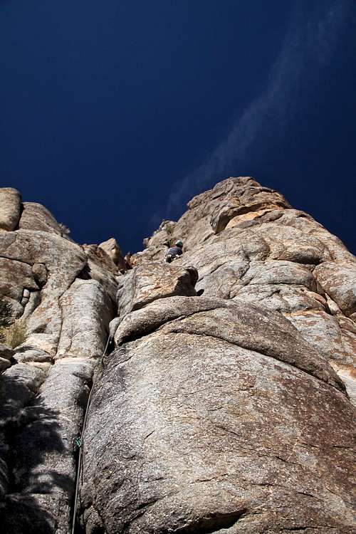
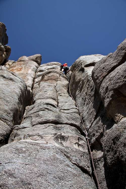
Rainbow from Sunday Wall![Sweet Sunday Serenade 5.9 III]() Sweet Sunday Serenade 5.9 Though virtually unknown as a rock climbing area, Unaweep holds great potential for new routes. Sheer rock cliffs ranging from 150 to 1000 feet in height line both sides of Highway 141 for over 25 miles. The granite/gneiss rock is generally very good to excellent and offers exceptional crack climbing as high-quality face routes. Unaweep Canyon has been primarily developed as a traditional climbing area, but the popularity of bolt protected face routes is increasingMOTHE L
Sweet Sunday Serenade 5.9 Though virtually unknown as a rock climbing area, Unaweep holds great potential for new routes. Sheer rock cliffs ranging from 150 to 1000 feet in height line both sides of Highway 141 for over 25 miles. The granite/gneiss rock is generally very good to excellent and offers exceptional crack climbing as high-quality face routes. Unaweep Canyon has been primarily developed as a traditional climbing area, but the popularity of bolt protected face routes is increasingMOTHE L
 |  |  |
Location
Unaweep Canyon is located in western Colorado, nearly on the border with Utah. From Grand Junction drive south about 8 miles on US Highway 50 (or drive north from Montrose and Delta on US 50) to Whitewater. Turn west here on Colorado Highway 141 and continue up into the canyon. Highway 141 winds through the canyon for over 25 miles.State Highway 141 follows Unaweep Canyon between Whitewater and Gateway, and is part of the Unaweep Tabeguache Scenic BywayRock Climbing
 Rainbow from Sunday Wall
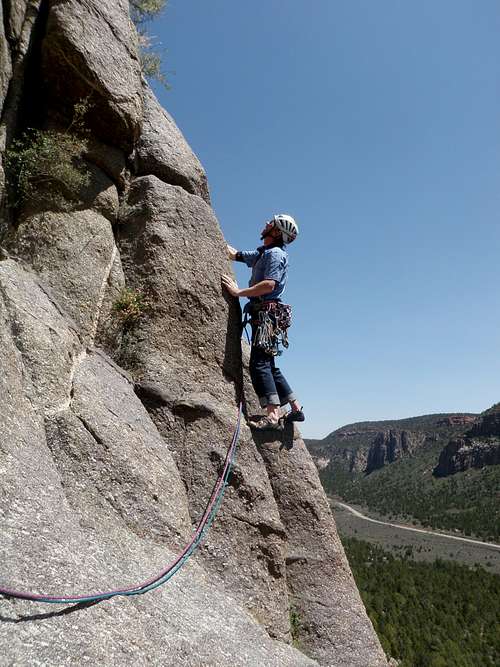 Sweet Sunday Serenade 5.9
 There are over one thousand routes currently developed, and more to be discovered. Hidden Valley, Fortress, Quarry, and Juniper Walls along with the Mother Buttress provide the highest concentration of good crack climbing. Sunday Wall, Cave and Mother Buttress provide the highest concentration of bolted face routes.
Situated at an elevation of 7000 feet, Unaweep has a semi-arid climate with a typical climbing season lasting from March into December (although I found an access trail full of snow in March). With the general east/west orientation of the canyon, walls on the north side of Highway 141 provide sunny climbing during cooler months, while walls on the south side of 141 provide shade during the hot summer months.
The potential for many first ascents is unlimited, but climbers must respect the rights of private property owners. ![Cow-a-Bunga 5.8]() Cow-a-Bunga 5.8Fortress. It could be sufficient for a quick introduction to Unaweep.
Cow-a-Bunga 5.8Fortress. It could be sufficient for a quick introduction to Unaweep.
 Cow-a-Bunga 5.8
Mention of some of the more popular walls with easy access:
QUARRY WALL: The majority of climbing is on BLM land, a few climbs on private land. Quarry Wall offers some of the best rock and crack climbing in the area. Turn on the Divide Road, 13.6 miles southwest of Whitewater on Highway 141. Drive about 1.1 miles on Divide Road to the top of the last switchback.The road flattens and after another 0.8 miles look for a cairn on the right side of the road, and red flagging near the top of a small pine tree. Park and walk north approximately 125 feet to the edge of the wall, then down climb onto a ledge with a rappel chain secured around a tree.Rappel 75 feet to a 2 bolt chain anchor, then 150 feet to the ground and the start of "Sidewinder". There are more than 20 routes ranging from 5.7 to 5.11.
HIDDEN VALLEY: The majority of climbing is on BLM land, a few climbs on private land. Quarry Wall offers some of the best rock and crack climbing in the area. Turn on the Divide Road, 13.6 miles southwest of Whitewater on Highway 141. Drive about 1.1 miles on Divide Road to the top of the last switchback.The road flattens and after another 0.8 miles look for a cairn on the right side of the road, and red flagging near the top of a small pine tree. Park and walk north approximately 125 feet to the edge of the wall, then down climb onto a ledge with a rappel chain secured around a tree.Rappel 75 feet to a 2 bolt chain anchor, then 150 feet to the ground and the start of "Sidewinder". There are more than 20 routes ranging from 5.7 to 5.11.
FORTRESS WALL: The approach is the same as for Hidden Valley Wall. Both walls are adjacent to each other, Hidden Valley faces wet and Fortress Wall faces south. Approach time: 20 minutes. Excellent crack climbing. The book describes at least 8 routes, mostly 5.10s.
 Welcoming Party 5.7+
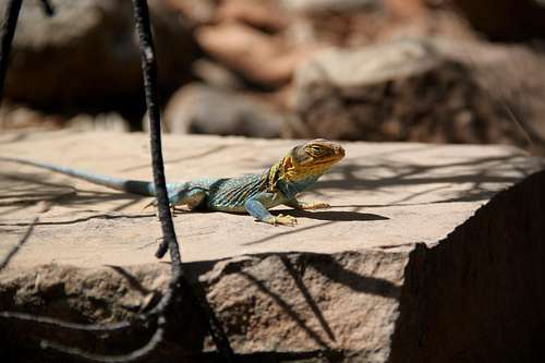 Collared lizard
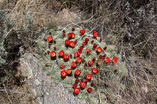 Blooming cactus
MOTHER BUTTRESS: Private property, 3.1 miles west of Divide Road on north side of Highway 141. Fortunately, two local climbers own the portion of the cliff containing nearly all of the established routes, and they are graciously allowing access time at this time. They desire to maintain open access as long as climbersrespect their property and leave no trace. Approach time: 10 minutes. This 500 to 650 feet cliff contains the highest concentration of routes in Unaweepwith several classic lines, both crack and face. One of the first crags developed in the canyon, should not be missed.The book describes more than 50 routes from 5.7 to 5.10s. Mothers Buttress on SP
TWIN OWLS: 4.4 miles west of Divide Road on the north side of Highway 141, on private property. Bob and Lisa, both experienced climbers, own a log cabin directlybelow this formation and have pioneered all the routes in the area. They are the envy of every climber who has ever dreamed of having their ownprivate cliffs in their backyard. They have developed an approach trail through their property and ask the climbers use the designated pullout and stay on the trail. Park at the pullout located 0.25 miles east of mile marker 135 on the north side of the Highway 141.Twin Owls is a small formation 100 yards east of The Beehive on BLM land. A large horizontal white dike crosses the formation at 2/3 height.The book describes a 2 pitch climb to its top.
THE BEEHIVE: The parking is the same as for Twin Owls, the approach trail is well marked, and there are signs for The Beehive.Thanks to the owners of the private property, please respect them by keeping the area clean. The book describes only one established route - Daffy Duck Pinnacle 5.9, 2 pitch climb.
LOWER SUN TOWER: Located on private property, directly above mile marker 135 on the north side of Highway 141. A large notch separates lower and upper Sun Tower.The best approach is the same as for The Beehive. The owners=climbers of the log cabin by the parking area developed a beautiful approach trail.There are 4 established routes there: 5.6 to 5.9, and one of my favorites: Dovencourt.
UPPER SUN TOWER: Approach from the pullout by the log cabin, 0.25 miles east of mile marker 135. The approach trail is well marked, please respect the land owners. The book describes 2 lovely multi-pitch climbs to the top of the formation: 5.6 Betty and Ray's Adventure, and 5.7 Claret Cup Crack.
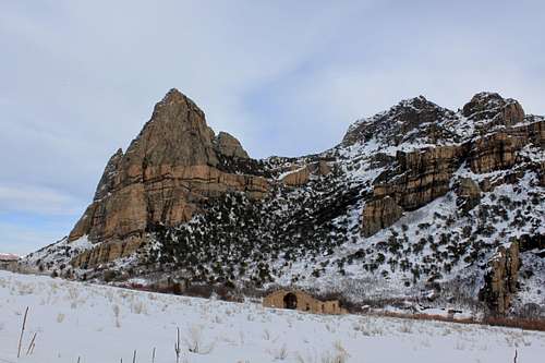
THIMBLE ROCK: Private property located 13.0 miles west of Divide Road on the south side of Highway 141. The Craig ranching family owns the largest portion of private land in the canyon, and so far they have allowed access to the cliffs on their property. Situated in one of the most beautiful and picturesque spots in Unaweep Canyon,this 900 foot monolith stands guard over the historic Driggs Mansion and surrounding valley. Approach the wall by first driving a short distance west (about 0.25 mile) to Driggs Mansion, a stone ruin below Thimble Rock with a large pullout and interpretive sign. At the east side of the pullout is a dirt road which angles off to the east at 45 degrees. Take this road and drive a short distance along the fence to a gate and park, then make a direct 10 to 15 minuteapproach to the base by foot. The book describes 2 routes: Trail of the Serpent 5.10+, 7 pitches, and Tail of the Serpent 5.10-, variation of the previous one.
UNAWEEP WALL: Situated near the western extent of Unaweep Canyon, this beautiful wall is located approximately 23.5 miles west of Divide Road on the north side of Highway141. It is also located about 9.0 miles east of Gateway, and 10.5 miles west of Thimble Rock. It lies within BLM boundaries. At 1300 feet in height, Unaweep Wall is the largest rock face outcropping in the canyon. The book describes only one route: "Ancient Wisdom", rated as 5.11- A3+, 10 pitches.
Bouldering
 Bouldering with kids
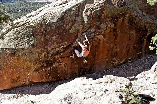 Boldering in Unaweep is limitless
Another good bouldering spot is located just east of mile marker 149 with several campsites. The obvious large boulder just off the highway (easily identified with chalk marks) has several fragile dinosaur bone imprints on its east face. There are really thousands of boulders scattered around. A bouldering paradise!
Ice climbing
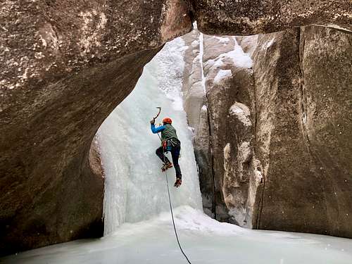 Snyder Falls
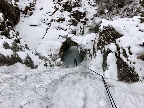 Snyder Falls
Snyder Falls WI3: great for beginners, the setting is very scenic, climbing easy, fixed anchors, typically done as a 3 pitch climb. First pitch short WI2 (could be soloed), it is narrow. 2nd pitch - go underneath a rock arch and climb WI3, nice a wide. Anchors on climber's left. 3rd pitch - short with steps of WI3 and easier sections in between.
Descent: rappel the route. 60 meter rope sufficient.
Red Tape
 along the trail
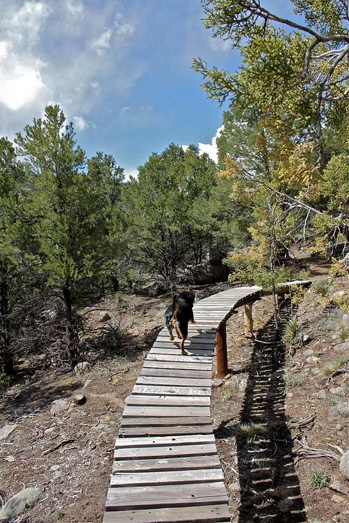 Approach to Lower Sun Tower
Please avoid walking on private property on the bottom of the canyon.
In 1990s, the Access Fund responded to the concerns of local climbers by donating money to buy 56 acres containing two most popular cliffs, Hidden Valley and Sunday Walls. The Access Fund later purchased Fortress Wall and constructed an access trail across private property.
The Access Fund is a national, non-profit organization dedicated to keeping climbing areas open and conserving the climbing environment. You can support this organization.
Access Fund Link
![A rarity]() A rarity - divide in the middle of the canyon
A rarity - divide in the middle of the canyon![Duchess surrounded]() Duchess surrounded by wildflowers
Duchess surrounded by wildflowers![Driggs Mansion]() Driggs Mansion
Driggs Mansion![Driggs Mansion]() Driggs MansionOne of the most historic sites along the Scenic Byway in Unaweep is the Driggs Mansion, a stone ruin located just west of majestic Thimble Rock. The mansion was built around 1915 by Lawrence K. Driggs., a wealthy New York lawyer. The structure was considered lavish for its time and was reportedly built for his future bride to be, who apparently refused to live in such wild and desolate isolation. The abandoned structure later became the Chateau Thimble Rock, a hunting lodge, and eventually met its demise through vandalism.
Driggs MansionOne of the most historic sites along the Scenic Byway in Unaweep is the Driggs Mansion, a stone ruin located just west of majestic Thimble Rock. The mansion was built around 1915 by Lawrence K. Driggs., a wealthy New York lawyer. The structure was considered lavish for its time and was reportedly built for his future bride to be, who apparently refused to live in such wild and desolate isolation. The abandoned structure later became the Chateau Thimble Rock, a hunting lodge, and eventually met its demise through vandalism.
Camping
Please don't camp on the private bottom land in Unaweep Canyon.From the intersection of Highway 50 and 141 at Whitewater, drive 1.4 miles southwest on 141 to the head of Lower East Creek Canyon. BLM public land starts here and continues for 6.3 miles to the top of Nine Mile Hill. Many good camping sites (as well as great bouldering) are available between these two points.
The nicest and most available camping in Unaweep Canyon is located off Divide Road on BLM land, and in the adjacent Uncompahgre National Forest. From the intersection of 141 and 50, drive southwest towards Gateway for approximately 13.6 miles. Just past a ranch house, look for a sign "National Forest Access, Divide Road - Uncompahgre Plateau". Turn left (east) and drive about 2.1 miles to a cattle guard and BLM sign. Several nice camping sites are available along the road.
Geology
The Precambrian metamorphic rock that forms the cliffs in Unaweep Canyon are some of the oldest in Colorado, dated at 1.4 to 1.7 billion years old. Most of the rock is a low grade metamorphic granite/gneiss, although a few areas of younger granitic intrusive rock is present. This is especially evident at Juniper, Quarry, and Divide Walls, where the rock is of exceptionally high quality and would be generally classified as a quartz monzonite.The canyon began forming some 300 million years ago during the Uncompahgre Uplift and now displays a great unconformity, with Triasic red rocks lying directly on top of the Precambrian granite and metamorphic rocks. Cretaceous Dakota Sandstone forms the walls of Lower East Creek Canyon and provides excellent climbing and bouldering in these areas.
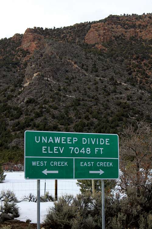
Unaweep Divide
 A rarity - divide in the middle of the canyon
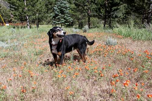 Duchess surrounded by wildflowers
Unaweep canyon cut across the Uncompahgre Plateau in western Colorado: two creeks flow out of the canyon, East Canyon Creek and West Canyon Creek, separated by Unaweep Divide nearer the east end of the canyon. There are multiple explanations for one canyon have two outflow creeks. One explanation holds that in ancient times, the Dolores River flowed through Unaweep and into the Gunnison River south Grand Junction. A second explanation is that the Gunnison River itself once flowed through the canyon. The uplift of the Uncompahgre Plateau between 5 and 15 million years ago resulted in the course change of the river involved and left the canyon without a river.
A little history...
 Driggs Mansion
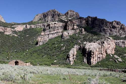 Driggs Mansion