
-
 6848 Hits
-
 79.04% Score
-
 10 Votes
|
|
Route |
|---|---|
|
|
37.99777°N / 107.79534°W |
|
|
Hiking, Scrambling |
|
|
Summer |
|
|
Half a day |
|
|
Strenuous |
|
|
Overview
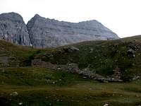
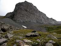
At least five ranked 13ers rise above the upper basin west of Lower Blue Lake in the Mount Sneffels Wilderness. The view of these peaks from Blue Lakes Pass is stunning to say the least. It is one of my favorite views in all of Colorado.While stunning from a distance, if you get the opportunity to get a closer look you will find that these peaks are composed of the steep, loose rock that the San Juans are notorious for. The basin itself is a barren landscape, albeit loaded with quite colorful rock, so even up close the peaks have a certain charm.

We weren’t able to summit any of these peaks so this route just describes how to reach the upper basin and an elevation of 12,700 feet, which will put you at the base of these 13ers. And as of this writing none of the five peaks pictured below have Mountain pages on SummitPost.
 West Dallas 13,741 ft |
 T0 13,735 ft |
 S4 13,242 ft |  S3 13,410 ft, S5 13,380 ft |
Route
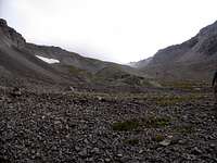
From the Blue Lakes Trailhead hike 3.3 miles to reach Lower Blue Lake. There is 1,600 feet of elevation gain to Lower Blue Lake.From Lower Blue Lake there is no defined trail or route to reach the upper basin. There is nothing technically difficult in reaching the upper basin although the initial hike up the grass slopes is steep. The key is to just avoid as much of the steeper sections of grass on the lower portions and then avoid as much of the loose rock that lies above.
There is 1,700 feet of elevation gain from Lower Blue Lake to near the base of the east ridge of S3, which lies at 12,700 feet. We did not use a GPS so I don't have exact mileage from Lower Blue Lake to the upper basin. Our ascent time was 1.5 hours, and I don't consider myself a particularly fast hiker.

There are two inlet streams that drain into Lower Blue Lake from the upper basin. Staying closer to the south stream instead of the north stream makes for an easier ascent route. To reach the south inlet stream follow the trail to the south end of Lower Blue Lake. A faint trail will lead around a corner, where the south inlet stream will come into view. It’s hard to miss and is rather pretty. Stay north (right) of this stream and start blazing your own path up through the grass and rocks.
 Stay right of stream | 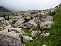 |
You can also head up the basin by staying closer to the north inlet stream, on its south (left) side but we found this way to be steeper, had fewer good rocks for foot placement and also requires some bushwhacking on the lower slopes.
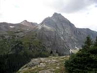
As you head up the grassy slope a small peak will come into view that looks like a shark's fin, which is the direction you want to head. Just below this "shark’s fin" and to the north (right) the terrain levels out. Start heading right on a relatively flat bench to the north side of the shark’s fin. While it is possible to reach the upper basin by going left at the "shark's fin", the route is nothing but loose San Juan rock with some steep sections. While distance wise it may be a shorter hike if you are heading to T 0 it will most likely take longer due to the lousy footing.
 "Shark's Fin" |  Terrain to the south |
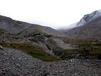
Once on the north side of the shark’s fin continue up in a north westerly direction. There is a steep ridge branching off to the north from the tail of the fin. This ridge contains plenty of loose rock. Friendlier, more stable terrain lies to the northwest. As we veered northwest we got closer to but never crossed the north inlet stream.
Again there is no trail and no cairns on the entire route so you will have to choose the best path. The area is completely open and we found the going to be pretty straightforward. There are a number of options and FYI, on the descent, don’t veer too far north as you will cliff out!
 |
 |
 |
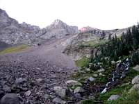
As you continue up the basin S3 and S5 will come into view. The path of least resistance is to head towards the east ridge of S3. When you finally reach the upper basin the east ridge of S3 will be right in front of you, and from there you can decide which of these 13ers you want to go for.
 |  |
Getting There
Per Gerry Roach - Go west on Colorado 62 for 4.8 miles from the US550-Colorado 62 junction in Ridgway. Ridgway is 11 miles north of Ouray. Turn south onto Ouray County 7 (East Dallas Creek Road) and measure from this point. Go south on Ouray County 7 (dirt), stay left at 0.3 mile, stay right at 2.0 miles and enter the Uncompahgre National Forest at 7.2 miles. Stay right and cross East Dallas Creek at 8.2 miles. Take the middle of three forks at 8.8 miles and reach the trailhead after 9.0 milesThe road is in good condition and a 4WD or a high clearance vehicle is not needed.
Camping
There are excellent backcountry campsites in the woods west of Lower Blue Lake.Essential Gear
No special gear is needed to reach the upper basin. If you choose to try and climb one of these peaks a helmet would be highly recommended.I only listed this for a summer climb as I do not have any information regarding conditions in snow. If you have information on conditions in the spring, fall or winter please add a comment in Additions/Corrections,