
-
 50353 Hits
-
 92.59% Score
-
 39 Votes
|
|
Area/Range |
|---|---|
|
|
37.99777°N / 107.79534°W |
|
|
Hiking, Mountaineering, Ice Climbing, Scrambling, Skiing |
|
|
Spring, Summer, Fall, Winter |
|
|
Overview
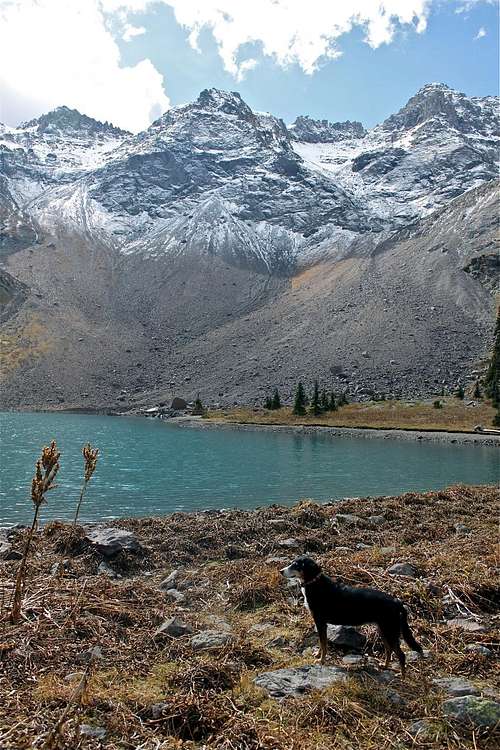

Blue Lakes are set in a scenic glacial basin within the 16,505 acre Mount Sneffels Wilderness. In addition to a beautiful hike, the fishing in all three lakes can be superb. But, don't ask me about fishing - I cannot kill a fly.
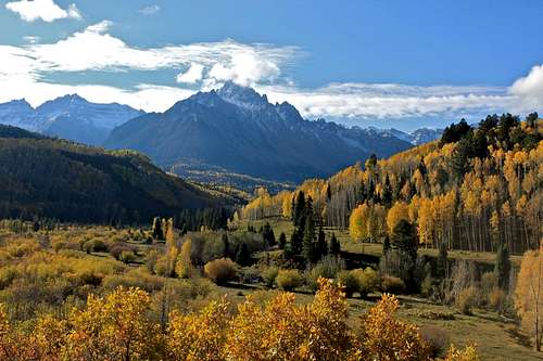
There are three lakes, and especially the middle and upper Blue Lakes provide the best views of the surrounding collection of rugged summits. Included in the lineup are 13,809 foot Dallas Peak and 13,694 foot Gilpin Peak to the south, and unnamed 13,242 foot high extension of Mears Peak to the west, and the tallest of all 14,150 foot Mount Sneffels directly east.
The Lowest Lake = the first one approached from the Blue Lake Trailhead is the largest one. There are several beautiful campgrounds located along its shore. There are plentiful trees, and the scenery is splendid. The hike to the lowest lake is only 3.3 miles, and the elevation is 10,980 = 3347 meters. The elevation gain from the Blue Lake trailhead is 1.600 feet = 488 meters.
The Upper Lake has elevation 11,720 feet =3572 meters, and the distance between the Upper and Lowest Lake is about 0.9 miles.
The Middle Lake is the smallest.
The hike is easily done as a day hike, and you can visit all 3 lakes. The hike is easier via the Blue Lake Trailhead - distance of the round trip around 8 miles. The hike from Yankee Boy Basin could be much shorter, depending where do you park, but you have to negotiate much rougher terrain, and go over the Blue Lake Pass, elevation 13,000 feet = 3962 meters.
I hiked it both ways, and enjoyed both hikes very much.
The best comprehensive view of all lakes is from the summit of Mount Sneffels, which could be a nice side trip.
Getting There
You can hike here from 2 different trailheads:
1. from Yankee Boy Basin
2. from Dallas Creek Road
Yankee Boy Basin - drive from Ouray south on 550, turn right onto Camp Bird Mine (CR 361). Follow the directions for Yankee Boy Basin. You need a high clearance 4 WD vehicle on this road. There are several parking options along this road, but you can drive all the way up to Yankee Boy Basin Trailhead. I chose to park below and hike via Wright's Lake, and then continue on the trail pass Wright's Lake towards Blue Lake Pass. The views are spectacular. You do need a 4WD and high clearance vehicle to get to higher sections of Yankee Boy basin.
Dallas Creek Road - from Ridgeway drive west on Colorado Highway 62 (towards Telluride), turn left onto Dallas Creek Road (FR 851) and drive 14 miles south to the Blue Lakes Trailhead. This road is in a very good condition, and you do not need 4WD or a high clearance vehicle. You can see amazing views of Mt. Sneffels, and especially in the fall with golden aspens and snow covered peaks the drive is spectacular!
Approach from Yankee Boy Basin


You can drive up to a very high altitude and park nearly below Mt. Sneffels, however most vehicles do not get so high. The road get rougher higher you get. I believe that the parking lot below Mt. Sneffels is 12,000 feet high! I drove there twice - once when I tried to get my son to the summit of Sneffels, and 2nd time when I tried to get my brother to the same summit - we were successful both times, but then the hike from there is very short. This is off the subject, but per Colorado fourteeners rules, you need to have at least 3,000 feet of elevation gain to count fourteener as a summit (so, officially neither of them summited).
I usually stop near the restroom, or a little bit above, and hike up along the dirt road - there is a shortcut trail towards the Wright's Lake - well signed. The Wright's lake is a nice alpine lake, offering great views. It does tend to have some people in the summer, but if you visit in off season, there is nobody there. The path is usually covered in the snow until mid June.
The trail above the Wright's Lake is well travelled, and you can see all the way to the Blue Lake Pass. It is a little bit steep and exposed). The views of Mt. Sneffels are amazing. The top of the pass is just about 13,000 feet, and from there you will get a wonderful view of Blue Lakes. The trails down towards the lakes is steep at some sections with many switchbacks.
Blue Lake Pass


Blue Lake Pass is 12,980 feet, and is a very scenic place surrounded by many beautiful peaks. The photo on the left shows Blue Lake Pass from the Yankee Boy Basin, and the photo on the right shows it from the Blue Lakes side.
Southwest Ridge 3rd Class Route on Mount Sneffels starts at the Blue Lake Pass too - you leave the trail at the Blue Lake Pass and climb the ridge toward Mt. Sneffels. Easily bypass some jagged pinnacles low on the ridge on the ridge's west (left) side. Once you are past pinnacles, climb into a prominent, 13,500 foot notch on the ridge crest north of the pinnacles. From the notch, climb a south-facing gully leading to the upper ridge (class 3). There is considerable exposure on the ridge's west side.
Approach from Dallas Creek Trailhead


You drive up on a good Dallas Creek dirt road to the end. There is a small parking lot, and an obvious sign for Blue Lakes Trailhead. The trail is easy to follow, it gradually climbs up over 1600 feet until you reach the Lower Blue Lake. The distance is 3.3 miles. First section of the trail goes along the East Fork of Dallas Creek, there will be a beautiful waterfall on this creek higher up.
There is more steep trail between the Lowest and the Middle Lake, but the hike is definitively worth it. The views of the Lowest lake from this section of the trail are spectacular. The climb in the last 1/4 mile to the uppermost Blue Lake is negligible.
And if you had not enough hiking, you can continue up the Blue Lake pass - see illustration above, and climb Mount Sneffells.
Peaks from Yankee Boy Basin
| Summit | A few words about the mountain | ||
| Mount Sneffels |
 |
Mount Sneffels has a Nordic name meaning snowfield, which Jules Verne used in his Journey to the Centre of the Earth. It was given to the peak by Endlich and companions at the time of the 1874 first ascent. There are several routes going up Mount Sneffels, starting from Class 2+ South Slopes route to class 3 scrambles. | |
| Kismet |
 |
Kismet is the cluster of points SE of Mount Sneffels. Most people climb it either from Dyke Col between Kismet and Cirque Mountain, or a route straight from the Wright's Lake. | |
| Gilpin Peak |
 |
Gilpin Peak is usually climbed from the Yankee Boy Basin, aim for the main ridge descending south from the summit. A more complicated route is from Blue Lake Pass. | |
| Cirque Mountain |
 |
Cirque Mountain is 1.2 miles east of Mount Sneffels. It has a gentle west ridge. The prominent cliffs when viewed from the north give obvious significance to the mountain's name. Best climbed from Dyke Col. My album | |
| TeakettleMountain |
 |
Teakettle Mountain continues the range summits east of Mount Sneffels. The standard approach is from the little parking lot by the restroom in Yankee Boy Basin. There is no official trail, and expect a lot of loose scree. My album | |
| Coffeepot |
 |
Coffeepot is a little protruding knob named S1, today mountaineers call it comically as the Coffeepot. People often climb it together with Teakettle, or Potosi. | |
| Potosi Peak |
 |
Potosi Peak is the southeast termination of the Sneffels range crest. Potosi has a formidable looking summit block, and is more easy to climb from the east, where there is a break in the cliffs. |
Peaks from East Dallas Creek/Blue Lake Access

The northwest section of the Sneffels Range is approached via Blue Lakes and Blaine Basin from East Dallas Creek Road. The same peaks that are accessible from upper Yankee Boy Basin are feasible via Blue Lakes, i.e. Sneffels, Gilpin etc, although Sneffels, from this approach, is a much more formidable looking mountain.
Accessible from the upper 1.2 miles west of lower Blue Lake, S3 (13,410') and S5(13,360') rise on the divide crest. The summit of S4 (13,242') is perched on a ridge extending 0.5 mile east from S5, and is also accessible from the basin west of the lower lake. The San Juan Mountaineers designated S4 as Wolcott Mountain.
S6 (13,441') is a peak of several craggy summits offering good bits of climbing on the main divide crest 0.2 mile northwest of S5, and connecting 0.5 mile north with Wolcott. T0 (13,735') is 1 mile southwest of S3 on the divide bend, and likewise accessible from the lower lake with a longer walk up the cirque.
Dallas Peak (13,809') - the standard route is up the mountain's east face, and the standard approach is from the Telluride side, thereby avoiding the cliffs south of Blue Lakes. However, early in the summer the mountain is often climbed from Blue Lakes on snow all the way to the low point of the east ridge. From there follow the ridge, swinging south around any obstacles, and finish by the standard route.
Dallas Peak
Red Tape

There are no fees for parking or camping in the area.
Yankee Boy Basin used to be a fee area - not anymore, but camping is still not officially allowed - only in campgrounds. I did sleep in my car just below Mount Sneffels in the past.
The Blue Lake areas offers plenty of beautiful backcountry camping opportunities.
Fishing in the lakes - you need to buy a permit.
And, I did not find anything against pets.