
-
 11982 Hits
-
 84.27% Score
-
 18 Votes
|
|
Canyon |
|---|---|
|
|
Hiking, Scrambling |
|
|
Spring, Fall, Winter |
|
|
Overview

An indisputable wonder, Upper Muley Twist Canyon is on many a hiker and guidebook's short list of the very best day hikes in Utah, where there is no shortage of spectacular day hikes. The established route, which combines the canyon with a trek along the crest of the Waterpocket Fold above, is mostly a hike with a little bit of easy scrambling, but there are options for canyoneers and scramblers to go exploring. One such possibility would be where the canyon route begins ascending to the rim in order to bypass the canyon's narrows. The route eventually passes just above the very head of the canyon, but a canyoneer could opt for following the canyon itself to that point (the narrows are not long, and I do not know if they are technical).
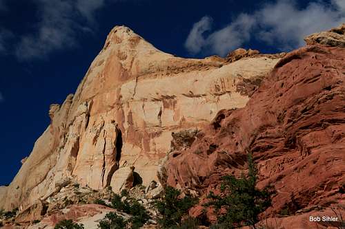
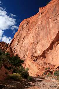
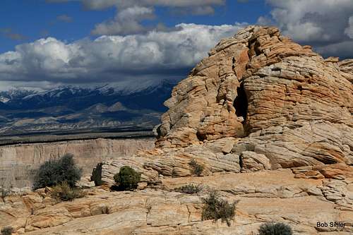
The scenic highlights of the canyon are probably its eight sandstone arches, three along the rough access road to the trail itself and five further upcanyon, but the canyon walls and pinnacles within the canyon are worth attention, and the far-ranging views from atop the Fold complement and contrast the canyon scenery below. Those far-ranging views include the length of the Henry Mountains, the last major range in the Lower 48 to be mapped and still quite remote by today's standards.
The name: "From 1881 to 1884, the canyon served as a wagon route for Mormon pioneers traveling south toward San Juan County. The canyon was thought to be narrow enough to “twist a mule” hence the name Muley Twist."
Source
Formerly, there was a page for this canyon, complete with a climber's log and about a few dozen photos, but the author deleted that page. Attached to that page was this trip report that I wrote, and it contains numerous photographs as well as commentary on the route. Rather than chop that trip report up or replicate it here, this page will stick to the nuts and bolts of visiting Upper Muley Twist Canyon.
Getting There
No matter what, it is a long drive in. This is a good thing. If it were a short, easy drive, the canyon would be mobbed most of the time.On UT 24, just about at the eastern boundary of Capitol Reef National Park, turn south onto Notom-Bullfrog Road. Drive this road, which becomes a 2wd dirt road after about five miles (impassable when wet), for 33 miles to an intersection with the Burr Trail. Turn onto this road and ascend the switchbacks that yield increasingly spectacular views. A little after three miles, turn right onto a dirt road signed for Upper Muley Twist Canyon. If you have a low-clearance vehicle, park soon after this.
With high clearance, you can nearly five miles from what would be a hike of more than 14 miles. The road is rough but not difficult for the next 2.4 miles to the parking area at the trailhead.
Another way to approach is from Boulder, along UT 12. Follow the Burr Trail east from town. The road is paved for 31 miles, sometimes steep and often winding, to the border of Capitol Reef National Park, and from there it becomes a 2wd dirt road. A little over two miles past the park boundary, look for the turnoff for Upper Muley Twist Canyon.
Route
Key Points and Distances:* 2.4 miles from 2wd parking to start of actual trail
* 1.8 miles to junction of Canyon Trail and Rim Trail
* 3.1 miles to where the trail leaves the canyon behind for good and climbs in earnest to the rim
* 2.7 miles along the Rim Trail back to the Canyon/Rim Trail junction
* 1.8 miles back to official trailhead
* 2.4 miles back to 2wd parking
Elevation gained is around 1000'.
 |
 |
 |
Highlights:
* 2wd parking to trailhead-- Whether you hike or drive this stretch, take some time to stop and smell the roses, or see the arches. There are three arches to see. The first, near the beginning, is Peek-a-boo Arch, practically a slit in the yellow sandstone. Double Arch, which, as the name implies, has two spans, is next, and an unnamed one is third. Peek-a-boo Arch is on the east side of the canyon (and the only one of the eight arches on the east side); the other two, though large, are easy to miss if you are the driver.
 Peek-a-Boo Arch Peek-a-Boo Arch |
 Double Arch Double Arch |
* Trailhead to narrows-- Enjoy the pinnacles, walls, and arches (five of them). Only one arch, the second one, has a name (Saddle Arch). It is massive and pink and is just before the junction with the Rim Trail; it can be approached with a little clambering, and intrepid scramblers might make it up the steepening sandstone to stand directly beneath it. The first arch is also very large. The third and fourth are higher up on the canyon walls and would be difficult to reach, but the fifth, just yards away from the start of the narrows, is close to the ground and the easiest of all five to access. It is at the mouth of a short slot canyon joining the main one, and although it can be easy to miss, it is also easy to see.
 First arch First arch |
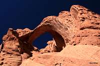 Saddle Arch (second arch) Saddle Arch (second arch) |
 Third arch Third arch |
 Fifth arch Fifth arch |
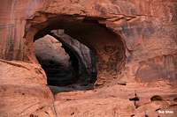
As noted, the narrows begin shortly after the fifth arch. If you reach the narrows, backtrack a little and look for cairns on the east (right) side marking a way to climb up and around the narrows. The route does not yet make its ascent for the rim above; that comes after some climbing and skirting to the head of the canyon.
 Entrance to narrows
Once the trail reaches the crest of the rim, also the crest of the Waterpocket Fold, enjoy the gentle journey and the sweeping 360-degree views. If you seem to lose the exact way, look around for cairns. Although there do seem to be other ways to return to the canyon floor, you really do not want to miss the trail when it descends to it.
Red Tape
No fees. Observe Leave No Trace ethics.There is no water along the route.