A Second Chance
After summiting all of the peaks I really wanted to do in the Wasatch, besides trying out some of the more obscure hikes in Veranth’s “Hiking the Wasatch” book with my wife and son, I was interested in going back to a few classics I hadn’t done in a while. I guess I’m like a lot of people I’ve met in Utah who aren’t as interested in peak-bagging lists. Whether this is due to the abundance of quality hikes in the state that don’t necessarily lead to summits or some form of ADD that always causes me to start looking into interesting peaks in other ranges and states, I’m not sure. There were a few other Wasatch range peaks I wouldn’t mind trying out sometime in the future (Ben Lomond is one that comes to mind), but with them I wasn’t in as much of a rush since I’d already hiked/climbed the larger peaks visible above Salt Lake City and Provo.
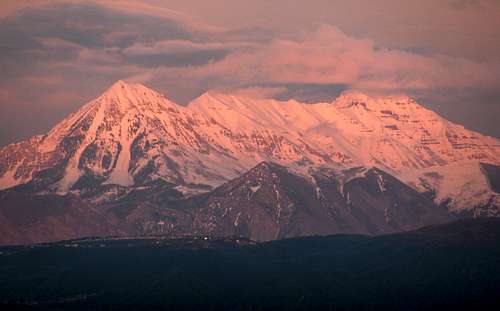
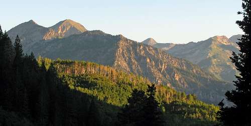
![Timpanogos Alpenglow]() Alpenglow on Mount Timpanogos
Alpenglow on Mount Timpanogos
The previous year I had hiked Mount Nebo a second time, and with my father and two younger brothers in town I thought it would be a great time to introduce them to Mount Timpanogos, which most people consider the best hike in the state of Utah and one of the best hikes in the Rocky Mountains. Hiking Timpanogos via the Timpooneke Trail was the very first Wasatch hike I ever did, and my first hike to a relatively difficult summit (Gebel Musa in the Sinai Peninsula was the only other one before that, but it was much shorter and easier), so I felt I was overdue for a re-visit.
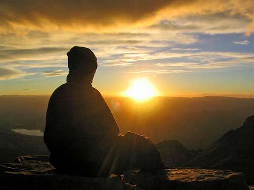
![Brandon admires the sunrise...]() Mount Timpanogos sunrise hike (9/18/04)
Mount Timpanogos sunrise hike (9/18/04)
My friend and I actually hiked up the peak as a spur-of-the-moment idea at a late-night pizza party on a Friday night late in September. Our relatively fast pace (despite a route-finding hiccup at the beginning, we made it to the saddle in under 2 hours, in an attempt to not be outdone by a girl in our group who was on the BYU cross country team) got us to the top well before sunrise, and after watching the sun come up we went back down almost as fast. Because of this, I missed out on some of the great scenery on the trail and had a somewhat skewed perspective of the mountain. When debating which was my favorite hike or climb in the Wasatch I would always advocate for Pfeifferhorn being the better hike of the two, and could not understand why most people always said that Timpanogos was the best.
![]()
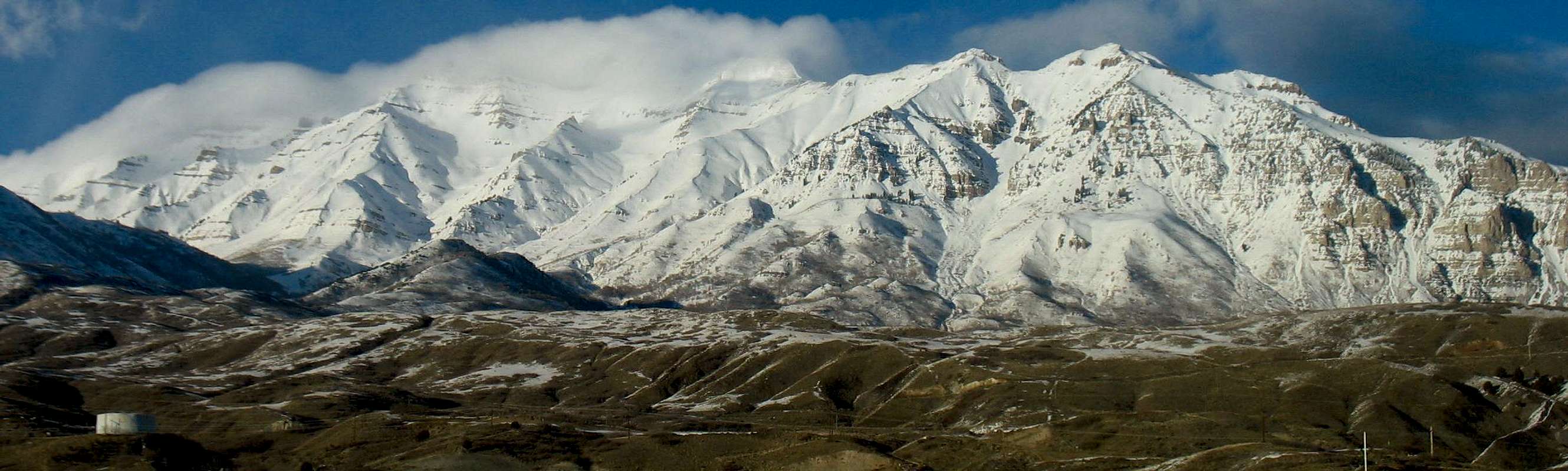
Mount Timpanogos from Orem
Starting the hike at a more reasonable hour would give me the chance to see what I had missed out on the first time, and this time I was also planning on taking the loop approach by descending via the snowfield/glacier to add some more variety to the hike. For awhile I thought about a car shuttle with a descent down the Aspen Grove Trail, but since my Dad had never been on a big hike with us before (my brothers had done Mount Sneffels with me in Colorado the year before) I thought it would be best to spare his knees and the extra driving by going back down the same way on the less-steep Timpooneke Trail.
Waterfalls, Wildflowers, and Goats
My Dad flew in from D.C. the night before the hike (didn’t get to the house until about 11pm), but re-emphasized his desire to come on the hike and assured me that he’d be up for an early morning start, so my brother Johnny and I planned on leaving my place in South Jordan with my Dad at 4:30 am, meeting our brother Chris at the gas station at Thanksgiving Point at 5, and getting to the trailhead at 5:30. I told them that the earlier we started the more comfortable we’d be since Wasatch hikes usually involve a lot of walking under the hot sun with little cloud cover, but despite what I’d heard about parking issues I also didn’t want to start so early that we were all sleep-deprived. We got to the guardhouse at the entrance to American Fork Canyon at about 5:20, and I was surprised to find it open that early (the person there said this only happened on Saturday’s). After paying the $6 fee, I asked if she knew about the availability of parking spaces at the Timpooneke trailhead and learned that the parking lot was completely full, which I had feared. We got to the turnoff to the trailhead from the Alpine Loop road, and a ranger there was preventing cars from driving up to the trailhead. He told us we’d have to drive in the opposite direction up the Alpine Loop and park where we could find space off the side of the road, so I dropped off Johnny and my Dad at the intersection and Chris and I sped up the road looking for a couple open spots. We didn’t find any until about a mile later (had to be sure to have the tires completely off the pavement to avoid a ticket), so after parking we jogged back down to meet up with Johnny and my Dad. This wasn’t the way I wanted to start off the day, so hopefully things would go better later on.
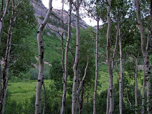
![Timpooneke Aspens]() Aspen trees
Aspen trees![Scout Falls run-off]() Scout Falls runoff
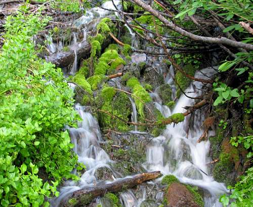
Scout Falls runoff![Timpooneke waterfalls]() Timpooneke waterfalls
Timpooneke waterfalls![Timpooneke cliffs]() Timpooneke cliffs
Timpooneke cliffs
We hiked up the road past the Timpooneke campgrounds and started hiking from the trailhead a little after 6am, with the sky still dark enough to ensure cool weather for a few more hours but light enough that we didn’t need flashlights. We almost started off on the wrong trail, but a couple guys nearby helped redirect us. Finally on the trail, we started making our way up the mountain at a decent pace, with only a short water break here and there. I had packed snacks and drinks for everyone so that they had less to worry about, and was hoping that we had enough water (a little over 2 liters for each of us). My Dad had drank an additional liter of Gatorade on the drive to the trail in an attempt to stay hydrated and acclimatize to the higher elevations quicker (was at sea-level only 10 hours earlier) which may have helped, and I was pleasantly surprised to find that he wasn’t out of breath at all. On the way up we debated the implications of Lebron James’ “Decision”, and how it would affect the NBA landscape for the next few years (we all played basketball in high school and are avid fans). On most trails I’d be too out of breath to argue about basketball, but Timpooneke is so nice and gradual that I never really felt out of breath on the way up. My Dad attributed his getting into better shape to a strict push-up regimen, which he had rigidly been adhering to for a year. It made me realize that I’d need to adopt a more regular form of exercise to offset the effects of working at a desk all day if I wanted to be in good shape when I was 50 as well.
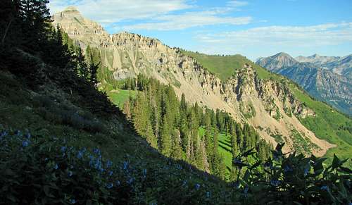
![Giant Staircase views]() "Giant Staircase" views
"Giant Staircase" views![Sunrise on Timpooneke Trail]() Sunrise on Timpooneke Trail
Sunrise on Timpooneke Trail![First light on Timpooneke trail]() First light
First light![Sunlight above meadows]() Timpooneke meadows
Timpooneke meadows
As we made our way up to the “Giant Staircase” we passed the run-off from Scout Falls several times. Higher up the staircase we started running into more and more people, giving us a preview for the crowds we’d see later on. We were almost to the top of the staircase as the sun was shining on us a couple hours later, when Johnny’s pace started to slow due to blisters. In moving his things back and forth the last month he had somehow lost track of his favorite hiking boots and had been forced to bring a newer pair that he had not yet broken in. I gave him a few band-aids, which seemed to temporarily help him a little bit, but his pace was still slow and the people we had passed earlier were now passing us. Playing leapfrog on the trail with other hikers can sometimes be annoying and awkward, but everyone seemed to be in good spirits so it wasn’t too bad. Besides the couple who felt the need to have music blaring from a giant boom-box on the trail, most everyone was kind and courteous.
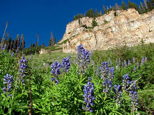
![More Timpooneke wildflowers]() Timpooneke wildflowers
Timpooneke wildflowers![Giant Staircase wildflowers]() Wildflowers below "Giant Staircase"
Wildflowers below "Giant Staircase"
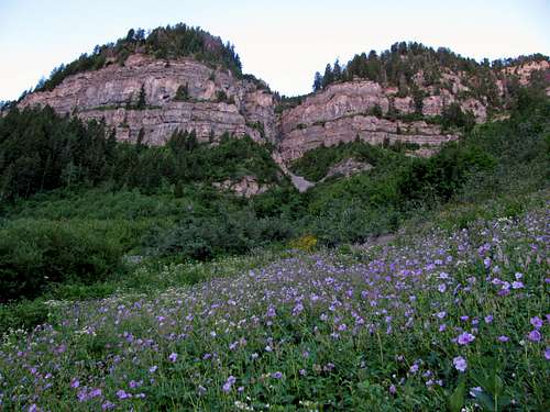
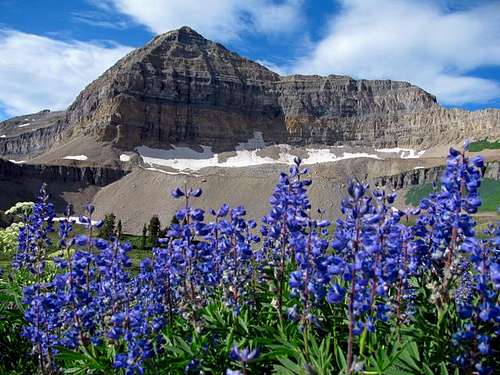
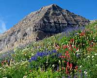
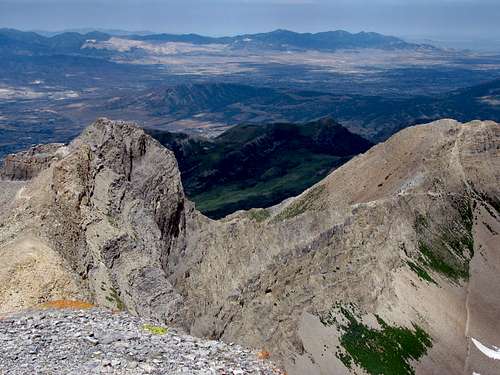
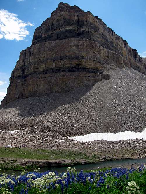
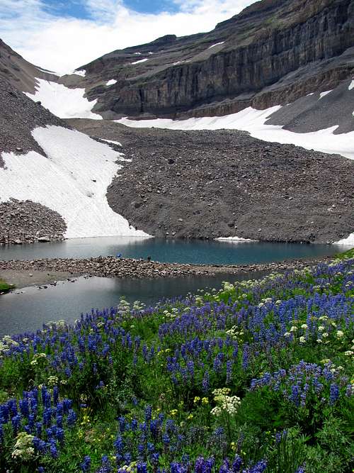
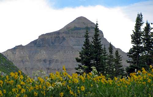
With the display of wildflowers, little waterfalls, and steep cliffs all around us I was beginning to realize why so many people did this hike. As we rounded the corner after one of the larger switchbacks, the main summit of Mountain Timpanogos came into view (before then we only briefly saw it at the trailhead), with over a thousand vertical feet of cliffs dropping from the summit down to the basin below. We continued hiking up to Timpanogos Basin, and upon arriving there we were greeted by an explosion of colors. There were wildflowers of every kind, with white, yellow, orange, pink, red, blue, and purple ones scattered throughout the basin. There was surprisingly little snow (much less than there usually is at the end of July), and it seemed that we had come at just the right time to see the flowers. They were even more impressive than the ones I’d seen in Ice Lake Basin in Colorado’s San Juan Mountains a couple weeks earlier (though we were likely there before their peak):
![Wildflowers below Timpanogos]() Timpanogos Basin wildflowers below summit
Timpanogos Basin wildflowers below summit![Bomber Peak]() Bomber Peak
Bomber Peak
Some light clouds covered up the sun as we were hiking west across the basin, giving us perfect temperatures for hiking. Johnny also seemed to get a second wind that enabled him to start hiking faster again, which could partially be attributed to either the flatter terrain or cooler weather. At the west end of the basin the trail steepened again, as the vegetation and flowers gave way to rockier, more rugged terrain. Johnny scrambled over to a rock pinnacle off of the main trail for me to get a picture of him (against the advice of Chris and my Dad), so we told him that if he felt good enough to do that then he should have enough energy to continue without his blisters being a problem. As we got closer to the ridge we spotted some mountain goats. In all my previous Wasatch hikes I had only seen them once far away on Cardiac Ridge as I was climbing the east ridge of Mount Superior, so it was nice to finally see some up close:
![Goat party]() Goat ridge party Goat ridge party | ![King of the mountain]() King of the mountain King of the mountain | ![Goat lunch]() Goat lunch Goat lunch |
|---|
![Looking up at Timp ridge trail]() Looking up at Timp ridge trail
Looking up at Timp ridge trail![Looking down at Timp ridge trail]() Looking down at Timp ridge trail
Looking down at Timp ridge trail![Timp cliff trail]() Up, up, up the stairs we go ...
Up, up, up the stairs we go ...![Steep switchbacks]() Steep switchbacks
Steep switchbacks
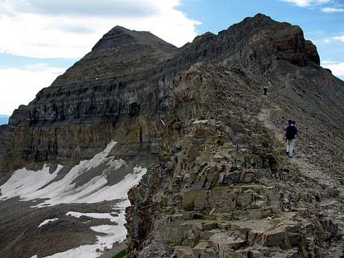
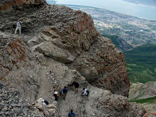
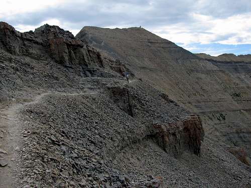
After one last long stretch of trail, comprised of several smaller rocks as opposed to an actual dirt trail, we reached the ridge where we were able to look down on Utah Valley. There were over 50 people hanging out at this spot on the ridge, so after a quick snack we continued on to get away from all of the noise. The summit looked deceptively close, but it would still take us about 45 minutes to get there. The trail led us to the base of some steep cliffs northwest of the summit, where steep switchbacks had been carved into the side of the rock. Looking up from the bottom it appears that some scrambling would be needed, but there is actually a trail that meanders all the way to the top from here. I kept walking ahead to see if my brothers and Dad could keep up, but I think the altitude was finally getting to them (for my Dad, I was surprised he’d been able to keep a fast pace for so long). We played leap-frog with a long line of other hikers gasping for air on their way to the summit, and were passed by a couple of trail runners as well as a small 7-year old boy. We finally made it to the top at around 11:15, and found a less-crowded spot to relax a couple dozen feet south of the main summit, away from the crowds by the old triangulation shack.
![Cliff trail]() Cliff trail
Cliff trail![Path to summit]() Trail to the summit
Trail to the summitThe Fun Way Down
We had some great views from the top in every direction:
![View north from Timp]() North Timpanogos to the north North Timpanogos to the north | ![View east from summit]() Emerald Lake to the east Emerald Lake to the east | ![View south from summit]() South Timpanogos to the south South Timpanogos to the south |
|---|
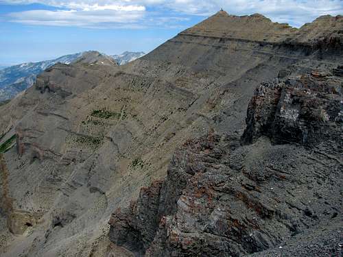
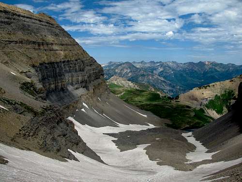
As we were eating, I scanned the snowfield leading down to Emerald Lake from the saddle between the main summit and the south summit of Mount Timpanogos. It looked like there were several dry patches, and after hearing about people getting injured by sliding over the snow when there were rocks sticking out I wasn’t sure if we should try it or not. I overheard someone talking nearby who said they had just recently done it though, and after asking him some more about it I felt more confident about trying it. After all, everyone I’d talked to who had been down the snowfield said that doing the loop was the best way to get the most out of a Timpanogos experience, so if it was safe then we were going to do it. He told us that to get to the top of the snowfield, we should make sure we went down instead of up when the trail on the ridge to the south split. He said that going up would cause us to get cliffed out, whereas the lower path would take us straight to the saddle above the snowfield. With this in mind we started hiking south along the ridge. The views down into Utah Valley were great, and my Dad was amazed when I told him that there are only a few other places in the United States where you can get this much vertical relief (over 7,000 feet) in such a short distance. We remembered the advice to take the lower path, and reached the snowfield without any problems. These are some more views we had along that section of the trail:
![Rugged Timpanogos]() Rugged Timpanogos
Rugged Timpanogos![Summit above snowfield]() Timpanogos snowfield
Timpanogos snowfield![Timp scree-skiing]() Scree-skiing
Scree-skiing![South Timpanogos]() South Timpanogos
South Timpanogos
Upon reaching the snow, a large group of college age kids was pondering how best to go down. There was a steep slide (about 50 degrees) carved into the first patch of snow, but since there were rocks immediately at the bottom of the slide, it didn’t look like a good idea. The group ahead of us came to the same conclusion, so we followed them on a faint trail through the rocks leading down the slope to the south of the snow. After a short patch of scree-skiing, we came to a spot much more suitable for glissading. No one else in front of us had an ice axe and they seemed to be getting down just fine, so we took the fun sliding approach as well. There were a couple times when it was hard to dig my feet in and my speed felt a little bit out of control, but there was a well-worn track in the snow that prevented us from running into any rocks on the surface. It was an absolute blast sliding down the snow, and despite the cold and numbness we all had a good laugh:
![Timpanogos above lake meadows]() Aspen Grove trail
Aspen Grove trail![Roberts Horn]() Roberts Horn above Emerald Lake
Roberts Horn above Emerald Lake
As the grade of the slope decreased we started walking down the rest of the snowfield. The snow split into a left and right path, so we took the right path, since there appeared to be more snow there and it was easier than boulder-hopping. Eventually we got to the bottom, and I went around the right (east side) of Emerald Lake to get some pictures there. I passed the group of college students in front of us, who had decided to take a dip in the lake. Judging from their screams, I could only guess how cold it must have been.
![Timp south summit ridge]() The Shoulder
The Shoulder![Emerald Lake]() Emerald Lake
Emerald Lake![Timpooneke Trail wildflowers]() More Timpooneke wildflowers
More Timpooneke wildflowers![Going back down]() Going back down
Going back down
We took the trail around the lake and back to the west under the north face of Timp’s summit, before descending back into Timpanogos Basin. At one spot above us on the trail a group of little girls were trying to slide down a scree slope that was obviously too steep for them, causing several large rocks to bounce over the trail. I didn’t see their parents anywhere nearby, so we just timed our steps to avoid the falling rocks. My Dad and Johnny informed me that they were out of water (it definitely takes some practice without constantly monitoring the amount of water left in the bladder of a camelback), so since I still had plenty I shared mine with them on the way down. I was glad I hadn’t drank very much up to this point, because on the way back down the sun was there to stay, with no more big clouds there to give us shade. After getting back down the “Giant Staircase” we ran out of water, so dipping our heads in the run-off water from Scout Falls proved quite refreshing. We made it back to the trailhead about 10 hours after we started, with a nice water fountain next to the restrooms we could use to fill our water bottles back up. Chris and I continued on the paved road to where our cars were parked, picked them up, and went back to get Johnny and my Dad.
![North Timp and wildflowers]() North Timpanogos and yellow wildflowers
North Timpanogos and yellow wildflowers![Timp hike group photo 1]() Timpanogos Basin group photo
Timpanogos Basin group photo![Timp hike group photo 2]() Utah Valley group photo
Utah Valley group photo
It was great hiking Mount Timpanogos again, and despite the crowds (we must have seen at least 200 other people on the mountain that day) we all had a good time. I'm also glad that I was able to hike with my brothers and Dad together for the first time, and was proud of him for making it all the way to the top with us. This time I saw why the mountain is so popular, and I think the main reason I didn’t mind all the people was because I was too much in awe of the incredible surroundings. Timpanogos has everything a hiker could ask for (waterfalls, wildflowers, a lake, rugged cliffs, goats, and a fun snow slide), and after a thorough re-evaluation I would definitely rate it as the best trail hike in the Wasatch, and one of the best hikes you’ll find anywhere for that matter. If you’re averse to a more social experience though, I’d recommend going on a weekday.
Mount Timpanogos Stats
DISTANCE:
15 miles roundtrip
TIMPOONEKE TRAILHEAD:
7,360 feet
SUMMIT ELEVATION:
11,750 feet
ELEVATION GAIN:
4,500 feet
DIFFICULTY:
Class 2
TIME:
10 hours
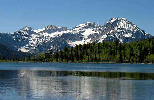
![Timpanogos from Silver Flat]() Timpanogos from Silver Flat Reservoir
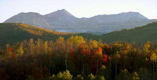
Timpanogos from Silver Flat Reservoir![Timpanogos Fall Colors]() Alpine Loop fall colors
Alpine Loop fall colors


Comments
Post a Comment