
-
 12587 Hits
-
 86.37% Score
-
 22 Votes
|
|
Canyon |
|---|---|
|
|
45.61477°N / 13.88420°E |
|
|
Hiking, Sport Climbing, Bouldering, Scrambling |
|
|
Spring, Summer, Fall, Winter |
|
|
In Slovenian language č, š and ž are pronounced like ch, sh, and zh. Our valley is written: Glinščica, in Italian Val Rosandra.
Overview

Autumn scene
Near the Adriatic coast there is a famous land step where Istria peninsula is attached to the rest of the continent. In the NW-SE direction a long series of vertical limestone walls is rising, due to their sunny orientation very popular among climbers. These crags, cliffs and towers are not very high, but just enough to offer amusing climbs. The whole area is also very suitable for hiking and biking. Otherwise, Val Rosandra / Glinščica is also a protected natural reserve, with special fauna and flora, and also one of the most distinguished geosites of Friuli. Finally, the valley has also some distinguished historical and cultural attributes.
From the continental part, be it in Italy or in Slovenia, no river or creek is flowing down into the Adriatic. All sources come out below the land step, and then flow across Istria, or whatever short stretch to the Adriatic sea. But there is one exception - the creek of Glinščica is having its sources below Slavnik mountain, 1028 m, and is then flowing all the way down, until in the Bay of Trieste / Trst it inflows into Adriatic sea. The valley of Val Rosandra / Glinščica is thus the only valley cutting the above mentioned barrier and hosting also a nice creek. In its middle part, Val Rosandra / Glinščica is a true canyon, which gives it an additional attractiveness. Otherwise the valley is deeply cut into a typical karst plateau.
In the Italian area of Val Rosandra / Glinščica the Slovenian minority is living, so on this page names are written in both languages. Also the valley itself stretches over the border between Italy and Slovenia.
A Short Geographical Overview

Like a spilled blood over limestone
Below, the valley of Val Rosandra / Glinščica starts in the village of Bagnoli della Rosandra / Boljunec. Then it first runs in the E-NE direction, but on the point where a sharp, rocky side ridge descends into the valley from Cima Comici, the valley turns into the SE direction. Just before the hamlet of Botazzo/Botač, the lower part finishes with a high and picturesque waterfall. In Botazzo / Botač, the valley branches. One side valley (Grižnik creek) ascends in the S direction towards Beka village (Slovenia), the main Glinščica creek valley ascends in the SE direction, continuing far towards the villages of Klanec and Kozina (Slovenia) and a short side valley (Krvavi potok creek) also ascends in the NW direction around Monte Stena towards the village of Draga / Saint'Elia. The highest point above the canyon part of the valley is Monte Stena, 442 m.
See also the page of related neighbouring area: Beka - Ocizla!
Show a bigger map
A Short Geologic Overview
The creation of this interesting valley is a result of its lithology, tectonic and erosion by water. In the area of Trieste it's the only example of a valley with flowing water stream. Among its most distinguished geological features are: a nice 30 m high waterfall, a gorge with cascades and nice ponds in limestone, remains of an old landslide, a big complex of underground karst caves, some specific rock types, karst sources like Antro di Bagnoli and Bukovec, a tectonic trench, aluvial deposites and rubble, the Bear's cave and more.
From the lookout points of Moccò and San Lorenzo we have nice views into the valley, on the crags above it, towers and landslides. The selective erosion is consequence of tectonic faults and lively geodinamic of the area. Even the small church of Sta. Maria stands on the edge of an old landslide. Along the road connecting Hrvati and Botač, we can see slates which are a sign of the border zone between limestone and eocene flysch.
In limestone hills around the valley there are many karst caves, rich with signs of the effects of ex flowing waters. In the caves fossils were found, but also remains of prehisoric and historic human presence. Especially Stena, 441 m, is abundant with caves. More than 50 of them extend underground totally more than 20 km, with some cave being more than 4 km long and almost 150 m deep. On the other side of the valley in the hill of Griža / Monte Carso, there are many caves which we can count to the nearby system of Beka-Ocizla. The entrance into Bear Cave is forbidden, due to its rich skeleton remains of cave bears and their preys, traces of leopard visits and also traces of dwellings of Neandertal man. Rich is also the cave decoration.
Items Of Interest
A precious water source
As the only water source in the vicinity of Trieste/Trst, the creek was exploited already by the Ancient Romans. Near the valley mouth the remains of an Ancient Roman aqueduct are well seen. Old water beds, a few arches, just enough to boost imagination. I don't know to what degree the source is exploited today, but in the valley no water capturing can be seen.
Another story are the water sources in Bagnoli della Rosandra, Boljunec village and its close surroundings. It's a few of them. And even if they are in some cases only a few tenths of meters apart, their origins are very different, which proves how unusual are the karstic underground water courses. The Antro di Bagnoli source brings water which sinks underground some good 3 km towards the SE, on the other side of Mali Kras hill, in the caves near Beka and Ocizla villages. The fountain on the village square however brings the water from Rosandra / Glinščica creek, which separates from the main stream just before it exits the valley. The stream of Bukovec is on the northern slopes of Mali Kras hill.
And last to mention are several water mills which had been on the Rosandra creek since medieval times. Interesting enough, they were not designed to grind wheat, but spices instead, arriving by ships from foreign countries. From some 16 such mills only a few ruins can be seen now.
A natural reserve
The whole area of Val Rosandra / Glinščica is today a protected natural area - a part of the natural parc, extending also on the neighbouring hills. Here is the link to basic information.
A great hiking area
Being just on the backyard of Trieste/Trst, a town of 200.000 people, Val Rosandra / Glinščica is an ideal place for people to get in nature. There is a good path through the valley - to Botazzo/Botač, along all the edges of the valley, also in the upper part, where a few sources inflow the main creek, and many paths, marked and unmarked, are also ascending from the valley out on the neighbouring plateaus. There are too many paths to name them all. It's perhaps interesting to mention that some of the tours can also be done with horses.
 In the canyon In the canyon |
 Canyon scenery Canyon scenery |
 Want to ride? Want to ride? |
A great climbing area

The list of named and described climbs is long and consists of some 400 titles! Most of the routes are short, from only 10 meters to some 80 meters. And even if most of them are not very hard, also some harder ones can be found. The range of routes difficulties varies from UIAA 3 to 8b. In the alpine history, the climbing area of Val Rosandra / Glinščica is mostly known by the name of the famous Emilo Comici. This great climber of the 20th century did a lot of hard climbs in Alps, but was exercising in his home valley of Val Rosandra / Glinščica. Still today a side ridge and a rocky peak in it carries his name - Cima Comici. So in a nice day on almost every rock, every tower and every crag people are hanging, giving a visitor an expression, that in Trieste/Trst just everyone does some climbing now and then. Here is the link to the list of most climbed routes in Italian (thank you, Fabrizio!).
 Climbers paradise Climbers paradise |
 Cima Comici Cima Comici |
 The slabs The slabs |
Our member Gabriele indicates the following two pages (in Italian) with routes descriptions:
Spigolo Verde (Cima Comici), 4 pitches, 3c: http://www.arrampicata.info/relazioni-vie-roccia/spigolo-verde-val-rosandra.asp
La Grande, 5 pitches, 5c: http://www.arrampicata.info/relazioni-vie-roccia/la-grande-val-rosandra.asp
Three ferratas. In the upper part of the valley, just south of San Lorenzo, where you can find short steep walls, members of CAI Trieste made three quite demanding ferratas (C/D on the Austrian scale). They are used mostly for exercising purposes and to gain experience on such routes. Looking up these are:
- Rose d'Inverno (Winter Roses), in the left wall,
- Naso (Nose), a short ferrata in the left wall,
- Via Bruno Biondi, crossing the entire right wall.
A nice creek, gorges and a waterfall

In the gorge

The upper part of the creek, till the settlement of Botazzo/Botač, is unknown to me. There still seem to be some rocky structures and perhaps the creek also there offers some picturesque scenery. But the part below Botazzo/Botač is definitely very nice and picturesque area. Soon below the settlement, there is a landmark of Val Rosandra / Glinščica. Some 40 meters high waterfall does not have allways much water, but is usually worth visiting. In times of heavy rainfall the waterfall is one of the most beautiful natural phaenomena in the vicinity of Trieste/Trst.
Just below the waterfall, the creek enters wonderful gorges. The abysses above the water are not very high itself, even if the rocky slopes there do form a real canyon, but the river bed is so nicely cut in the limestone bed. Calm ponds and winding creek flows are intermitting, if you come around in spring (let's say in April) or in autumn, also the surrounding nature is very picturesque.
Instead of hiking up the valley by the broad main path it is highly recommended to take the scramble by the river bed. As early as possible start scrambling, if the water is high also wading in some parts, until you reach the waterfall. There you exit on the left (orographically) side of the creek, where the main path goes. Otherwise tiny paths are going mostly on the other, right part of the creek.
 The creek The creek |
 The waterfall The waterfall |
 Wading Wading |
Panoramas
The edges of the surrounding plateaus are reaching altitudes some more than 400 meters. From them, you have very nice views, especially on the town of Trieste/Trst and its surroundings. We took two times an opportunity to be there in the time of the famous "Barcolana" race, where some 4000 sails vessels are racing on the sea, just outside Trieste/Trst. You can admire an endless number of white spots on the sea mirror, as if by some wonder snow would cover the bay.
 Socerb panorama Socerb panorama |
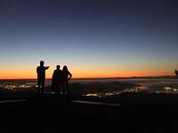 A. Vega - Socerb panorama A. Vega - Socerb panorama |
Biking tours
While the path through the valley is reserved for hikers, bikers are using the course of the ex railway. It ascended from Trieste/Trst, over the slopes of Val Rosandra / Glinščica reached the point above Botazzo/Botač, and continued on the todays Slovenian territory, coming out at Kozina. That is a nice challenge for mountain bikers, who can then return by ordinary roads or by train. By far the best tour is from Kozina down by the ex railway, through Val Rosandra and in Trieste. Then by tne boat to Muggia / Milje and by bike further to Koper. From there by train back. Over the neighbouring plateaus also many mountain bike routes lead.
 Below the biking track Below the biking track |
Cultural Heritage
The area was inhabited already in prehistoric times, what proves the remains of two bigger castellums: on Monte San Michele and on Monte Carso / Griža. The remains of Ancient Roman aqueduct were already mentioned. The second nice landmark is the cute church of Santa Maria. As in previous centuries through the valley a frequented trade route went inland (important due to Trieste salt works), above the path people built even before the 13th century a modest church. A bit remote, but nicely on the plateau edge above Trieste/Trst, stands the castle of Socerb. Today it is a restaurant, offering you a most beautiful panorama over the Bay of Trieste/Trst. Another medieval castle was Vikumberg, just below Žerjalski vrh (hill). And finally, also the hamlet of Botazzo / Botač with its popular inn is typical for this karst region.
 Socerb castle Socerb castle |
 Sta. Maria church Sta. Maria church |
Bruti della Val Rosandra
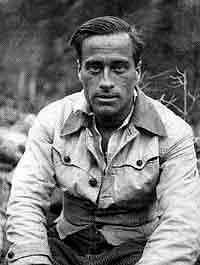
As in many other places in Alps also in Trieste a group of young enthusiasts formed a climbing group which became famous. It was in 1942 and they called themselves "I Bruti della Val Rosandra" (The Brutals of Val Rosandra). Their home climbing area was Val Rosandra, but they were very active across Alps generally. Many names of that group are still well known in the alpine world: Dalla Porta Xidias, Benedetti, Prato, Fabjan, Opiglia, Stefanelli and the most famous of all, Emilio Comici. A true multi-ethnical group, great friends despite of, and against fascism which was raging at that time. Let me write here just one idea, attributed to Comici. What's the ideal climbing line on a mountain? It's the line that a water drop would make, sliding down from the mountain top.
Getting There

The broader area of Karst Edge
Trieste/Trst can be reached by plane, train or by a highway from Venezia or Udine. From the Slovenian side you reach the coastal area by the highway from Ljubljana and then use one of many local roads to the town. The trailhead of most of usual tours in Val Rosandra / Glinščica will be the village Bagnoli della Rosandra / Boljunec, lying just in the valley mouth. But the valley can also be reached from the villages on neighbouring plateaus. See more in the Hikes Proposals section below.
A Few Hike and Bike&Hike Proposals
Below I just described three tours, which I did (some more than one time). Of course many other tours are possible.

In the canyon
1. From Bagnoli della Rosandra / Boljunec to Botazzo/Botač
Enter the valley by the main path, have a look on the remains of Ancient Romans' aqueduct and continue to the point, where the ridge from Cima Comici comes down in the valley. There go to the creek and continue just along the water bed. Switching the sides scramble till the big waterfall. There exit on the SW side and continue by the main path to Botazzo/Botač. Return by the main path, but on the return visit also the church of Santa Maria and Cima Comici. Some 5 hours.
2. From Beka
Beka village (Slovenia) can be reached by a narrow asphalt road from Kozina, via Ocizla village. Park there. Continue by the macadam road towards Socerb (SW direction) into the near valley. There you'll see yellow marks, leading you left down from the cart-road, towards the caves of Ocizla. You might wish to visit also these (1 hour for a round tour). Otherwise on the same spot where marks leave the cart-road, deter right (NW) and follow tiny paths over the karst plateau towards the edge of Val Rosandra / Glinščica. These are ex smugglers paths, where people from eastern countries were smuggled into the Western Europe. When you cross the state border you'll find the first well marked paths and inscriptions. Choose the left path, going on the belvedere above Val Rosandra / Glinščica. From there you have an excellent view on Trieste and Bagnoli della Rosandra / Boljunec just below you. Then descend into Val Rosandra / Glinščica. Continue by the creek bed (as described above under #1) into Botazzo/Botač. From there you can return in Beka by a good marked path, partially a cart-road. Some 6 hours.
3. Over Monte Stena
Leave your bikes in San Lorenzo, north of Val Rosandra / Glinščica. Go on the valley edge and enjoy the view from one of belvederes. Then drive with your car down into Bagnoli della Rosandra / Boljunec. From there start hiking into the valley and go to Botazzo/Botač, as described above under #1. From the hamlet ascend the summit of Monte Stena and continue over its plateau to San Lorenzo village. Then just descend with bikes down to your car. The starting point for this tour can be also any other village on the northern side of the valley. Some 4 hours.
When To Visit?
Val Rosandra / Glinščica can be visited any time of the year, but certainly the best months are in spring and autumn. Then the creek has enough water and also climbers might enjoy sunny climbs, while the high mountains are perhaps already/still covered with snow.