
|
|
Mountain/Rock |
|---|---|
|
|
36.28819°N / 51.35444°E |
|
|
Mountaineering |
|
|
Summer |
|
|
13222 ft / 4030 m |
|
|
Overview
Click for Introduction to Central Alborz Mountains.Click for Detailed Map of Central Alborz Mountains
Name Alert: The names Veravasht & Dehla have been used interchangeably for this mountain. Technically, Veravasht is the 4030 m summit while Dehla is a 3943 m high point to the southeast of the summit (see photo here).
Overview of Noor Mountains, a sub-range of Central Alborz Mountains:
 Base of Veravasht
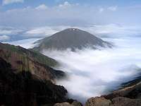
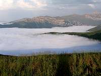
Stretching from the Haraz Valley to the east, to the Chalus Valley to the west, the peaks of the Noor Mountains create a 100 Kilometer long ridgeline that rises to the north of the Noor Valley in the northern portion of the Central Alborz Mountains of northern Iran. The distance between the Noor Mountains and the Caspian Sea is 35-45 Kilometers. The Noor Peaks mark the boundary between the forested mountains to the north and the bare ones to the south. As you move south from the Caspian Coast, you quickly run into heavily forested mountains that have elevations in the 1000 and 2000 meter range. The forests generally continue up to around 2300 m. The Noor Ridgeline contains the first peaks whose elevations exceed 3000 m. The peaks in the eastern ¾ of the ridgeline are between 3200-3587 m high. In the western ¼ the elevations go above 3600 m and culminate in the 4030 m summit of the Veravasht Peak. The Noor Mountains create a formidable barrier to the moisture laden Caspian air. The deep valleys to the north of these peaks lead to the Caspian Sea and are often fog filled.
Veravasht Peak (4030 m)
 South View, (L) Veravasht & (R) Basham Sardi
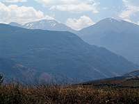 From NW
 From summit
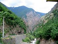
Veravasht is the highest peak of the Noor Mountains. It is a giant mountain that towers above the southeastern corner of the Chalus River Gorge. The western slopes of Veravasht drop 3000 m (10 000 ft) to the banks of the Chalus River where the Karaj-Chalus Rd, a major artery connecting Tehran to the Caspian Coast, runs. To the northwest, Veravasht connects to the 3434 m Shah Peel Kooh and to the southeast, it is connected to the 3935 m Basham Sardi Peak (via a smaller peak known as Usher, see below). The northern slopes of Veravasht are very steep and rocky. Its southern slopes go down to a branch of the Chalus River.
 North Slopes
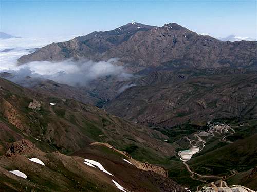
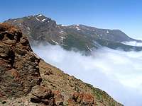
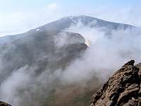
The distance between the summit of Veravasht and the Caspian Sea is only 42 Km (26 miles). Caspian forests cover the eastern, northern and western slopes of Mt. Veravasht up to an elevation of 2300 m. These slopes are often covered by clouds. From the summit of Veravasht you can have magnificent views of the peaks of the Takhte Soleyman Massif (highest point 4850 m) to the west and the Kholeno massif (highest point 4390 m) to the southeast. Clouds, however, can obstruct the views (as they did on the day that we climbed it).
 Veravasht & Basham Sardi
The usual starting point for climbing Mt. Veravasht is the village of Vali Abad (2050 m) or its nearby Harijan Village ( both to the southwest of Veravasht). These two villages can be accessed via short drives off of the Karaj-Chalus Rd north of the Kandovan Tunnel. As alternatives to the usual climbing routes, I will offer here an ascend route via the summit of Basham Sardi Peak and a descend route via the long northeastern ridgeline of Mt. Veravasht (see below and see “Route”).
 Summit
The northeastern ridgeline of Mt. Veravasht and Jirchal Peak (3750 m)
To the northeast of it, Mt. Veravasht has a long and serpentine ridgeline that drops down to the bottom of a valley at around 1100 m of elevation. The village of Keykoo sits at an elevation of 1850 m on the slopes of this ridgeline. My guide and I had not heard anything about any routes on this ridgeline, nevertheless, we decided to descend it to Keykoo. Below you will see pictures of this ridgetop route. Be ware that parts of this route are covered by nasty slippery scree slopes that can be quite dangerous. We were in the area in cloudy weather with limited visibility. Better options that we were not aware of might have existed. The distance from the summit of Veravasht to the Keykoo Village was 16.5 Km per my GPS.
 Jirchal
a) NE ridgeline above 3700 m
Above 3700 m, the ridgetop is broad and gentle allowing you to quickly descend to a high point known as Jirchal Peak (roughly 3750 m).
 Shah Peel Kooh Shah Peel Kooh |  Shamzar/Owlaj Shamzar/Owlaj |  Veravasht Veravasht |  Shah Peel Kooh Shah Peel Kooh |
b) NE ridgeline 3000-3700 m
Between 3000-3700 m the ridgeline becomes steep and rocky. You will have to find your way down nasty gullies that are covered by loose rock
 Scree Scree | 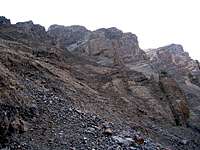 Scree Scree |  Scree Scree |
 Red Rock Red Rock | 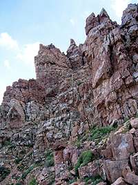 Red Rock Red Rock | 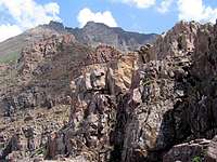 Rocky Ridge Rocky Ridge |
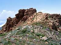
c) NE ridgeline 2400-3000 m
Here the ridgetop becomes broad and gentle again. You will find yourself surrounded by lush meadows.
 NE Ridgeline NE Ridgeline |  Poppies Poppies |  Poppies Poppies |
 Owlaj Owlaj |  |  |  Shamzar Shamzar |
d) NE ridgeline below 2400 m
While many of the nearby slopes in this zone are covered by dense forests, the slopes above the Keykoo Village remain grassy allowing for easy descend.
 Firooz Abad Firooz Abad |  | 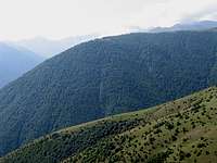 | 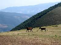 Mad Donkey Mad Donkey |
 Keykoo Village Keykoo Village |  Rd to Keykoo Rd to Keykoo |
Usher Peak (3858 m)
 Usher
UsherOn the crest of the ridgeline that connects Veravasht Peak to the Basham Sardi Peak, you will find a smaller peak known as Usher (pronounced Aa-sher). This peak has gentle slopes and rises 120 vertical meters above the saddle to its southeast and 80 m above the saddle to its northwest. A descending ridgeline on the southwest of the summit gives rise to a series of rocky high points known as Lachal Peaks (3562 m).
 Lachal Lachal | 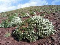 Below Summit Below Summit |  NE from Usher NE from Usher |  Chalus Valley from Usher Chalus Valley from Usher |