
|
|
Mountain/Rock |
|---|---|
|
|
45.61584°N / 24.62596°E |
|
|
Sibiu |
|
|
Hiking |
|
|
Spring, Summer, Fall, Winter |
|
|
7713 ft / 2351 m |
|
|
Overview
Located just north of the main ridge of the Făgăraş chain, this peak can be considered a lesser sibling to its southern neighbor, Vf. Vânătoarea lui Buteanu. Netedu is reportedly the 8th highest peak in Sibiu County and the 89th-highest in Romania. Thus it is a significant peak, though not particularly impressive within its neighborhood. It is best known due to its easy access: it overlooks the Transfăgăraşan highway near Bâlea Lac, and a trail from the lake will get you to the summit in under an hour.
Summitpost could use some more coverage of the Fagaras, and I happen to have hiked over Netedu, so while the peak is not exactly a classic, it's one for which I can write a page.
A narrow ridge joins Netedu to Vf. Vânătoarea lui Buteanu. The same ridge, known as Muchia Buteanu in its upper parts, also extends north from Netedu, over a series of lower peaks, all the way to the floodplain of the river Olt. I've hiked over those lower peaks too, so I'll briefly describe them on this page.
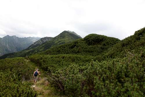
In South-to-North order, the peaks on the ridge Muchia Buteanu are: ![Vf. Netedu]()
Vf. Netedu from near Balea Lac
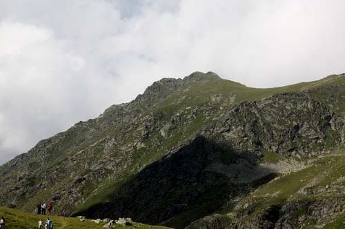
Vf. Netedu from near Balea Lac
| Peak | Altitude | Name Translation |
| Vf. Vânătoarea lui Buteanu | 2,507m | (see below) |
| Turnul Plecat | 2,410m | Departed Tower |
| Vf. Netedu | 2,351m | Smooth/Grassy Peak |
| Vf. Găvanului | 2,120m | Cauldron Peak |
| Vf. Buteanu | 2,056m | (probably an eponym) |
| Vf. La Lacut | 1,916m | Peak by the Tarn |
| Vf. cu Jnepeni | 1,834m | Peak With Dwarf-Pines |
| Vf. La Piatra Răsunătoare | 1,779m | Peak by the Echoing Rock |
"Vânătoarea" means "hunter", but apparently that name stems from a 19th-century mistake. The original "Vânătarea" may have something to do with rockiness, so something like "Buteanu's Rocky Peak" is a possible meaning.
"Buteanu" in turn seems to have been named for a person in the 18th century. "Butean" is a family name still in use today, possibly originally meaning a person from the village of Butea in Iaşi county.
Getting There
Netedu is located in the heart of the Făgăraş mountains, about halfway between Vf. Negoiu and Vf. Moldovianu. From Sibiu, the county capital, head east on the E68 highway (a.k.a. National Road #1). For the closest approach, turn south on the Transfăgăraşan highway (highway 7C) and park at Bâlea Lac, just before the highway tunnels through the highest part of the range.The Transfăgăraşan highway is a minor miracle of engineering (and also a monument to conscript labor, with an unknown death toll during construction). Some passengers may find themselves un-nerved by narrow hairpin turns over airy drops. On descent, most drivers would be well-advised to pause at least once to let their brakes cool. This is all normal stuff in the high mountains, but bears mentioning in the context of this relatively modest mountain range.
For a much longer approach that takes in the whole Muchia Buteanu ridge from the very bottom, you could start near Păstrăvăria Albota, a trout farm and resort located south of the village of Arpaşu de Sus (which is south of Arpaşu de Jos, which is on the E68 highway about 4.5km east of the Transfăgăraşan highway.)
As of summer 2016, the road south from Arpaşu de Sus was paved up to Albota resort; the road east from the Transfăgăraşan highway {starting south of Cârțișoara} to Albota was not paved but was easy to travel.
Maps
1. Interactive / DownloadableHere are some decent online maps of the central Fagaras, found by authors of other Summitpost pages:
topo from Karpaty Travel .PL
Welcome to Romania .RO
Muntii Nostri (click the grey "trails" tab in the center) (available for download too)
OpenMaps (online maps and downloadable GPS tracks - does not show all trails in this area)
2. Paper
I relied on the Muntii Nostri map of Fagaras, which is actually a set of two maps, one at 1:75,000 scale and the other at 1:35,000. The cartography is top-notch, with everything clearly marked, and trail descriptions on the back (in Romanian and English). Unfortunately the maps are large, awkwardly folded, very fragile, and not waterproof.
Since it was a pain to unfold the Muntii Nostri map, during the hike I tried using an A4-sized "trail map" sponsored by Albota resort, which proved not to be particularly reliable. We had a third map as well:
3. Other
My hiking partner used his mobile phone to snap a picture of the trail map posted on a big sign at the edge of Arpasu Nature Reserve, and this worked surprisingly well. The sign is here: N 45.69471 E 24.60963
(it's southeast of the even bigger sign with the wildlife photos, by a picnic table, facing south)
Trail numbers used on this page are those used by the Muntii Nostri map.
Trailheads (North)
Balea Lac
1. Bâlea Lac
At the highest point of the Transfăgăraşan highway (at the north end of the tunnel). See directions in "Getting There" section.
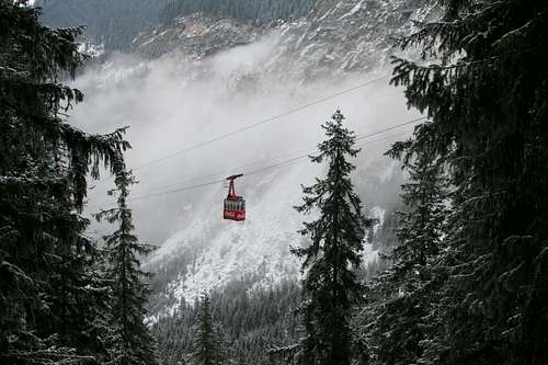
Note that in winter the Transfăgăraşan highway will be closed above the Bâlea Cascade trailhead, which is a few kilometers below the lake. You can still reach Bâlea Lac by taking the cable car (costing 30 lei each way) from the Cascade exit (the gondola serves the Ice Hotel built on the lake every winter).
2. Bâlea Cascada
The last exit from the Transfăgăraşan highway below Bâlea Lac. From here a cable car can take you to the lake. The short hike from here (with a bit of in-the-woods scrambling toward the end) to visit the bottom of the cascade (#31 trail, red dot) is well worth the effort.
If the cable car feels like cheating, you can follow an unblazed trail almost due east from the cable car parking lot. This takes you to a higher section of the highway at about about 1,500 meters of elevation, a bit south of the trailhead for the #39 trail (blue stripe).
![Lake Bâlea cable car]()
Lake Balea cable car
You can also follow the #30 trail (blue triangle) from the Cascada parking lot, crossing the stream and eventually passing by the waterfall on the west side. This trail continues south along the slopes west of the Transfagarasan highway and eventually reaches Bâlea Lac.
3. Highway-side trailheads (not well marked, limited parking)
A. The #39 (blue stripe) trail leaves the Transfăgăraşan highway at about 1,500m elevation, almost exactly above the parking lot for Bâlea Cascada (lat/long: 45.6381, 24.61285).
B. The #36 (yellow cirle) trail comes alongside the highway at the first (and northernmost) hairpin above the lower gondola station (about 1,450m elevation) (lat/long: 45.65396, 24.60973). This trail eventually meets the #39 trail.
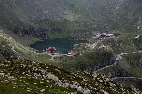
4. Near Albota Resort
Albota is visible down there
From the entrance to Albota resort, continue south about 2km until you reach a gated fork to your right. This is the trailhead; you should see an obvious yellow-dot blaze. Park along the road.
B. There is another trail that, starting from roads near Albota resort, follows the valley east of the Muchia Buteanu ridge (following the brook called Arpăşelul) and eventually climbs to a pass (Saua Netedu) just south of the summit of Netedu. That would make a (long) loop possible from Albota.
I have not hiked this trail nor seen its southern trailhead, but I have seen its upper end, so I'm confident it exists (but I'm not so sure about the shelter(s) marked on some maps). Proceed south from Albota as if making for the #36 trail, but continue south instead of stopping at the gated fork. At the end of the road (my maps disagree on how much of this trail counts as a road, anywhere from 1.5km to 3.5km past the fork) you should see a trail continuing along the stream. It may or may not be blazed with red dots.
Trailheads (Other)
The east-west trail along the main Fagaras ridge (#1, red stripe) passes near no roads other than the Transfăgăraşan, but has many huts and camping spots near it. See the sections on Huts and Camping below.The approaches from the south are also very long, unless you park along the Transfăgăraşan highway. In particular, there's a teeny bit of parking at the southern end of the tunnel (where there's also a refuge, and a trail leading to the main ridge), and nearby at the "cabin" called Salvamont Cota (where there's a trail leading to the main ridge via Capra Lake).
Note that the ridge (Muchia Buteanu) connecting Netedu to the main line of the Fagaras, via Vanatoarea lui Buteanu, is a technical climb in the section just north of Vanatoarea lui Buteanu. For most people, then, to reach Netedu from any direction other than North requires a slight detour, either to Balea Lac or to the small valley just east of Balea Lac (Caldarea Vaiuga via the pass Saua Vaiuga).
Routes
The shortest way (about 1.7 km with 300m gain one way): Park at Bâlea Lac. From the northeast corner of the lake, follow the blue-stripe trail (#39) northeasterly. After a short traverse, you'll find yourself below a small valley, where the #38 trail (blue dot) branches southeast along the stream towards Văiuga Pass (Saua Văiuga). Stay on the blue-stripe trail for a gentle northeasterly climb to the crest of the ridge (at a saddle called Saua Netedu). Then follow the ridge north to the summit of Netedu. Over all the northern peaks (about 7.5 km with at least 1600m gain one way): Once you find the trailhead south of Albota resort (see Trailheads section above), follow yellow blazes on a broad trail almost due south up a wooded ridge. After about 3.4 km you'll come alongside a loop of the Transfăgăraşan highway (there's a good spring here) and emerge onto a grassy road through a meadow with views east and north. Continue south (watch for the spot where the trail leaves the grassy road and re-enters the woods). About 1.5km further south you'll reach Vf. la Piatra Rasunatoare, where we nearly lost the trail. If you find yourself on questionable ground, backtrack and look for blazes to the right (west) of the crest. From here the trail makes a descending traverse toward the northern trailhead for the blue-stripe (#39) trail.
Once on the #39 trail, make a rising traverse on a sometimes-overgrown trail until you reach the crest amid scrub-pines. After Vf. la Lacut, the trail drops down to a couple of small tarns, then makes a short but steep climb back up to the crest. From here it's easy uphills along a broad grassy ridge, over a couple of minor peaks (Vf. Buteanu, Vf. Gavanului) to the top of Vf. Netedu.
Once on the #39 trail, make a rising traverse on a sometimes-overgrown trail until you reach the crest amid scrub-pines. After Vf. la Lacut, the trail drops down to a couple of small tarns, then makes a short but steep climb back up to the crest. From here it's easy uphills along a broad grassy ridge, over a couple of minor peaks (Vf. Buteanu, Vf. Gavanului) to the top of Vf. Netedu.
Treeline: heading south from Vf. cu Jnepeni
Note: a bold hiker can continue south from Netedu along the trail-less ridge of Muchia Buteanu, but you won't get far before you hit technical terrain. To reach Vf. Vânătoarea lui Buteanu from Netedu, follow the trail northeast until you reach a stream, then follow the #38 trail (blue dot) along the stream and then up some loose talus to Văiuga Pass (Saua Văiuga), a stone's throw from the summit of Vânătoarea lui Buteanu.
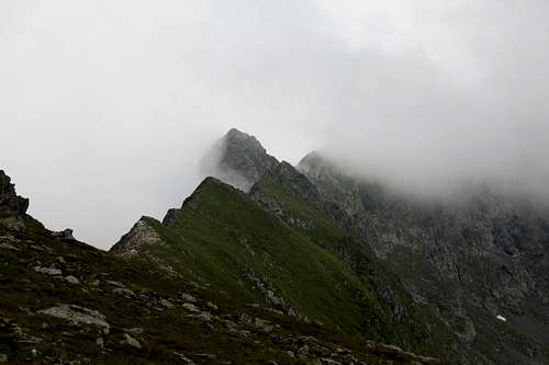
upper ridge
Red Tape
Vf. Netedu lies on the border between two nature reserves:Reservatia Naturala Valea Balii covers the valley from Cascada Balea up past Balea Lac, with its borders at the ridge crests.
Reservatia Naturala Golul Alpin al Muntilor Fagaras covers an above-treeline area north of the main Fagaras ridge, bordered by Muchia Buteanu on the west and extending past Muchia Podragu on the east (stopping before the shores of Lacul Podragu).
The woods to the north lie within Reservatia Naturala Arpasel.
Other parks and reserves cover some other sections of the Fagaras - see the Muntii Nostri map.
I cannot find a list of rules governing these reserves. There is no entry fee and I never saw anyone resembling a ranger. No hunting, it seems safe to say, and no collecting wildflowers.
When to Climb
Can be done year-round. In summer, be prepared for crowds. On Sunday afternoons, expect traffic on the Transfăgăraşan highway to come to a complete halt for several kilometers.
In winter, much of the Transfăgăraşan highway will be closed. However, the gondola will run from Bâlea cascade to the lake, where in winter there is an Ice Hotel.
Be warned that there are virtually no cairns. Blazes consist of colored symbols painted on the natural rock, which will vanish under snow.
Be warned that there are virtually no cairns. Blazes consist of colored symbols painted on the natural rock, which will vanish under snow.
Beware of avalanches! Here is a blog that often updates snow conditions in the Fagaras (in Romanian):
Weather
Romania has a mild, continental climate, but the Fagaras range is tall enough to affect the weather. This includes plenty of snow in winter.
Camping
The general rule in Romania is that you can camp anywhere. The immediate vicinity of Balea Lac was empty of tents (except for a small designated area where a sign mentioned a fee), so I assume there's a special rule there. Also some spots beside the Transfagarasan highway were marked "private property - no camping".In the neighborhood of Netedu, the most popular campsite by far is on the shore of Lacul Capra, just south of the main Fagaras ridge.
Huts and Refuges
A refugiu (refuge) is usually a single-story structure with a few bunk beds, a stove, and perhaps a few tables.
A cabana ("hut") is usually a four-story hotel built to resemble an overgrown chalet.
There are two cabanas and a refuge at Balea Lac, a refugiu at the south end of the tunnel, a cabana (Salvamont Cota) just south of there along the highway, a cabana near Balea Cascada, and several hotels, hostels, etc. at various further points on the Transfagarasan highway to both north and south.
The next shelter to the east along the main ridge is Refugiul Fereastra Zmeilor.
To the west, the next shelter is Refugiul Caltun.
For many useful details on these "huts" and refuges, see the Huts and Refuges section of Summitpost's excellent multi-author page on the Fagaras Mountains.
peterbud - Aug 24, 2016 5:15 am - Voted 10/10
Fine jobThanks for taking the time and effort to add this mountain to SP, it is very informative! I would only come up with a few notes: 1) 'Buteanu' is a family name - we don't know exactly whom it refers to, but it already appears on 18-19th century maps of the area. 'Vânătoarea' translates to 'Hunter', but as it's mention on its SP page as well, this name stems from a mis-spelling issue. However, that issue is quite old (can be traced way back to the 19th century), so it has gained strength over the original name. 2) 'Vf. Netedu' translates to 'Smooth/Plain peak' (name usually applied to peaks with grassy slopes, pops up in several other places as well) and 'Vf. Găvanului' translates to 'Cauldron peak'. 3) The Muntii Nostri Map can also be browsed online, just surf to http://muntii-nostri.ro/en/munte/muntii-fagaras-2/ and click the "trails" tab. It is also available for "smart mobile" devices for offline use. If one happens to have/use GPS device, they might want to know about www.openmaps.eu which offers open access topo map (with trail marks) for entire Central Europe. 4) Winter access can be dangerous, because the slopes are prone to avalanches: http://avalanse.blogspot.ro/2011_04_01_archive.html http://avalanse.blogspot.ro/2014/12/conditii-de-zapada-si-avalanse-13.html
nartreb - Aug 24, 2016 11:39 am - Hasn't voted
Re: Fine jobMany thanks, added this info to the main page.
SzaniUherkovich - Aug 29, 2016 2:26 am - Voted 10/10
Potential primary imageHi, I like your new page, it's a nice job with precise detials in many aspects! I just added a photo about the mountain. It shows the whole mass of the mountain. If you wish, you can use it as a primary image for the page. (Unfortunately its colors are not too bright since I took the photo early morning, but the contours of the mountain are seen well) Best regards, Szani