
-
 7162 Hits
-
 85.87% Score
-
 21 Votes
|
|
Mountain/Rock |
|---|---|
|
|
37.90228°N / 14.06091°E |
|
|
Hiking |
|
|
Spring, Summer, Fall, Winter |
|
|
5289 ft / 1612 m |
|
|
Overview
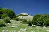
 Croce dei Monticelli's easy soth slopes Croce dei Monticelli's easy soth slopes |
Pizzo Carbonara, Sicily's second highest mountain, is a huge massif reaching almost 2000m. It consists of karst-like limestone formations with huge plateaus interspersed with deep valleys and funnel-like hollows, formed by the collapses of underneath cave structures. Out of this archaic landscape a multitude of summits rise, many of which bear their own names though they certainly are but minor hills when seen from the plateau. On the eastern side of the Carbonara Massif, however, you can find a set of several of these hillocks, which on the eastern flanks drop sharply into the valleys below. Most of these summits have been adorned with crosses, to be distinguished angainst the rough outline of the Carbonara massif behind, when seen from below.
Croce dei Monticelli is one of these summits, the only one which bears the cross in its name. As seen from the east it towers above the town of Castelbuono on the south-eastern end of the Carbonara Massif. Thanks to its location it commands very good views towards the Monti Nebrodi Range and towards Monte Etna itself. Croce dei Monticelli is typical for the mountains of the Carbonara Massif, as it has a rough limestone summit, very hard to scramble on top of because of the many loose rocks. On the slopes of its upper flanks beautiful mountain flowers grow in its cracks, mainly ashopdel, cyclamen and butterfly orchids.
Speking of the flora - the slopes above Castelbuono, of which Croce dei Monticelli is a part of are covered with some of the oldest forests on the island of Sicily. Huge oaks grow there while on top of the plateau you can find beautiful beeches. The most remarkable plant of the region you can find on the southern slopes of neighbouring Cozzo Luminario: giant holly trees, with diameters of up to 2m. All these forests are very dark - which makes them a welcome refuge from the extremely bright Sicilian sun.
So popular indeed, that the area can be called "crowded". Six of the seven people we met n our rambles accross Sicily crossed our paths here. To "blame" is Rifugio Crispi, an alpine sytle hut above Castelbuono, which can be reached by car from the town and which serves as both picnic area and as trailhead for the Carbonara Massif. Indeed the roundabout ascent to Pizzo Carbonara can be started here, a 5h hike along wide paths.
|


The summit views
  |
Not quite as perfect, as there was nuch haze, still these pictures should give an idea, what the views from Croce dei Monticelli look like. The Carbonara Massif, the northern coast of Sicily, the Monti Nebrodi Range and even Monte Etna can be seen on a clear day. Also the Eolian Islands can be visible, though on our summit day they where hidden in the mist.
|


Getting There
Sicily can be reached from all Italian and the major European airports by plane. There are two large international airports, one at Catania in the east and one at Palermo. Since Palermo is much closer to the mountain than Catania my itinerary starts here. Also, Palermo is the main ferry port in the area.From Palermo airport
- Take motorway A29 direction Palermo
- In Palermo the motorway turns into a four laned city highway which circles the city to its south
- The city highway turns into motorway A20 direction Messina
- Turn off at the exit Castelbuono and follow SS286 the town
- At the end of Castelbuono turn off to the right in direction of San Gulielmo (look for signs). The road will take you to Rifugio Crispi, but it is advisable to start already at Contrada Castagna. From there a 1km long nature trail leads to the Rifugio.
Red Tape
 Iris versicolor
 The forests beneath Croce dei Monticelli and the other eastern summits of the Carbonara Massif is protected. The old beeches, ilexes and oaks clearly needed this protection. Also there is a long nature trail through these forests which you should not leave. In all the area belongs to the Parco delle Madonie, which was established in 1989 and covers an area of approximately 40000ha. In the Sicilian parks you can climb and hike almost everywhere. Obstacles are the many barbed wire fences, which however can be crossed. They serve only for the pastures and to keep cattle sheep and horses from getting lost in the vast terrain.
Camping is not tolerated in the park, better look for accommodation in the nearby towns and villages (Polizzi Generosa). The northern coast of Sicily is close by and there you will be able to find all kinds of accommodation (see below).
Accommodation
 Paghiaru, a sheperd's hut on Piano Pomo
You can quite easily find hotel rooms and apartments everywhere on the coasts. All European travel companies offer accommodation so a visit to your nearest travel office will find you some. In the mountains themselves accommodation is much harder to come by. Since camping is not allowed (see red tape) you have to ask at the local inns. Moreover there are some farms which offer “agriturismo” though on Sicily this often means only food and no rooms.
Rifugio Crispi, which is operated by the CAI serves as trailhead for all excursions in the area. The following link shows some more information as well as telephone numbers:
Weather Conditions
Sicily is located very close to northern Africa (Marsala on the west coast is closer to Tunis than to any place on the Italian mainland), thus temperatures can get very high. March, April and early May are the best months if you plan to hike the mountains, the winter can be wet, the summer scorchingly hot. Here the nearest weatherunderground link for Palermo:Maps & Books
Maps
Unfortunately there are no current topographic maps of Sicily. The best are reported to be more than 50 years old and probably are the same as the basis for the digital maps of atlanteitaliano.it.
As a workaround you can use street maps for general orientation together with a good guidebook (see below). The most accurate maps are scaled 1:200000, sometimes detailing everything down to forest and dirt roads through the mountains. I settled for
- Sizilien
Shell Generalkarte
1:200000
Mairs Geographischer Verlag
ISBN: 3-8297-2080-7
Books
Since there are no good topographical maps of Sicily you should take care to get a good guidebook. The one I used is in general excellent. For Croce dei Monticelli the descriptions were accurate. Two of the described tours touch the summit.
The book is available in German and English.
- Sizilien / Sicily
M. Omidvar
Rother Verlag
ISBN:
3-7633-4266-4 (German)
3-7633-4813-1 (English)