Beginning Labor Day in the Dark
![Broad s Fork meadow]() Broad's Fork Meadow
Broad's Fork MeadowLike a kid before Christmas, I do not get much sleep before a big hiking day. This time was no different, and I was wide awake at 3AM changing the baby's diaper and bringing him to his mother for feeding and comfort. I did not have to get up until 4:15, but I decided to eat my breakfast sooner rather than later so that I would not have problems with digestion while on the trail.
My friend and hiking partner Justin picked me up and we drove to the Broad's Fork trailhead in Big Cottonwood Canyon. A few cars were already there, and while we were gearing up, another vehicle pulled in and parked. Within less than a minute, two male figures, obscured by the pre-dawn darkness, greeted us and walked past, disappearing on the upward-bound trail. At 5:15 we were on our way too, walking briskly up the narrow path through the trees. Not far from the trail's beginning, I saw attached to some trees a light-beam unit and it's corresponding reflector. I have seen two others like this near the beginning of other local trails in the past few weeks. I can only guess they are for gathering trail-use data or are put there by hunters to alert them of movement on the trail. Either way, I get the feeling I am being watched in the dark.
Soon we came upon our fellow hikers who passed us in the parking lot, two older gentlemen. We passed them and predicted we would see them further up the trail as we headed to the same destinantion: Twin Peaks above Broads Fork. Justin and I had been up this trail once before the past year, when we hiked the standard route to the saddle south of the Twins, and up to the top. That time we were able to stay on top only for a few minutes as we found ourselves in the middle of an increasingly windy snowstorm, which also necessitated a hasty descent without getting over to the West Twin. Today was going to be our redemption, a chance to do it right.
We arrived at the meadow in an hour and fifteen minutes, quick for our standards. The sun was coming up and we rested for a few minutes as we looked to the West toward our intended route: The Robinson Coloir & Variation. Soon we were on our way up and up, rising with the sun to greater elevations. A mountain goat appeared above and ahead of us, like a white apparition, standing casually on the boulders. It moved along ahead of us, staying in view for some time but never allowing us to come near. Aside from that pleasant distraction, the hike up the steep slope over coffin-sized and shaped boulders was my time to warm up for the rest of the day.
![Heading up Robinson Couloir]() Looking up the Robinson couloir
Looking up the Robinson couloirRobinson Ridge
![Sharp, unnamed peak above Deaf Smith Canyon]() These slabs can be seen from the Salt Lake Valley as small, pointed peaks
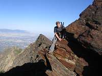
These slabs can be seen from the Salt Lake Valley as small, pointed peaksUpon reaching the ridge between Broad's Fork and Stairs Gulch, it felt good to finally see the terrain that I could only imagine before, like a father waiting to see the face of his newborn child. Up and south we continued, passing over massive, tilted slabs of quartzite, some of which were jutting sharply into the air over upper Deaf Smith Canyon and ending abruptly above a deadly drop hundreds of feet to the basin below.
From here it was up, over and around jumbles of jagged and broken rocks which formed the ridge leading up to the East Twin. To the East were sloped slabs which during the winter months release avalanches into the drainage below. Even without snow, a slip or fall could bring serious consequences: Just last June a teenage boy, just graduated from High School, fell to his death near here as he tried to get to his friend who had fallen.
At last, I reached the peak a short time before Justin. A check of my time confirmed that I beat my last time up by an hour and a half. Feeling good. Soon Justin appeared and we headed over to the West Twin, a first for both of us. From there, after a Hobbity 'second breakfast', we began the descent to the saddle between Sunrise and Twin Peaks. This was familiar territory. When we came to the crux section, we both decided to try it, since we avoided this way on our previous trip up. I followed Justin as he deftly swung around and worked his way over and down a narrow, stepped and tilted ledge. Within minutes he was through the crux and disappeared around a corner. At this point I was alone and wondering if I could really go the same way. I must admit, I began to panic a bit, and made a conscious effort to calm down. Would I slip and break my leg? Hit my head? "Justin," I crackled over the radio. "Can you come back and spot me?" A few minutes later he appeared and was helping me find some confidence. I learned later that he had gone quite a way down from where I was and had to come back up to lend me a hand. As we made our way down to the ridge/saddle, we met up with the two gentlemen we had surpassed on the trail up to the Broad's Fork meadow. One of my thoughts was that like them,I would like to be coming up here when I am in my fifties. We told them of our intended route and one of them quipped, "I'll hear about you in the news tonight." After a fare well, they headed up to the Twin Peaks.
![Robinson Ridge Scramble]() Climbing up Robinson ridge toward East Twin.
Climbing up Robinson ridge toward East Twin.Driving into the Sunrise
From the ridge-saddle between Twin Peaks and the peaks east along the traverse, Justin and I made our way up to the base of the buttress which forms the west side of the unnamed peak before Sunrise. We consulted a photo of the buttress which showed the best way up. Justin started first and I stood aside to avoid any loose rockfall he might send down. Soon it was my turn and I was anxious to get up. At this point, I had to convince myself that "This will be just like climbing a ladder." Up I went, steeply, on probably the most verticle I have ever been on a mountain scramble.
![Justin went first up Route A on west buttress]() Justin about halfway up the buttress.
Justin about halfway up the buttress.![Matt ascending the butress west of Sunrise]() Matt gets his comeuppance.
Matt gets his comeuppance.
Once we got onto safer rock, up we climbed to the top of the small, unnamed peak where we could see Sunrise, getting closer to the mounatain I have wanted to climb for some time. From the West, Sunrise Peak has a rounded wedge shape and an arcing ridgeline, reminding me of the tip of a gigantic thumb. It looks easier to climb than it really is and the time we spent on traversing these next few peaks set us behind a little from our planned schedule. On the way over to Sunrise, we met a few more fellows coming west from Dromedary. That had started at Lake Blanche. The older gentleman remarked that he had last climbed this peak 30 years ago. We said our greetings and continued on. I made a note of the dangerous terrain directly below and north of the peak. In July, a man who was hiking with his brother had slipped on a lingering patch of snow, apparently somewhere between Sunrise peak and its neighbor to the west. The man was unable to stop himself before he ran into the rocks and boulders below. Another accidental death in the Wasatch mountains. There are also several cliffs below the peak which should discourage anyone without the skill and equipment from trying to get down to the basin from here.
![Sunrise Peak from unnamed peak]() Sunrise Peak, looking east
Sunrise Peak, looking eastMt Dromedary & Down
![Heading towrd Dromedary from Sunrise]()
From the top of Sunrise Peak, the views remained terrific.We could see in every direction to places and peaks we had been so far this summer, and some we still planned to get to. After more snacks and phone calls to patient wives, we started down the east ridge of Sunrise. Steep, loose rock slowed us somewhat, and by this time, honsetly, I was thinking about home, and hot tubs, and my smiling 2 year-old. Again, Imagination can only hold a place for you until you are actually standing in the place you had imagined. We could now see Tanner's Gulch snaking down from between the two rocky peaks. After some careful moves, we stood on the small saddle between Sunrise & Dromedary. The man we met earlier told us that at the saddle we would have to turn left to bypass the 30 foot wall blocking the way. I think he meant turn right and descend a small distance in to Tanner's Gulch. A left turn could have taken us down a steep scree slope back into Broad's Fork basin with relative ease, but we were not going to miss out on completing the traverse. So it was down into Tanner's, then up toward our last peak of the day. The sun at this point indicated it was mid-day, and I was feeling the warmth of a cloudless, late-summer day. On the scramble up the West end of Dromedary, we passed yet another hiker, who said he had come from Alta across the Cottonwood Ridge. I looked down at Justin who was near but behind me and said, referring to the stranger, "Superhiker." At last, on top of Dromedary I felt a sense of accomplishment, but also a small sense of dread as we would have to soon find our way down to Lake Blanche through a series of cliffs that form a massive staircase in the west branch of Blanche fork. From a break in the ridge leading East from lower Dromedary, we scooted and slid steeply down scree into a waiting boulderfield. Boulderfields suck. From here is was mostly speculation on the best way down. I had read up on this area, but had forgotten most of the details. We were going by sight now, and very often in the mountains, looks are deceiving. We went left, or rather, North around the base of Dromedary in hopes of finding some nice gentle grassy slope down to the Lakes, which were still a few thousand feet below. Eventually we came to the top of a giant ridge, more like a peninsula that extended Northeast into the basin. Wed decided to downclimb, carefully too, because of the 200-foot drops on either side. Down, down, through cliff bands, more ridge scrambling, narrow gullies, and finally to some terrain where we couldn't fall from anything. We made our way over the rounded, polished, and striated quartzite slabs which characterize this area, to the nearest lake, Lake Florence. Relieved to be on firm ground, but also very aware of the 3-mile walk down in the hot afternoon sun. Sundial Peak, like an old friend, stood majestically above the lakes, its shape changing in our viewpoint with every step we took. Several times in my mind I repeated the thought that "The hike down is always longer than the hike up." 3 miles later we we at the car and happy for the experience, and happy to be headed home to wives and little ones who call us 'daddy.'
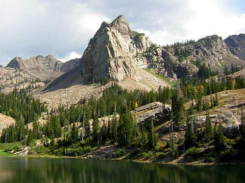
![Sundial Peak]() Sunrise Peak above Lake Blanche
Sunrise Peak above Lake Blanche


Comments
Post a Comment