
|
|
Mountain/Rock |
|---|---|
|
|
43.28150°N / 18.73728°E |
|
|
Spring, Summer, Fall, Winter |
|
|
7835 ft / 2388 m |
|
|
Overview
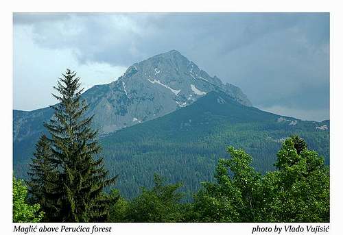
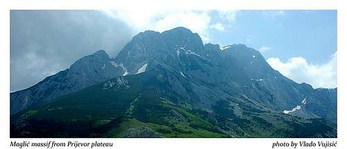
MAGLIĆ is the highest mountain of Republik of Srpska and Bosnia and Hercegovina, even its larger part of the massif is placed in Montenegro, said Branislav Cerović, famous mountain writer and one of the best knower of Montenegro's mountains. Maglić massif has two highest peaks, Veliki Maglić (Crnogorski Maglić (2388 m) and Mali Maglić (Bosanski Maglić, 2386 m). Crnogorski Maglić is the highest peak of MAGLIĆ, but official pride of the highest peak of Maglić belong to Bosanski Maglić, althought that peak is 2m lower than Crnogorski Maglić. Also, Bosanski Maglić is more remarkable peak than Crnogorski Maglić which is not so visited as first one.
Together with BIOČ , VOLUJAK and TRNOVAČKI DURMITOR, MAGLIĆ create a mountain complex in NW part of Montenegro, on the right coast Sutjeska river, which separates them from ZELENGORA peaks on the left coast of the same river. Together with Bioč and Volujak, Maglić massif create a mountain group which is lined by deep river canyions, by Sutjeska on western side, by Drina and Piva on eastern side, and by Vrbnica on southern side. Maglić is also surrounded by 4 vasty plateaus: Sniježnica, Vučevo, Ulobić and Prijevor. Until the elevation at 1600 m you can find a mixture of beech and arsenic forest, while above that elevation are placed grassy plateaus and rocky peaks.
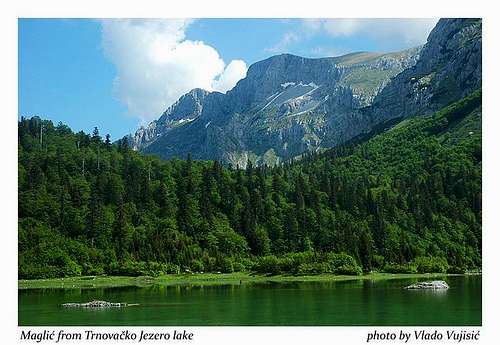
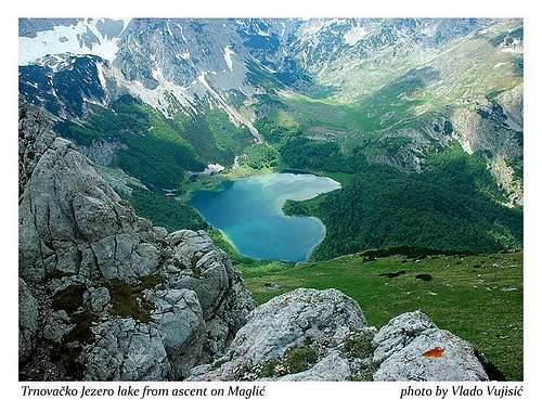
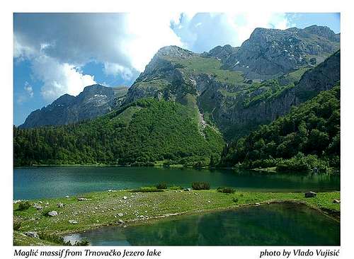
Maglić and its surroundings are very enriched by beautiful Trnovačko Jezero lake, which is most optimal place for camping before and after climbing of Maglić. The elevation of Trnovačko Jezero lake is 1517 m. It is 825 m long, 715 m wide, 9,2 m deep, with coastline long 2800 m.
You can approach Maglic from many direction. From Republika Srpska (Republik of Srpska) as a part of Bosna and Hercegovina you can approach from two direction, from Tjentište, and from the valley of Suha River. The summit of Maglić you can reach from Prijevor or Vučevo plateau. From Montenegro exist two dominant approches, first one from Stabanska Jezera lakes and second one from Mratinje village and than via Presjeka pass, which separate Maglić massif from Vrsta peak in Bioč range. The most remarkable and main peak of Maglić called Mali Maglić (Bosanski/Bosnian Maglić) dominate above Perućica virgin wood on one side, while on the other side its cliffs hanging above beautiful and unique Trnovačko Jezero lake and above Mratinjsko Jezero lake.
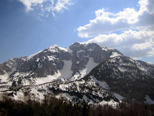
Summit View
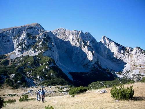
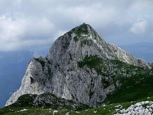 The rocky summit piramide of Maglic (2386 m)
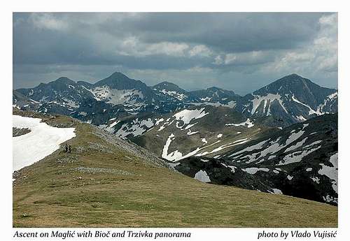
From the summit of Maglić you can enjoy in many beautifuly summit panoramas. Most beautiful view is to Trnovačko Jezero lake in the form of the heart and rocky massif of Trnovački Durmitor above it. Also, from Maglić summit you can admire the impressive beauty of the wild peaks of Bioč range. Above Suha Canyon Volujak massif is nicely visible, while on the other side Zelengora peaks are located. Finally, in the background you can recognize the highest and main peaks of DURMITOR range, specialy Bobotov Kuk, Bezimeni Vrh, Djevojka and Prutas which hanging above incredible beauty of Skrka Lakes Valley.

Routes Overview
ROUTE 1
Tnovačko Jezero lake (1513 m) - Šarena Lastva - Carev Do (2000 m) - Maglić summit (2386 m): 3.30h-4h
ROUTE 2
Mratinje (750 m) - Mratinjska Jezera lakes (1504 m) - Katun Presjeka (1826 m) - Carev Do (2000 m) - Maglić summit (2386 m): 4h
ROUTE 3
Mratinje (750 m) - Krč village (1000 m) - Katun Podstubica (1430 m) - Katun Klanac (1720 m) - Carev Do (2000 m) - Maglić summit (2386 m): 4.30h-5h
ROUTE 4
Mratinje (750 m) - Krč village (1000 m) - Katun Podstubica (1430 m) - Ledenice (1900 m) - Klekov Kom (2356 m) - Maglić summit (2386 m): 3.30h-4h
 North side of Maglic (2386 m)
Getting There
From Montenegro
Podgorica - Nikšic - Plužine - Stabna - Maglić
Podgorica - Nikšic - Plužine - Mratinje - Trnovacko Jezero - Maglić
From Serbia
Belgrade (Beograd) - Loznica - Mali Zvornik - Zvornik - Višegrad - Srbinje - Tjentište - Prijevor - than by walk to Trnovačko Jezero lake (shortest approach) - Maglić
Belgrade (Beograd) - Ljig - Cacak - Užice - Zlatibor - Nova Varoš - Prijepolje - Pljevlja - Ðurdjevica Tara - Žabljak - Virak - Sedlo - Trsa - Plužine - Stabna - Maglić (longer approach)
Belgrade (Beograd) - Ljig - Cacak - Užice - Zlatibor - Nova Varoš - Prijepolje - Pljevlja - Ðurdjevica Tara - Žabljak - Virak - Sedlo - Trsa - Mratinje - Trnovacko Jezero - Maglić (longer approach)
From Bosnia and Hercegovina
The M-20 highway from Foca/Srbinje to Gacko, which crosses through Tjentište, is the starting point for the approach to these peaks.
It can be reached by following the M-5 highway easy out of Sarajevo.
Camping
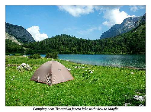

Maglic from Suha Jezerina Valley

Maglic above Trnovacko Jezero
Before and after climbing of the peaks of MAGLIĆ range, you can freely camping on many places around and below the mountain. First of all, you can camping near Trnovačko Jezero lake, than in the Stabna Valley near Veliko Stabansko Jezero lake and Malo Stabansko Jezero lake. Also, you can camping on Prijevor plateau or in Suha Jezerina valley. For sure, grassy plateau arround the Trnovačko Jezero lake is the best and optimal place for camping before and after climbing of Maglić peaks. From here starts the classical route to Maglić.
The elevation of Trnovačko Jezero lake is 1517 m. It is 825 m long, 715 m wide, 9,2 m deep, with coastline long 2800 m.
Meteo Info
 NW side of Maglic
The weather conditions before visiting MAGLIĆ range you can check on Vreme Yubc Net web site for Plužine town.
Red Tape
No extra fees.