
-
 23590 Hits
-
 80.49% Score
-
 12 Votes
|
|
Route |
|---|---|
|
|
42.81995°N / 109.26124°W |
|
|
Hiking, Mountaineering, Scrambling |
|
|
Summer |
|
|
Expedition |
|
|
Class 3 |
|
|
Overview
Foreword
Several times now, there has been a forum thread asking about Winds trip suggestions or I have received a personal request for such suggestions. Each time, I've recommended this route for its combination of hiking, peakbagging, and scenery, and I thought I'd create this route page for ease of reference in the future. This page itself only covers a hiking route, but it has links to four scramble-accessible summits along the way and is offered to appeal to those who want to mix long-distance hiking and summits without hauling the gear for technical climbing.
All That's Best About the Winds
The Wind River Range in Wyoming is no secret to backpackers and climbers, and it is one of the largest, wildest, and most scenic mountain wildernesses in the United States. Some routes into and destinations within the heart of the range-- Green River Lakes to Summit Lake, the Glacier Trail, Island Lake and Titcomb Basin, and the Cirque of the Towers-- are very popular and deservedly so. But with their popularity come the crowds, and the last two destinations can seem way too crowded for seekers of real wilderness.
There is another fine route deep into the range, and it is less popular than the others, probably because it does not access the highest peaks or the well-known climbing areas. This route is the Hailey Pass-Washakie Pass Loop, and it offers a bit of everything that is great about the Winds, plus the solitude of wilderness-- alpine lakes, rushing streams, vast meadows, windswept passes, lonely mountaintops, glaciers, and more. The glaciers here are few and are much smaller than those found to the north in the Gannett Peak area, but they are glaciers nonetheless, not the permanent snowfields often misnamed as glaciers. Rock climbers who want more wilderness than the Cirque offers can try Mount Hooker or any number of peaks, domes, and pinnacles along the way, though covering the climbing on them is beyond the scope of this page.
This is a route that is 33.5 miles in round-trip length without any side trips to summits listed below or the lakes described in the Route Description section. Together, the two alpine passes offer scrambling access to four peaks: Pyramid Peak, Mount Hooker, Mount Washakie, and Bernard Peak.
The Winds offer a lifetime's worth of backcountry explorations, and I tend not to repeat routes, but if I had to do any one Winds route again, it would be this one. One can easily spend a week out here with the trails, spurs, and summits and walk out with an unforgettable mountain wilderness experience.
Getting There
Big Sandy-- The drive to the TH may be the crux of this route because it is so long and parts are rough. Reaching the trailhead for the extremely popular Big Sandy area (it is the main TH for the famous Cirque of the Towers) requires a long drive, but there aren’t any access issues. Because there are several ways to get to Big Sandy, requiring so many details, I will just describe the one used most often, which is the approach from Pinedale.
Drive to Boulder, which is 11 miles south of Pinedale on U.S. 191, and then take WY 353 east. The pavement ends after 18 miles, and less than a mile after that, bear left at a junction (the right turn takes you back to 191). Almost 3 miles later, bear right at another junction (left goes to the Muddy Feedground). When you are a little more than 27 miles from Boulder, there will be another junction, where you turn left. A sign should be there indicating that right goes to Farson and left to Big Sandy.
The high desert and ranch country you have been passing through now open up to reveal views of the Wind River Range. 32 miles from Boulder, another signed junction will steer you left; right takes you to WY 28 and South Pass directly across from Oregon Buttes Road, a major access point to the Great Divide Basin.
Follow signs to the Big Sandy TH and campground. They are about 11 miles from the Big Sandy/South Pass junction mentioned above.
The last few miles to the TH are rough and rocky, but most passenger cars can make the trip. I have found the rest of the road system, every time I have driven it (2001, 2004, 2007) to be very easy going (when dry) and not at all rough and washboarded as some descriptions put it. The biggest danger, in fact, is going TOO fast on these roads and losing traction. Keep at 25-35 mph.
Bears Ears Trail-- From the Dickinson Park area near Fort Washakie, north of Lander, this trail adds distance and difficulty to the loop but also adds tremendous scenery and a measure of solitude. Unfortunately, the access road runs through the Wind River Indian Reservation, which has closed the road to public access without first buying a costly permit. For more information on this trail and the permits, please see the Mount Washakie page.
Route Description
This description takes you first to Hailey Pass and then to Washakie Pass.
The hiking route climbs about 2100’ to Hailey Pass in 13.1 miles via the Fremont Trail and the Hailey Pass Trail. Once you are a few miles from Big Sandy, crowds will almost certainly thin out dramatically, and the trail over Hailey Pass is rated as lightly trafficked. Campsites are plentiful, and there are some very scenic lakes between the junction with the Washakie Pass Trail and the climb to Hailey Pass. There are also very worthwhile spur trails to Shadow Lake and to Pyramid Lake.
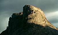
Hailey Pass provides hiking/scrambling access to Pyramid Peak and Mount Hooker.
From 11,200' Hailey Pass, hike 5.3 miles to the junction of the Bears Ears and Washakie Trails. Along the way, you will pass scenic Grave Lake and the easy-to-miss spur to awesome Baptiste Lake, which you should visit if time permits-- it's a true alpine gem. The spur is 1.3 miles from Hailey Pass, 2.3 miles from the bridged crossing of Grave Creek near the eastern end of Grave Lake.
 Grave Lake
There are some spectacular campsites around the Bears Ears/Washakie junction, and they have views like this one:

From its junction with the Bears Ears Trail, the Washakie Trail climbs to 11,611’ Washakie Pass on the Continental Divide in 3.5 miles. There may be steep snow to cross just below the pass. The pass is where you access climbing routes for Mount Washakie and Bernard Peak.
 Along the way to Washakie Pass...
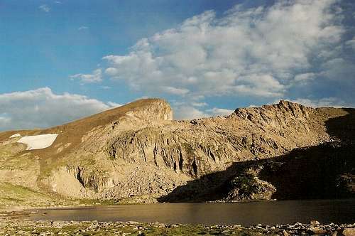
From Washakie Pass, the return to Big Sandy is 11.6 miles and involves an elevation loss of about 2500’.
Side Trip 1-- Pyramid Lake
Two miles before Hailey Pass, there is a north-reaching spur trail of about one mile to Pyramid Lake, which frames outstanding views of surrounding peaks, including several that are seldom visited by hikers or climbers.
 Pyramid Lake-- photo by Nelson
Side Trip 2-- Shadow Lake
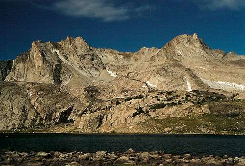
 Cirque of the Towers from near Shadow Lake-- photo by Nelson
From the Fremont Trail before its junction with the Washakie Trail, the Shadow Lake Trail heads east about two miles to its namesake, where there is a backside view of the famous Cirque of the Towers. From there, the adventurous can follow an unofficial route to Texas Lake and to Texas Pass, which is another way into the Cirque.
Side Trip 3-- Baptiste Lake
Details on this trail's location can be found above. The trail climbs about 500' in about 1.5 miles to the lake, where there is an unforgettable view of the massive wall of Mount Hooker. Do note that all of the lake except for the trail-accessible shore lies within the Wind River Roadless Area, part of the Wind River Indian Reservation. Although no one is likely to check for permits here, a permit is required for travel within the area.
Here are some looks at the scenery:

Side Trip 4-- South Fork Lakes
 Lower Lake
From my campsite above the South Fork Wind River, I could see some snowy peaks south beyond Payson Peak, and a look at my map told me I could find the South Fork Lakes up there. There are no established trails to this beautiful alpine basin, but there is a use trail from Valentine Lake, which is along the Bears Ears Trail and requires some climbing (via trail) to reach. I crossed the river and followed a steeply cascading stream all the way up to the lower lake, from which it was easy to reach the upper lake. South Fork Lakes was one of the most astounding places I have ever seen, and it may have been my favorite place in the Winds during my forays into them that summer. It was worth the slippery bushwhacking up the stream from my camp, and it was a great late-afternoon jaunt following an exciting morning out at Hailey Pass, Pyramid Peak, and Baptiste Lake. Don’t miss this place. If I ever go back, I’ll see if I can climb some of the surrounding peaks, which look wonderful.
 Upper Lake
Essential Gear
In addition to the usual for backpacking, I strongly recommend the Earthwalk Press map and guide for the Southern Wind River Range. If you are doing this route before late July, you might want to consider having an ice axe and maybe crampons as well for the passes.