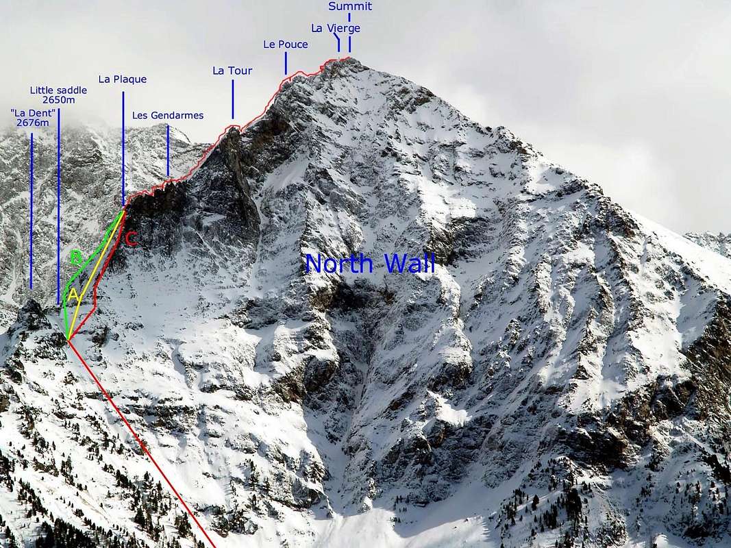
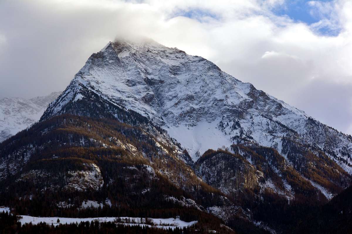
The best among "Becca" routes, the Aosta town mountain for excellence. Aerial ascent with middle-difficulty, by not always rock (dangerous likens black-greenish gneiss by wet rock not advisable). A passage more challenging the triangular plate (120m~) in initial part: three of ascent possibility. Good views to town and to Emilius's North Face.
La più bella via alla "Becca", montagna per antonomasia della Città di Aosta. Salita aerea e mediamente difficile su roccia non sempre troppo buona e con licheni nero-verdastri. Tratto molto impegnativo la placca triangolare di 120 metri circa che presenta tre possibilità di salita. Ottimo panorama sulla città e sulla vicina Parete Nord del Monte Emilius.
First Ascents
(A)
First Ascent from Arpisson Alps in center plate: Amilcare Crétier, Guido Perolino and Giuseppe Riconda, (Jun 20th, 1926).
First in descent: Mountain Guide Giulio Adolfo Ourlaz "Dulo" and wife Aurora Wuillerminaz, (Jul 20th, 1941).
First ascent in solitary: Mountain Guide Angelo Bozzetti, ( 1958, in day from Pila).
(B)
From Pila, bivouac in little saddle 2.650m and plate's NE Edge: Osvaldo Cardellina and Massimo Centelleghe, (Aug 03th, 1967, in two days from Pila).
First ascent in winter: Alberto Sciardi, solo, (Dec 22th, 1985, in day from Pila).
Second replay from Martsaouchy Damon and entire Spur: Vincent Bianchi and Marco Gaida, (Jul 24th, 2006).
(C)
From Saint Salò-Gorres and integral watershed Ridge: Ilario Antonio Garzotto and Osvaldo Cardellina, (Aug 24th, 1969, in day from Saint Salò-Gorres).
LA DENT or BECCA JAG (2.672m)
First Ascent from South little Face: Osvaldo Cardellina and Massimo Centelleghe, (Aug 03th, 1967, in day from Pila).
First traverse (from North to South): Ilario Antonio Garzotto and Osvaldo Cardellina, (Aug 24th, 1969, in day from Saint Salò-Gorres/Pila).
Approaches to Ridge
1) - From Chamolè station of chairlift (2.311m) by path 19c 19 to Chamolè Lake (2.325m), North Replan Pass (2.366m), Comboè "Lower" (2.601m), path to Morion Alp (1.949m; ruins), West Slope of Becca Jag (2.672m) and little saddle (2.650m), (3h'30/4h'00).
2) - From Pila - Saint Laurent (1.800m) or from parking (1.841m) to Chamolè Alp (2.152m), Plan Fenêtre Pass (2.221m), "Lower" Comboè little Valley (2.001m) joint to preceding route (4h'00).
3) - From main route (regional road) to Pila Tourist Station in quota 1.000m~ to Saint Salò-Gorres (1.382m) little Villages and by path 14d to Ponteills Alp (1.697m) and Waterfall (1.800m~) joint the previous route at entry (2.001m) Comboè Valley (3h'30/4h'00).
4) - From main road to Pila, crossroads to Reverier in quota 1.000m~ toward Reverier to Tzat and Lower (1.042m), Ronghachet Bridge and Alp (1.113m), Barmes Alp (1.255m), Martsaouchy Middle and Higher (1.416m); from Higher by path to Plan Croix Alp 1.744m; ruins), Arpisson Lower (1.951m) and Higher (2.010m) and through Eastern Slope of NE Spur (4h'00/4h'30).
5) - From Higher Martsaouchy (1.416m) by path to Plan Croix Alp 1.744m and from quota 1.900m~ direct ascent through wood, grassy slopes and little rocks, crossing in right (W) of "La Dent" (2h'00/2h'30).
1) -Dalla Stazione della Seggiovia di Chamolè (2.311 m) con i sentieri 19c e 19 per il Lago di Chamolè (2.325 m), il Col Replan Nord (2.366 m), Comboè "Basso" (2.601 m), sentiero per Alpe Morion (1.948 m; rovine) e per il versante Ovest de "La Dent" (2.672 m) e la piccola Sella 2.650 metri circa (3h'30/4h'00).
2) - Da Pila - S. Lorenzo (1.800 m) o dal parcheggio (1.841 m) all'Alpe di Chamolè (2.152 m), Colle Plan Fenêtre (2.221 m), Comboè "Basso" (2.001 m) ricongiungendosi alla via precedente (4h'00).
3) - Dalla Strada Regionale per Pila a quota 1.000 m circa verso i piccoli Villaggi di Saint Salò e Gorres (1.382 m) e con il sentiero 14d per l'Alpe (1.697 m) e la Cascata (1.800 m circa) di Ponteilles ricongiugendosi alle vie precedenti, all'ingresso del Vallone di Comboè (3h'30/4h'00).
4) - Dalla Strada Regionale per Pila, bivio per Reverier Dessous a quota 1.000 mcirca, a Reverier du Tzat, Reveriers Dessous o Desot (1.042 m circa), Ponte e Alpe di Rongachet (1.113 m), Alpe di Barme (1.255 m), Martsaouchy e Martsaouchy Damon (1.416 m); da Martsaouchy con sentiero per l'Alpe diroccata di Plan Croix (1.744 m), Arpisson di Sotto (1.951 m) e di Sopra (2.010 m) e per il versante orientale del Contrafforte NE (4h'00/4h'30).
5) - Da Martsaouchy Damon (1.416 m) con il sentiero per Plan Croix (1.744 m) e dalla quota 1.900metri circa direttamente tramite il bosco, pendii erbosi e roccette, passando a destra de "La Dent" (2h'00/2h'30).
APPROACHES to North-northeast Rige: from Marstaouchy Tableland (snowy), true front door to Arpisson Walloon, below the North Wall of Mount Emilius (left); in right (West) the Morion rocky promontory, obliged passage for the aprroaches from Dard Vallon or Ponteilles Waterfall and fron Pila-Resort through the Plan Fenêtre Hill.
Route A Description
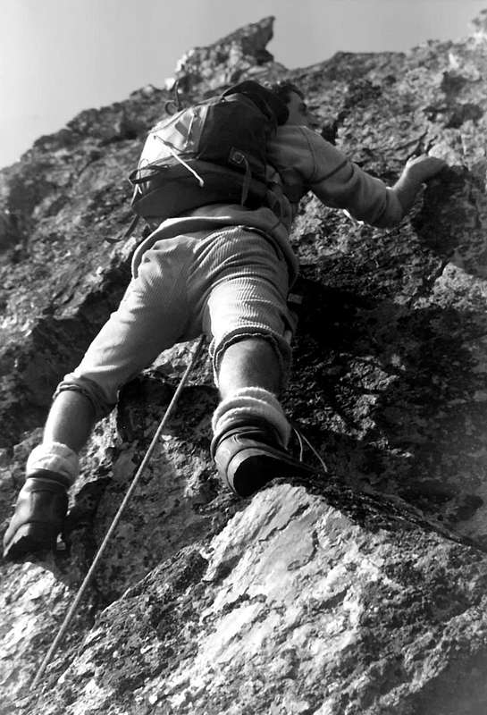
FIRST MOUNTAINEERS ROUTE From Arpisson Alp at base of ridge: to begin of plate (120 meters~) in center and get out by diagonal in right (III°/IV°/IV°+/V°-). To cross the followings gendarmes (three ten height above plate's summit five III°+; one from a height of fifteen meters, III°; one about 18 meters III°+) and to climb up subsequent great plate by inclined slabs but easily as far as "Tower" 2.997m (II°) to go down following window (good views to Noth Face). Still to come through a modest slope flight with smooth surface but easily (I°/II°). To cross others small pinnacles, a small tower in the shape of thumb (III°+ in edge) and a last pinnacle (III°). To end by three lenghts of rope more easy (D-; 11h'00 for the first mountaineers; pitons used: 0).
VIA DEI PRIMI SALITORIDall'Alpe di Arpisson all'attacco del crestone: iniziare al centro della placca di 120 metri circa e uscire negli ultimi 25 metri con un diagonale a destra (III°/IV°/IV°+/V°-). Salire i successivi gendarmi: tre di 10 metri (II°) uno di 15 metri (III°) e uno di 18 metri (III°+); risalire la successiva gran placca di lastroni inclinati ma senza difficoltà alla "Tour" 2.997metri; scendere facilmente alla successiva "finestra" (belle viste sulla Parete Nord). Salire ancora una rampa di modesta inclinazione con placche lisce, ma facili (I°/II°); altre lievi protuberanze (II°/II°+), un torrione a forma di pollice (III°+ sul filo) ed un ultimo torrione (III°). Terminare con tre lunghezze di corda più facili (D-; 11h'00 per i primi salitori; chiodi usati: nessuno).
Route B Description
VARIANT OF LEFT To overcome the initial plate from little saddle 2.650m~ in of left edge and, by traverse in diagonal to East (30/35 meters II°), to climbin in edge watershed (III°+) also in left (III°-) and to reach the of plate summit; after by previous route (AD+; 5h'30; pitons used 7, but by wet rock for night hard storm; bivouac near "La Dent").
VARIANTE DI SINISTRASuperare la placca iniziale sullo spigolo di sinistra della stessa mirando ad un pinnacolo caratteristico, dopo una traversata in diagonale verso Est di 30/35 metri circa. Salire sul filo (III°+) oppure più a sinistra (III°-) e raggiungere la sommità della placca; poi con la precedente via (AD+; 5h'30; chiodi usati 7, ma con roccia bagnata, causa forte temporale notturno).
Route C Description
INTEGRAL BY EDGE WATERSHED OF RIGHT Start from Saint Salò/Gorres for first mountaineers. To climb the triangular plate in edge of right (W), by rock good enough, but with black-green lichens (IV°/IV°+ a passage V°+): From plate summit, absolutely in edge, by ridge to summit (D+; 5h'30 for first ascent; pitons utilized: 0; numerous pauses for photographs; delicate ascent).
INTEGRALMENTE SUL FILO SPARTIACQUE DI DESTRACon partenza da Saint Salò/Gorres. Salire la placca triangolare sull'orlo di destra (Ovest) su roccia abbastanza buona, ma con licheni (IV°/IV°+/ un passaggio di V°+). Dalla sommità seguire assolutamente sul filo la cresta sino in vetta (D+ 5h'30; chiodi usati: 0).
Essential Gear
Mountaineering equipment, including rope of 50 meters, helmet, pitons and friends.
Da alta montagna, corda da 50 metri, casco, chiodi e friends.
Parents refers to a larger category under which an object falls. For example, theAconcagua mountain page has the 'Aconcagua Group' and the 'Seven Summits' asparents and is a parent itself to many routes, photos, and Trip Reports.

 11883 Hits
 86.85% Score
 23 Votes