Foreword
Last Fall I had a cursory introduction to the Gore Range. I took a 3 day trip to Upper Slate Lake to bag Peak L and whatever extra credit I had time for. On the second day I was monsooned on, barely setting foot above tree line. I retreated home, sopping wet with hopes to return, but soon enough winter's icy grip had taken hold of the range. I had the bug though, and made it a personal goal to explore more of the Gores this Summer of 2011.
Fast forward. July, 2011. I'm browsing a website devoted to the study of glaciated terrain in Colorado, hunting down snow climbs. I just happen to run across a photo of a northern aspect of Mount Powell taken by Theron Welch. The line in the photo practically jumps off the screen at me. It looks steep, aesthetic, and best of all: remote. All approaches are long and tedious, requiring bushwhacking, lots of elevation gain, and necessitating an overnight bivy. There is absolutely no beta on the route. Period. We have a recipe for adventure.
Failure only feeds the fire.
My friend Abe and I first attempted the approach from Black Lake. We left late on a Saturday, planning to bushwhack up Black Creek to a pair of lakes just below Cliff Lake at 11,900 feet. We were surprised by the "quality" of bushwhacking above Black Lake. The terrain in this basin is more like a canyon in Jurassic Park than a basin in Colorado. Stepping out of the cars we were instantly targeted by hordes of mosquitoes. In the meadows we battled through vegetation over our heads. When we get into the trees we climbed over piles of deadfall stacked across each other like match sticks. My attire would tell the story best: shoes covered in mud and soaked in water, pants with mud and blood stains up to the knees, grass stains from the knees up. It was quite the ordeal. Realizing that it had taken us around four hours to move the distance of a mile, and with four miles left to travel, we called it and retraced our tracks back to the cars. We arrived broken, bruised, but no less resolute at around 1 AM.
Hold my beer, I'm gonna try something.
In the days after my first attempt I scoured the internet for clues to a better approach. I considered climbing over Mount Powell from Piney Lake, but dismissed that approach as impure from a mountaineering standpoint. I eventually came across an approach from the north, involving some light bushwhacking and much more elevation gain than originally planned. I counted the topo lines: ~7950 feet of total gain. I considered all of the uncertainties of the trip. It involved around 20 miles of backcountry travel, mostly off trail on third and fourth class terrain, and with a heavy (33 lb) pack. Is it even possible? I wasn't sure but decided to have a go at it. I hosted a trip on "Rocky Mountain Madness" to see if I could drum up a partner. I was in luck. My new friend Brian had the gumption to give it a shot as well. The date was set, August 6, 2011.
Dropping in.
Beginning at the Surprise Lake Trailhead, we made quick work of the initial trail to Lower Cataract Lake. About halfway between Surprise and Lower Cataract we broke from the trail and ascended the north slopes of a broad plateau East of PT 13099. The bushwhacking up to the talus slope was easy (by Gore standards at least) and we were soon above tree line and headed for PT 13099.
![Sunrise at the trailhead]() Sunrise at the trailhead
Sunrise at the trailhead![Light bushwhacking enroute to tree line.]() "Light" bushwhacking enroute to tree line.
"Light" bushwhacking enroute to tree line.![Eagles Nest]() Eagles Nest
Eagles Nest![Green Mountain Reservoir]() Green Mountain Reservoir
Green Mountain Reservoir
As we crested the ridge, the views of the Gores to the south were spectacular. However, my attention was focused exclusively on Powell. The route I planned to climb appeared to be in shape and as extra credit there were around ten open crevasses in the lower glacier.
![Powell and friends.]() Powell and friends.
Powell and friends.![First views of Powell.]() First views of Powell.
First views of Powell.![Mount Powell s North Face.]() Mount Powell's North Face.
Mount Powell's North Face.![Crevasse detail.]() Crevasse detail.
Crevasse detail.![Approximate route.]() Approximate route.
Approximate route.
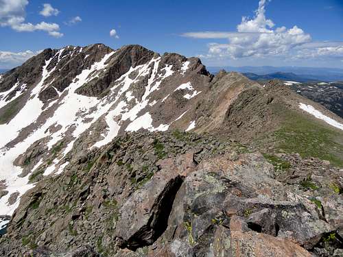
Once atop the summit of PT 13099 we picked a suitable scree gully to begin our descent into the basin and stashed our packs. As part of this trip we had planned to bag Eagles Nest on the approach. The ridge to Eagles Nest from this vantage is Class 4, with mostly sustained Class 3. Of course there are a multitude of opportunities to increase the difficulty, which Brian and I happily took part in.
![Eagles Nest East Ridge.]() Eagles Nest East Ridge.
Eagles Nest East Ridge.![Soaking in the exposure.]() Soaking in the exposure.
Soaking in the exposure.![Crux gendarme on Eagles Nest.]() Crux gendarme on Eagles Nest.
Crux gendarme on Eagles Nest.![Cruising slabs.]() Cruising slabs.
Cruising slabs.![Ridge fun.]() Ridge fun.
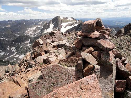
Ridge fun.![Eagles Nest summit cairn.]() Eagles Nest summit cairn.
Eagles Nest summit cairn.![Me and my mountain.]() Me and my mountain.
Me and my mountain.
After a short break on the summit of Eagles Nest we quickly retraced our steps to our packs and dropped into the basin. The line we chose to descend was composed of hard packed dirt and scree and in areas required short exposed down climbs to pass cliff bands. We both agreed that we would have to find another way out. It would be absolutely miserable to climb back up that gully.
![Super goat.]() Super goat.
Super goat.![Backtracking.]() Backtracking.
Backtracking.![Dropping into the basin.]() Dropping into the basin.
Dropping into the basin.Musings of a wanderer.
![Cliff Lake.]() Cliff Lake.
Cliff Lake.![Snowy for August.]() Snowy for August.
Snowy for August.
In the basin, we found Cliff Lake to be largely surrounded by snow and dropped a little lower to another lake with a large rock slab and a patch of tundra near it. Our bivy site was about as picturesque as can be. We set up on a soft patch of tundra amongst a bed of wildflowers, backed up against a large boulder for wind protection. If the viewer were to walk six feet past the boulder they would find a deep, clear pond the size of a community pool, all flanked by several small streams feeding cascading waterfalls below. I spent the remainder of the afternoon in a manner most appropriate for long days in the alpine, relaxing on the slab, drifting in and out of sleep, with the warmth of the sun on my face and a cool breeze blowing down from the surrounding peaks. Throughout the day, the question of whether I could complete the route rung in my head, and I stared silently for long periods wondering this. Due to the nature of our route I had a wide sweeping view of the crux which I determined to be a very steep section of snow and ice immediately below the exit to the summit ridge. Above the couloir it was apparent that there was a short 10-15 foot section of steep rock, possibly vertical. Given the nature of the surrounding rock, it would likely be sheer and loose. The idea of exiting ice of unknown steepness onto rock of unknown difficulty was incredibly unnerving and stuck in my mind for the remainder of the day and night, ultimately invading my dreams and robbing me of needed sleep. A half moon illuminated the cirque throughout the evening, and when disturbed from my sleep by nightmares I frequently pushed my bivy off my face to gaze up at the route.
![Views from camp.]() Views from camp.
Views from camp.![Camp.]() Camp.
Camp.To the top.
After a fitful night of sleep I woke in silence and quickly went about the duties of breaking camp. I stashed my non-essential gear above a large boulder in the basin and as I have come accustomed to, alone and axe in hand, ascended lingering snow fields and grassy benches to the lower apron of the glacier. This aspect gets hardly any sun, and with a good freeze from the night before I was in no hurry at all. I rounded the base of the North Spur, and reaching my first patch of continuous snow up to the moraine, decided it was time to crampon up.
![Morning tundra.]() Morning tundra.
Morning tundra.![Looking up the glacier.]() Looking up the glacier.
Looking up the glacier.
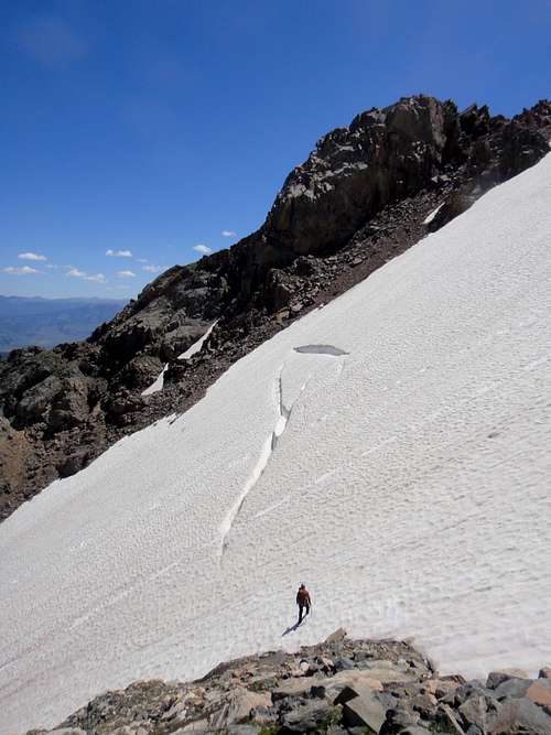
The sun had already softened this portion of snow, but as I reached the shadow cast by the looming face of Powell, it took on the characteristics of beautiful neve. I couldn't believe it, conditions were absolutely perfect. Frenching up the initial slopes of the glacier was absolutely glorious. Approaching the crevasses the slope had already steepened to near 45 degrees and I pulled my second tool. From this point forward I climbed faced in, periodically stopping at large sun cups to flatten out a foot and rest.
![Crevasses on route.]() Crevasses on route.
Crevasses on route.
Eventually the slope steepened to a level where rests were impossible to come by and the now hard ice allowed only front points and partial tool placements. In the middle of the couloir I found a series of irregularities caused by large rock fall, and used these to make for more efficient travel. I distinctly remember the steepest part. I was exhausted, calves burning, clutching my tools in low dagger. Despite my best efforts to determine my position in the couloir I still could not tell if I was near the end. I looked up and a bulge of ice blocked my view. I stepped up as high as possible and leaned back, neck outstretched, attempting to view the next step. I saw nothing but blue sky. I thought for a second that I could be near the exit, but I dismissed the idea. "There's no way this is already over," I thought. However, after another twenty feet of steep climbing I was above the bulge and standing in the moderate exit to the couloir. The headwall I had so feared was exposed as nothing but a steep slope of mud and as I scrambled up I was deposited onto a small patch of sunny, thick tundra amid 270 degree views of my favorite range.
![I m the little dot.]() I'm the little dot.
I'm the little dot.![Top out celebration.]() Top out celebration.
Top out celebration.![Topping out of the couloir.]() Topping out of the couloir.
Topping out of the couloir.
A hasty examination of the ridge revealed a class 2 path to the summit and no major difficulties. Just like that, my fears crumbled and were whisked away. A feeling of pure euphoria took hold and I sat for a while enjoying that perfect moment. My memory can easily recall when I've felt it before. Climbing to the summit of my first mountain, pulling myself off injured reserve to run my first half marathon, free soloing The Snave Direct. It is an overpowering sense of imminent doom, checked by courage and a fierce resolve, finally climaxing in a single moment of affirmation and self satisfaction. From this point a quick hike up the ridge deposited me onto the summit. I read the summit register, which can be quite interesting on the lesser traveled peaks, and signed it. Jason Maki. Houston, TX. Rocky Mountain Madness. North Face.
![Duck Lake.]() Duck Lake.
Duck Lake.![Mount Powell East Ridge.]() Mount Powell East Ridge.
Mount Powell East Ridge.![Peak C. Ripsaw Ridge.]() Peak C. Ripsaw Ridge.
Peak C. Ripsaw Ridge.Way, way down.
Descending from the summit I ran into Brian again, who had spent the day working a route on a northern spur of Mount Powell, and we congratulated each other on our respective conquests. Considering the odds, we had had a very successful day! To descend, we hiked west off of the summit onto tundra and finally linked a couple of low angle glissades down lingering snow.
![Let the glissades begin.]() Let the glissades begin.
Let the glissades begin.![Glissade heaven.]() Glissade heaven.
Glissade heaven.![Checking out a crevasse.]() Checking out a crevasse.
Checking out a crevasse.![Baby crevasse.]() Baby crevasse.
Baby crevasse.![Last of the glissades.]() Last of the glissades.
Last of the glissades.
During the descent we made it a point to get a closer look at some crevasses and finally nailed one last big glissade down to the base of the glacier. From the base we hiked northeast across the basin, aiming for some grassy ledges on the southwest slopes of PT 13099. Along the way we passed typical companions to excursions to the Gore Range. Many small lakes, trickling streams adorned with wildflowers, cascades, and beautiful rock lined our exit from the basin.
![Hiking out.]() Hiking out.
Hiking out.![That s a bad mountain.]() That's a bad mountain.
That's a bad mountain.![Alpine lakes.]() Alpine lakes.
Alpine lakes.
Our line was very narrowly kept to class 4 and loose in several sections. It worked well as an exit, as it bypassed PT 13099, but I would not suggest attempting to descend into the basin via this route. Once atop the ridge we retraced our steps across the talus and back to tree line, taking note that we had to go much further to our right to stay on route than originally thought.
![Exit routefinding.]() Exit routefinding.
Exit routefinding.![Out of the basin.]() Out of the basin.
Out of the basin.
Back on the trail, the rest of the trip was trivial. We made great time back to Surprise Lake where Brian had cleverly stashed a couple brews on the hike in. Refueled, we made the slightly slower and clumsier hike down to the trailhead in just an hour, bringing to an end yet another epic in the Gores.
![Almost to the cars.]() Almost to the cars.
Almost to the cars.


Comments
Post a Comment