
|
|
Mountain/Rock |
|---|---|
|
|
47.95370°N / 121.9232°W |
|
|
Snohomish |
|
|
1210 ft / 369 m |
|
|
Overview
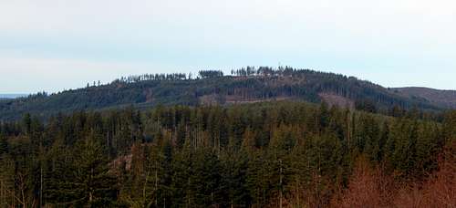
Three Lakes Hill from Reiner Hill (Point 1050)
Three Lakes Hill is covered with a number of logging roads and spurs (about 20 miles worth, by my estimation), which gives one a number of exploring options, whether on foot or bike. I will only attempt to describe the most popular routes on this page, leaving it to you and Google Earth if you decide to play "Choose Your Own Adventure". Note: There is no one spot on Three Lakes Hill that gives up a 360 degree view - if you want to take it ALL in, it will be necessary to visit four different locations on the hill.
As is mentioned above, Three Lakes Hill is located eight miles from everywhere. As you can imagine, this results in numerous possibilities for approaching the trailhead. I will only describe the approach from the west (Lake Stevens/Snohomish area), and leave it to you and Mapquest to find the best and most efficient route for you.
![DNR trailhead for Three Lakes Hill]()
DNR trailhead for Three Lakes Hill
![Optional trailhead for Three Lakes Hill]()
Optional trailhead for Three Lakes Hill
![89th St. SE trailhead for Three Lakes Hill]()
89th St. SE trailhead for Three Lakes Hill. If utilizing this option, just stay on the mainline. In 1.8 miles, it will cross Woods Creek, and at the 2.2 mile point, will intersect with the 'summit road'.
Route
![Three Lakes Hill route map]()
Three Lakes Hill route map. Red lines show walking routes, yellow lines show optional biking routes. Please note that most of the red lines are accessible to bikes as well.
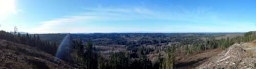
From the DNR trailhead, begin walking up the road, which will pass a large gravel quarry after a short distance. At approximately 0.3 miles, you will arrive at an intersection - hikers will want to stay to the right here. (Mountain bikers can elect to take the left fork here, but it will add considerable distance and elevation gain - the only advantage is a slightly easier grade.) Continue up the road another one-half mile (ignore an unblocked right spur on the way), at which point you will arrive at a fresh spur that has been blocked off with logs. Pass around the logs on the left, then follow the spur almost to its end (a few tank traps on the way). You are now at the east viewpoint, which has some of the best views on the hill - particularly in the evening.
![Three Lakes Hill east pano]()
Three Lakes Hill east pano
![Start of trail segment on Three Lakes Hill]()
Start of trail segment on Three Lakes Hill
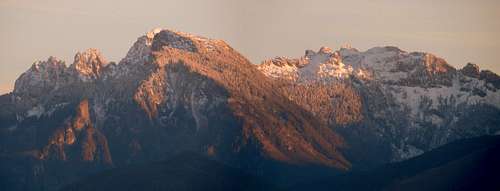
![South pano from Three Lakes Hill southeast summit]()
South pano from Three Lakes Hill southeast summit
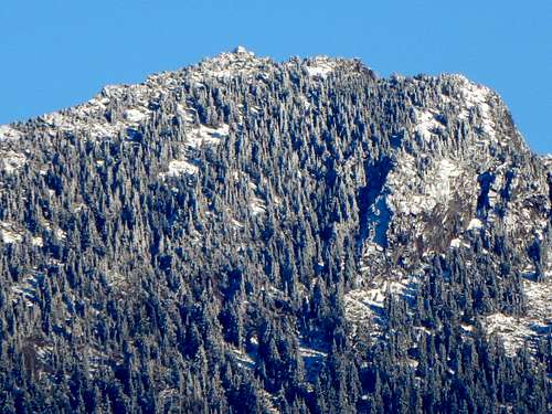
![Com tower on Three Lakes Hill northwest summit]()
Com tower on Three Lakes Hill northwest summit
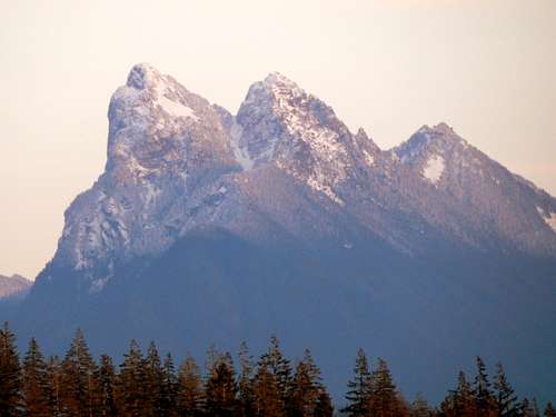
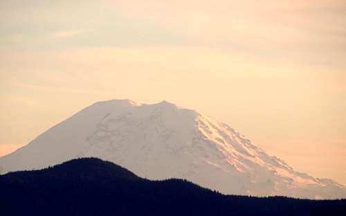
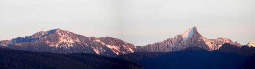
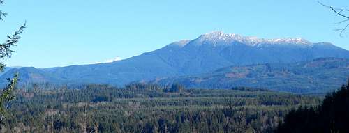
![Looking north from Three Lakes Hill northwest summit]()
Looking north from Three Lakes Hill northwest summit. Twin Sisters on the left, Blue Mountain in the center, Mount Baker on the right. Chitwood Peak can be seen at lower right.
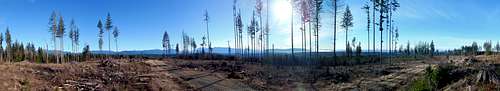
For those who need just a little bit more, there are two west-facing viewpoints that are accessed from a spur just below the northwest summit (you will notice this spur about 500' before the com tower on the way up). Consult the map above if you wish to navigate to one or both of these viewpoints (#1 is by far the better of the two). Visiting either viewpoint will result in an altitude loss/gain of over 200'. ![West pano from West Viewpoint #1 on Three Lakes Hill]()
West pano from West Viewpoint #1 on Three Lakes Hill
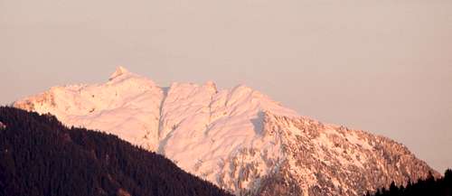
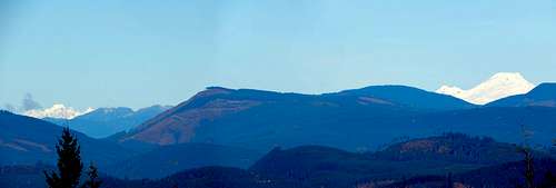
![Looking east from West Viewpoint #2 on Three Lakes Hill]()
Looking east from West Viewpoint #2 on Three Lakes Hill. This is the one spot on the hill where you can get a view of Whitehorse Mountain. Littler Pilchuck on the left, Mount Pilchuck at top right, Explorer Hill at bottom right.
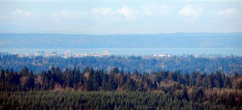
![Downtown Everett from Three Lakes Hill]()
Downtown Everett from Three Lakes Hill
Getting There
From the intersection of Machias Road and Dubuque Road (three miles north of Snohomish), follow Dubuque Road east for 7.7 miles. At this point, Dubuque Road will intersect with South Lake Roesiger Road, and will turn into Woods Creek Road. Continue straight ahead on Woods Creek Road for 2.7 miles. The trailhead will be on the right (west) side of the road, and is marked with a 'Discovery Pass Required' sign (N47 56.595 W121 53.722 Elev. 420').
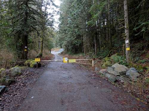
DNR trailhead for Three Lakes Hill
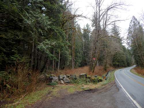
If you are like me, and have a bad attitude towards Discovery Passes, continue 1000' down the road, and park at the 'optional trailhead'. From here, you can walk back to the DNR trailhead, or take a shortcut path, which necessitates jumping over a small creek.
Update: 'Optional trailhead' now also requires a Discovery Pass.
Optional trailhead for Three Lakes Hill
For those who are mountain biking, and want to do something completely different, there is a third possible trailhead, which originates at 89th St SE (just off Mero Road). A parking pass is not required at this 'trailhead'.
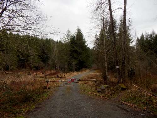
89th St. SE trailhead for Three Lakes Hill. If utilizing this option, just stay on the mainline. In 1.8 miles, it will cross Woods Creek, and at the 2.2 mile point, will intersect with the 'summit road'.
Route
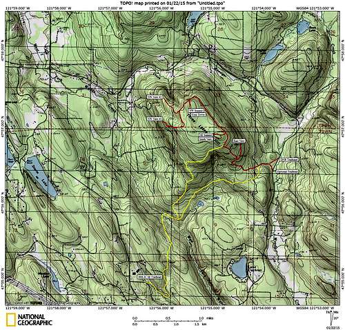
Three Lakes Hill route map. Red lines show walking routes, yellow lines show optional biking routes. Please note that most of the red lines are accessible to bikes as well.
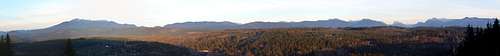
Three Lakes Hill east pano
After you have had your fill of the east viewpoint, backtrack to the main road. Continue uphill another 0.3 miles. You will probably notice a series of electrical junction boxes as you head up this hill - these supply power for a communications tower on the northwest summit. Keep your eye open for number 29030, as this is where you will turn off the road on the way to the summit.
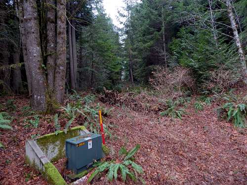
Start of trail segment on Three Lakes Hill
This will be the only 'trail' on Three Lakes Hill. It is about 500' long, and joins two road networks together. It is possible to walk a bike up this trail, and I have done it a few times without difficulty. Follow the short trail to its end, where it will intersect with the 'summit road'. Turn right (north), and walk for about 0.25 miles to a blocked off spur leading off to the left (the spur is not obvious - it is located at N47 56.912 W121 54.766). Follow this spur just a few hundred feet up to Three Lakes Hill's southeast summit. The views are very nice here, as long as you don't mind the few seed trees that have been left behind.
South pano from Three Lakes Hill southeast summit
For most hikers, these views will be adequate. However, if you want more, head back to the 'summit road', and continue north towards the northwest summit. In about one mile of fairly flat road, you will arrive at the northwest summit, which is marked by a large communications tower. The views here are a little disappointing, but it is the one spot on the hill that provides a north-facing view.
A quick note for the prominence peakbaggers who might be reading this: I made a feeble attempt to determine which of the two summits was the highest. I wandered around a bit with the GPS, and the result was exactly the same for both summits. I'm really not interested in banging around in the brush to find the highest stump, so I'm leaving it to someone else to find the high point. All this to say, if you feel you need to 'summit' the hill, go to both high points.
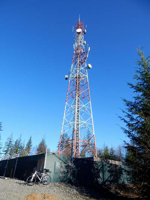
Com tower on Three Lakes Hill northwest summit
Looking north from Three Lakes Hill northwest summit. Twin Sisters on the left, Blue Mountain in the center, Mount Baker on the right. Chitwood Peak can be seen at lower right.
West pano from West Viewpoint #1 on Three Lakes Hill
Looking east from West Viewpoint #2 on Three Lakes Hill. This is the one spot on the hill where you can get a view of Whitehorse Mountain. Littler Pilchuck on the left, Mount Pilchuck at top right, Explorer Hill at bottom right.
Downtown Everett from Three Lakes Hill