
-
 31839 Hits
-
 89.77% Score
-
 30 Votes
|
|
Area/Range |
|---|---|
|
|
42.72400°N / 110.776°W |
|
|
Hiking, Mountaineering, Scrambling |
|
|
Summer |
|
|
10907 ft / 3324 m |
|
|
Overview
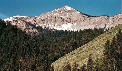
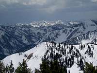 Salt River Range-- by wyopeakMike
Running for almost eighty miles north-south near the edge of west-central Wyoming, the parallel Salt River (west) and Wyoming (east) Ranges make a long, remote alpine tail of the Greater Yellowstone Ecosystem. They are the least-visited of the Yellowstone region’s mountains, but locals and smart visitors know that these gems have just about everything that the famous ranges do and some things that they sometimes sorely lack--- peace and quiet that don’t require epic backpacking to attain. There is no officially dedicated wilderness out here, but much of it is so remote and little-used that it is a de facto wilderness. Hiking, climbing, horseback riding, whitewater rafting, hunting, and fishing opportunities attract outdoor enthusiasts of all different types. And did I mention how quiet and peaceful it is out here?
Mining, logging, and livestock grazing have all occurred in these mountains. From the 1960s through the 1980s, the timber industry engaged in extensive clearcutting and road building on the eastern slopes. Livestock grazing still goes on (look for cattle low and sheep high), though not to the meadow-trashing extent it once did. The Salt River Range is a narrow range, and a strong hiker could hike from a trailhead on one side to a trailhead on the other in one day.
Nevertheless, there are many fine hiking and backpacking destinations-- Crow Creek Lakes and Wagner Lake are two good examples-- that can make bases for climbs to prominent summits such as Mount Fitzpatrick and Mount Wagner.
 by wyopeakMike
The range is part of what is called the Overthrust Belt in western Wyoming. Millions of years ago, the land was pushed eastward so that it “crumpled” in parallel configurations. Hence, this mountain range. Easily seen from U.S. 89 to its west and better-known than the Wyoming Range, this range consists of long reefs composed of sedimentary rocks.
There are several large summits, and some of them have a classic pyramid shape from certain angles. An odd feature of this range, due to the tilting and the rock type, is that lakes below the eastern faces of the higher peaks drain westward through subterranean channels, and the water reemerges through springs on the west side.
In general, there are more lakes in the Salt River Range than there are in the drier Wyoming Range, but neither range could be called a lake-studded wilderness along the likes of the Beartooth Mountains or the Wind River Range.
 From Salt River Pass-- by mtybumpo
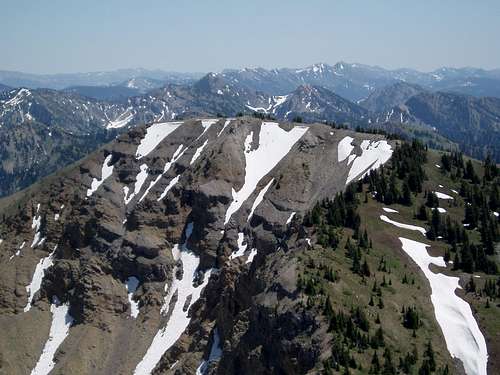
 Mount Fitzpatrick-- by gjagiels
Getting There
Listing all means of access to this vast area would be quite a task, but I will discuss a few major spots. On the west side, just south of Smoot, turn east on County Road 153. After a mile, the pavement ends and the road becomes the rougher Forest Road 10208. Follow the road for five miles to Cottonwood Lake, where there is a campground. At the end of the road, there is a trailhead. Park here for the 3.5-mile (one way) hike to Wagner Lake (Salt River Range), where you can try climbing Mount Wagner or other nearby summits. Also on the west side, just north of Afton, a road leads to the Swift Creek Trailhead, a starting point for routes on Mount Fitzpatrick and Rock Lake Peak. The Greys River Road, on the east side of the range, is an adventure in itself. There are several trailheads along the road and its spurs. Please read the next section for a more detailed account of this spectacular mountain journey.
Greys River Road
Start in Alpine, Wyoming, and head south on the Greys River Road. This road is a little rough and bumpy in places, but you can travel it with almost any passenger car. In good weather, this road gives wild scenery and a remote feel that only the truly dead of heart will fail to appreciate.
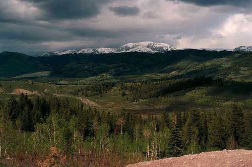
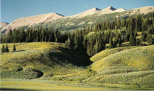
 Salt River Range from Greys River Road
It is about 60 miles from Alpine to Tri-Basin Divide, a few feet north of which the Greys River begins as a trickle in some gorgeous meadows. Look for the sign saying “Greys River--- Watch Me Grow” and reflect on how the river has changed since you left Alpine (or, if you’re heading the other way, get yourself ready). Tri-Basin Divide is also where the road splits three ways--- south, east, and west--- and leads to other fine Wyoming destinations. Along the way there, you get to enjoy what I like to think of as the "real" Wyoming-- classic mountain country with canyons, meadows, wildlife, rugged peaks, and no crowds. This country is so big, beautiful, and remote that you will feel as though you are on safari in some undiscovered territory despite the fact that you're on a signed road. The first few miles of the road take you through a dramatic rapids-filled canyon. Then the scenery opens up as you travel well above wildflower meadows and the river's east banks while pyramid-like peaks of the Salt River Range compete for your attention. Watch for cattle, but watch for moose, too, and look out for the ground squirrels-- they deserve a break (and brake), too.
 Wyoming Range from Greys River Road
As trees begin to block your views of the Salt River Range and the road gets a little rougher, the Wyoming Range comes into view. Some particularly beautiful areas are around Box Canyon Creek, where a great trail accesses the crest of the range, and Poison Meadows, where there are stunning meadows of gold and purple in July. All the while, take time to enjoy the changing faces of the Greys River. The side trip to McDougal Gap does not take long and is worth the time. You can approach Tri-Basin Divide from La Barge or from U.S. 89, too. There is also a way from the Pinedale area by heading over McDougal Gap, but I have not been that way yet and cannot describe it. The way from 89 is nicer and easier than the La Barge way, but it is still nowhere near as scenic as the Greys River way.
Red Tape
There is not too much trail maintenance or signage out here. Know what you are doing before you venture out into these mountains. Hunting is popular in the fall--- hikers and climbers might want to stay away at those times. Most hunters and some hikers are very responsible, but there are accidents every year all over the country. The Greys River Road is unplowed in winter.
Camping and Lodging
There are several Forest Service campgrounds along the Greys River Road. They are primitive sites (no water, no flush toilets). Fees for them, if any, would be small. Dispersed camping opportunities are delightful and virtually limitless. Camping is available at many of the trailheads on the west side of the Salt River Range. The towns of Afton and Alpine provide all services.
Books and Maps
Most of the area lies within the Bridger-Teton National Forest, and contacting that agency for a map would be a good idea. The forest map will not show the topography, but it will identify the USGS quads you should have for hikes and climbs out here. Alternatively, get DeLorme’s Wyoming Atlas and Gazetteer, which does show topography and has the added benefit of covering the entire state; it is not, however, suitable as a hiking map. Falcon Publishing has Hiking Wyoming, which details one good hike in the range, and Wild Wyoming, which gives useful travel information, overviews, and trip suggestions but is not so good with trail descriptions and maps. Thomas Turiano’s Select Peaks of Greater Yellowstone is the climbing Bible for the region, and it is available at Amazon.com. The book covers several Salt River Range peaks not on SP, and it has extensive information about the region's natural and human history.
Contact Information
Greys River Ranger District 617 North Washington St. P.O. Box 339 Afton, WY 83110 307-886-5300 Fax: 307-885-5339