Trip Report
Shirley and I decided to do the
Northeast Face, Left route on
Warbonnet as a "warm up" climb during our first outing to
Cirque Of The Towers . Although there was no topo for the route (and only a short, vague paragraph describing the route in Kelsey's book), we figured that at grade II, 5.7 "how bad could it be"? Our concern was the fact that on both our day 1 in Pinedale, WY and day 2 approach we got nailed by early afternoon thunder/lightning storms. Both times like clockwork at 2pm....but again, given the fact that it's only "grade II" and we're practically camped next door to it, "how bad could it be"? The climb seemed to be a perfect apetizer climb after the approach day, made painful not so much by distance or elevation gain - those were actually pretty mild by Olympics or North Cascade standards - but by the two bear canisters in my pack and 7+ days worth of food. Additionally, we thought that the
north and
northeast faces of the mountain looked quite handsome as did the summit ridge.
Woke up at about 7 or 8 am, got some food in us (freeze dried Granola - add water and it tastes like cereal - or so they say, I thought it tasted like fecal matter) and started hiking towards the
obvious snow gully between The Plume and Warbonnet's NE face. As the gully is in the shade, snow was firm to the point that we decided to make use of crampons we hauled in all this way. Few hunderd feet up the
gully , we encountered the first of several painful slab crossings. The snow cover partially protrudes up onto the steep slab making for neither a secure snow nor a secure slab section. I cramponed and dry tooled my way up the thing and decided to hip belay Shirley. To all those who think we're overly conservative....well, (I gave this some thought), scenarios of climbing with a friend vs. a loved one are quite different. In the former, one focuses on himself/herself not messing up and dying; in the latter, one focuses not just on himself but also on the partner much more so than in the other case. Anyway, atop this 20 foot slab section, we encountered more snow followed by more slab. This sequence was repeated several times. Approximately, 200 feet below the top of the gully, we moved left onto class 4 rock (wet and mostly loose) and climbed it to the top. The gully is unpleasant and a bit scary since should something come down from the top - given the rock quality, not an unlikely scenario - you're wearing a big target sign on your body. Book claims that "4th class ledges" on the opposite side offer an alternative (gully was more direct from our camp site). The approach also took us much longer than we expected. It is now close to 11 am.
Once
at the col or notch, guidebook copies firmly in hand, the head-scratching begins. "Scramble left from Plume notch to a right facing dihedral and follow it for a few easy pitches. Above a short, left-facing corner continue up, then right, for a few 5.7 pitches to the rightmost chimney...head up the chimney...." is pretty much what you get from Kelsey. Well, there are a
few dihedrals on the left side of NE face. Sure, some of them immediately look like they wouldn't go below 5.9, but that still leaves more than one option. In the end, I shoot straight up 4th class slabs till I arrive at the base of a steep wall (atop large ledge) 200 feet above the col. From here, I look right and then traverse left then up an easy and short dihedral (maybe 5.6?). Things are
pretty easy so far - just as the book suggests. No obvious signs that we're on or off route (
abundant flora suggests the latter).
Pitch three, I follow a sloping 2 foot ramp up and right then decide to shoot up a crack/flake system. This brings me to some difficult terrain about 30 feet up. "Shit!". Decide to traverse right then downclimb. The blessing of climbing on twin ropes is that when in a squeeze, you can (probably shouldn't but can) switch to a "double rope" mode - i.e. toprope your second for the pendulum. Eventually reach a wet, mossy groove and easier climbing. I belay Shirley from an "alcove". The presence of rap slings here again yields no clue as to whether or not we're on route - has the previous party bailed here because they too screwed up? Shirley follows the pitch and pendulums across on the "free" strand of rope. The mountains ring with the stream of profanity that ensues. But all is good. I start up the
fourth pitch. Here the terrain steepens significantly. Few feet above our belay, going gets progressively harder. Voices in my head (normally hear them only at work or when scared or when not drinking) begin talking sh.. - "you're off route!!" and my all time favorite "you're gonna die!!". This mental state does not make climbing any easier. Perhaps the pitch is only a 5.7, but with mossy cracks as repositories for pro, lichen-covered and a tad loose rock for foot and handholds I feel pretty sketched. The pitch (as I recall) consists of flaring hand and finger cracks and flakes. I keep on climbing as there's really no belay options. A ray of sunshine illuminates my depressed state of mind as a piton appears at my face level!! I can move it with my fingers, it's capacity to hold a fall is crap but it's the first sign that we're on route!!! Some route anyway...I hear Shirley inform me of the 10 remaining feet of rope. Above, I do see the terrain kicking back. I'm out of rope and still a few feet short. I ask Shirley to take me off belay and to move up a few feet. Soon I'm on a
narrow ledge at the mouth of a dark, mossy chimney. Shirley comes up and looks at me with a smile - she too has seen the piton.
Despite its unattractive look, I'm much tempted to take the chimney thinking that salvation is just over its horizon but instead I look at Kelsey's "description" of the route which insists on a rightward traverse high on the route. There is a reasonable looking crack or 6" groove heading right and slightly up from the belay. Decide to take it. 20 feet later I have the option of taking a shallow finger crack up or downclimbing righward. We hear the sound of thunder in the distance though the sky to the NE looks clear. My mind is made up. I downclimb, traverse a bit more right and follow easier ground up. I encounter another piton (and a fixed nut or something). Overcome with joy, I reach a belay at the mouth of a
much less prominent chimney...what actually looks like a series of short (~20foot)
chimneys. The
chimney pitch is mostly easy after 1st awkward move into it. There's a pretty pleasant finger-to-hand crack up higher and right of chimney.
We top out and see the
incoming storm over Big Sandy Lake. The
wind picks up. We don't have much time.
Summit photo snapping takes a back seat to getting down. We get quite a light show over Big Sandy Lake as we begin dropping down the south slopes (class 2-3). The sky goes dark and visibility drops to crap. We're about 500 feet below the summit when the rain starts. Find a "cave" under a house sized boulder. For the next 2 - 3 hours we have quite a
show : lightning, thunder, rain, and hail. It's not the distant flashes that are scary - it's those that seem to come from all around indicating their proximity to our position. Eight pm approaches and with it goes much of the daylight. With the frequency of lightning down to almost zero, we crawl out of our shelter into drizzle. The descent continues made more difficult by slick rocks on the class 3 sections. We reach the Sundance-Warbonnet saddle and begin dropping down the talus toward the area between Arrowhead and North Lakes. Just above the lakes, we turn left hoping not to lose all the elvation we'll need to regain to go over
Jackass Pass. Bad idea. Car sized escalating to house sized boulders are in our way. Hopping, dropping, and scrambling makes for slow progress toward Arrowhead. It's dark now and in a moment of a moronic spell in the morning I only tossed in one headlamp into our pack. Shirley goes first illuminating the way and I try to follow her footsteps. Boulder hopping over slick, dark rock is fun stuff (that is once you're home and reminiscing about it over some milk and cookies)! Finally, the mean size of the boulders decreases to TV-sized and we're traversing over Arrowhead Lake. Soon thereafter we're descending into the Cirque looking for our tent in a moonless, wet night.
Our plans to climb something the next day were put on hold. We slept in and focused on drying out our junk (ropes were soaked). In retrospect, the late start on climb day was the mistake. Thankfully we were not punished as the rain and storm held off until we were on our way down! Once again the rains arrived that afternoon (and again at night). The next day we climbed
Wolfs Head East Ridge route (after an uncertain start in the morning once again due to building clouds). This was a fun, mostly stress-free climb (other than keeping a constant eye on the sky) on perfect rock. Five somewhat wet days in the Cirque proved enough. We hiked out and went for some dry cragging at Devil's Tower. We'll be back next year to do
Pingora and hopefully Shark's Nose.
Photo Essay
![Warbonnet Peak]() Warbonnet Peak from camp on a stormy afternoon.
Warbonnet Peak from camp on a stormy afternoon.![Warbonnet Peak]() Northeast face of Warbonnet.
Northeast face of Warbonnet.![Warbonnet Peak]() Warbonnet in the morning.
Warbonnet in the morning.![The Cirque Of The Towers]() Pingora and The Cirque from approach to Warbonnet.
Pingora and The Cirque from approach to Warbonnet.![Northeast Face, Left]() Shirley in the snow gully on our way up to the route.
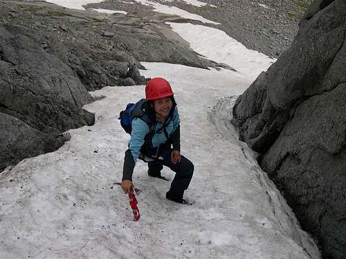
Shirley in the snow gully on our way up to the route.![Northeast Face, Left]() Shirley approaching the saddle and the start of the route.
Shirley approaching the saddle and the start of the route.![Northeast Face, Left]() Happy Shirley at the Warbonnet-Plume Col...base of route.
Happy Shirley at the Warbonnet-Plume Col...base of route.![Northeast Face, Left]() Shirley nearing the top of pitch 2.
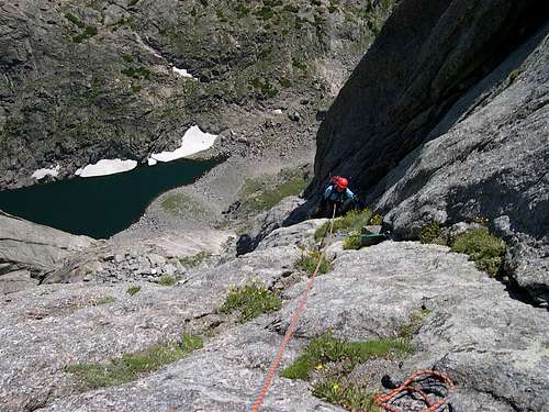
Shirley nearing the top of pitch 2.![Northeast Face, Left]() Looking back at Shirley from near the top of pitch 3.
Looking back at Shirley from near the top of pitch 3.![Northeast Face, Left]() Shirley on pitch 3.
Shirley on pitch 3.![Northeast Face, Left]() Shirley belaying atop of pitch 4.
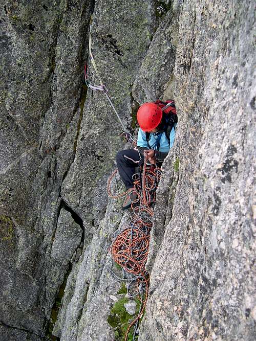
Shirley belaying atop of pitch 4.![Northeast Face, Left]() Micro scenery on pitch 5.
Micro scenery on pitch 5.![Northeast Face, Left]() Macro scenery on pitch 5.
Macro scenery on pitch 5.![Northeast Face, Left]() Shirley nearing the top of pitch 5.
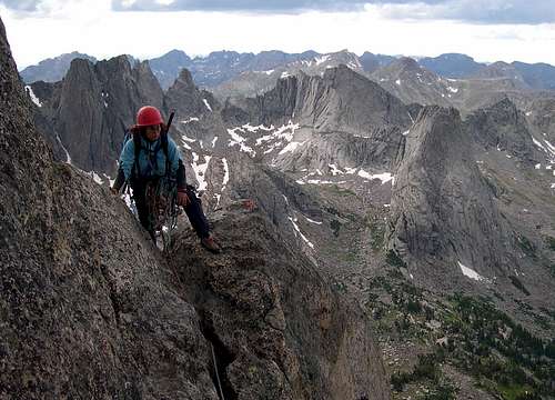
Shirley nearing the top of pitch 5.![Northeast Face, Left]() Shirley at the belay atop pitch 5.
Shirley at the belay atop pitch 5.![Northeast Face, Left]() Looking up at chimneys of pitch 6.
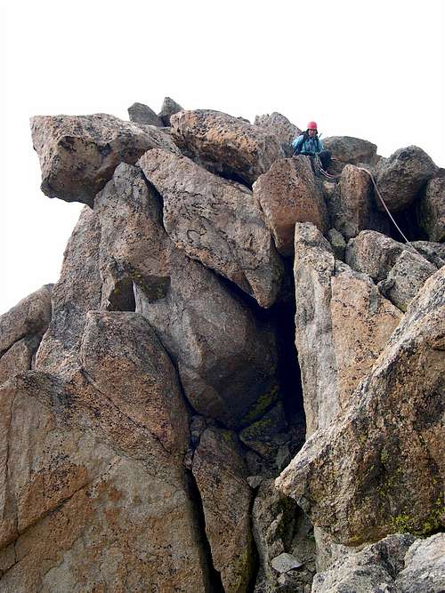
Looking up at chimneys of pitch 6.![Northeast Face, Left]() Looking back at Shirley from the final chimney pitch.
Looking back at Shirley from the final chimney pitch.![Northeast Face, Left]() Shirley topping out on pitch 6 just below the summit.
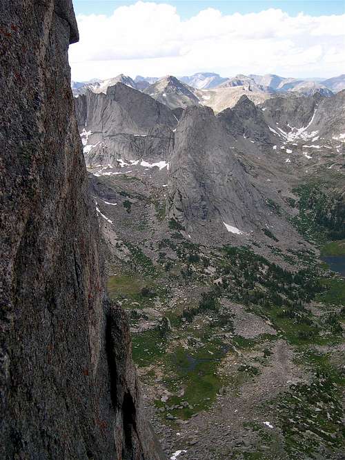
Shirley topping out on pitch 6 just below the summit.![Cirque Of The Towers]() More views of Pingora.
More views of Pingora.![Warbonnet Peak]() Shirley 30 feet below the summit.
Shirley 30 feet below the summit.![Storm Coming In]() ...Pop onto the summit & see a storm coming in.
...Pop onto the summit & see a storm coming in.![Northeast Face, Left]() Shirley starting down from the summit.
Shirley starting down from the summit.![Warbonnet Descent]() The remnants of the storm from our descent.
The remnants of the storm from our descent.![Warbonnet]() Views of Warbonnet from the Cirque on the following day.
Views of Warbonnet from the Cirque on the following day.![Cirque Of Towers]() Shirley admiring Warbonnet the following day.
Shirley admiring Warbonnet the following day.![Cirque Of Towers]() Looking back at Warbonnet from Wolfs Head two days later.
Looking back at Warbonnet from Wolfs Head two days later.![Cirque Of Towers]() Another shot of the photogenic Warbonnet from Wolfs Head.
Another shot of the photogenic Warbonnet from Wolfs Head.![Warbonnet Peak]() The "backside" of Warbonnet on our hike out.
The "backside" of Warbonnet on our hike out.Route Beta Shots
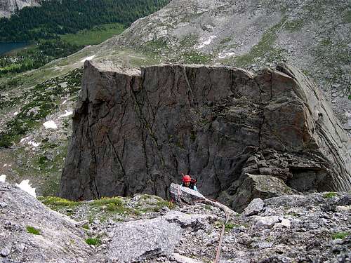
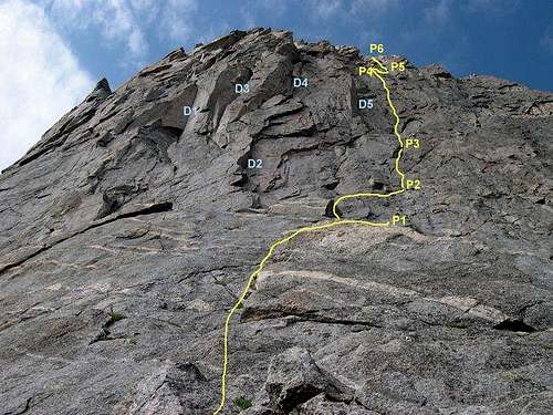
![Northeast Face, Left]() Northeast Face, Left (5.7) route on Warbonnet.
Northeast Face, Left (5.7) route on Warbonnet.![Northeast Face, Left]() Northeast Face, Left (5.7) route on Warbonnet from the base.
Northeast Face, Left (5.7) route on Warbonnet from the base.![Northeast Face, Left]() My poor excuse for a topo.
My poor excuse for a topo.
Comments
No comments posted yet.