
|
|
Canyon |
|---|---|
|
|
41.20275°N / 111.92474°W |
|
|
Hiking |
|
|
Overview
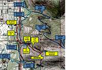
Area Map
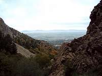
City of Ogden as seen from Waterfall
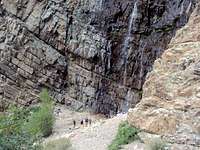
Crowds around the waterfall
The most common way to reach Waterfall Canyon is from the 29th Street Trailhead located (41.210624,-111.931978) for a 1.37 mile hike to the falls. Inexplicably, the trail to the waterfall is rated as “difficult” on most websites, but is actually a “moderate” YDS Class 1 hiking trail. Total elevation gain to the waterfall from Ogden is ~1,200 feet and takes 45 minutes one way for medium hikers from the 29th Street Trailhead.
The first half of the hike up to the Bonneville Shoreline Trail (BST) from the 29th Street Trailhead is a steady rise up the side of the hill past scrub oak and sage brush. Once at the BST there is a small bridge and the trail splits left/right/up the hill. Left and Right are for BST; Waterfall Canyon is the rocky center trail. Continue up the canyon on the beaten path through the forest for about a ½ mile. The trail is loaded with rocks and a real ankle breaker if you aren’t careful. As you approach the Waterfall, you will hear it long before you see it. Near the waterfall, there is a small stream to cross and then the trail goes sharply up to the waterfall. The waterfall, in and of itself is a pretty destination…you just don’t see too many 200 foot waterfalls in Utah. Grab a rock, take a break, and return the way you came.
True professionals can climb the rocks to the right of the waterfall and continue to a second waterfall. The trail can be part of a loop that crosses Malan Basin/Peak, down Taylor Canyon to 27th Street and back to your vehicle on 29th Street. You could also follow the trail high up the mountain and summit Mt Ogden.
Summer is the worst time to visit the Waterfall. In addition to being hot, the lower trail is crowded with mountain bikers and slow, noisy hikers. On summer evenings the hike is a virtual conga line of teenagers, retirees and guys taking their girls on cheap dates.
Waterfall Canyon is a good winter destination and you can climb it with or without snowshoes. You will most likely have the canyon pretty much to yourself and it becomes nice, quiet, short winter hike.
The cliffs above the waterfall are popular climbing destinations but can be dangerous. There is a small, informal shrine near the waterfall dedicated to a teenager who fell and died climbing the cliffs in 2010. The waterfall partially freezes in a huge sheet during the winter and makes the waterfall scalable for ice-climbers. Winter hikers should use caution next to the waterfall as ten pound chunks of ice routinely fall off and can brain you where you stand.
Getting There

Bridge into Waterfall Canyon
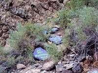
Monument to Climber who died climbing the Rocks next to the waterfall

Rocky route to Malan Peak out of Canyon
The trailhead on 29th Street has a large parking lot with around a 30-car capacity. It has both water and bathroom facilities available. No motor vehicles are allowed on the trails but watch out for mountain bikes especially on the exercise trail and up on the Bonneville Shoreline trail. The trailhead is rarely full in the winter but gets near capacity on summer evenings. The Info Kiosk has a poster map of the area and some historical info about the trail.
From I-15, take exit 341 (31st Street), follow the signs for Weber State University/Hospital (East, toward the mountains). Continue on 31st to Harrison Blvd, go left to 29th Street, Turn right and follow 29th Street to the Trailhead.
Red Tape and Camping
Trail from 29th Street

The Waterfall as first seen from the trail
Red Tape:
The trails are on a mix of USFS, and/or private property (TR Guest Ranch) property. The preponderance of the hike is privately owned, but the owner is pro-hiker and gives blanket permission...Try not to trash the place. The falls themselves are on private land; there's been issues of jurisdiction during emergencies because everyone assumes it is USFS. .
The TR Guest Ranch owner has been making some changes. Most recently, he's installed a couple of zip-lines(one across the canyon at BSL junction and one near the falls), put "do not enter" warning signs next to the Via Ferrata trail, and asks everyone to bring some type of ID.
No Fee for hiking. Dogs and horses are allowed. Campfires are restricted and fire is a real danger.
Camping:
None in the immediate area since the hike is so short.
Flora and Fauna

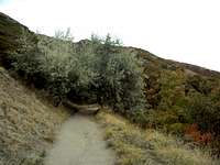
The trail in the canyon
The area around the trailhead has the usual Utah wildlife including Deer, Elk, Rabbits, squirrels, and the like. It is an excellent bird-watching area. Mosquitoes are negligible but the flies can be annoying. Like everywhere else in Utah, watch out for rattlesnakes.
The west face of the Wasatch Mountains are hot and dry in the summer and covered with sage brush and dry grasses. The canyons are mostly made up of Gambel Oak, Canyon Maple, and Water Birch forests.
The area gets lots of snow during the winter, the lower trails are pretty well beaten down but the trip to the waterfall is an entertaining snowshoe route.
External Sites
www.facebook.com/MountOgdenViaFerratawww.ogden-ut.com/hiking.html
www.utah.com/ogden/hiking_trails.htm
www.localhikes.com/Hikes/Waterfall_Canyon_7160.asp
www.weberpathways.org