
-
 26250 Hits
-
 78.8% Score
-
 10 Votes
|
|
Route |
|---|---|
|
|
48.53780°N / 121.1331°W |
|
|
Technical rock and glacier |
|
|
A few days |
|
|
5.8 |
|
|
Overview
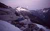
As you drive east on Washington's Highway 20 into the North Cascades, you'll pass through Rockport State Park and begin descending toward the town of Rockport itself. For a hundred yards or so, you'll catch a tantalizing view of a large, sharp, glaciated peak far ahead, through a gap in the mountains. You're looking E., about 21 miles up the Skagit River, Cascade River, and Marble Creek to the west face of Eldorado Peak. Splitting that face, rising 2,800 feet from well above timberline directly to the summit, is Eldorado's West Arete. Though it's inconsistent in its technical difficulty and the quality of the rock, the setting is hard to beat: high above a forested canyon and guarded by steep glaciers. If your idea of wealth is the ability to disappear from civilization for a few days to push non-stop through a variety of challenges (not the least of which are distance and gravity), then the West Arete may be your personal City of Gold.
[Note: All my photos from the climb are from a single trip, July 22 – 24, 1994.]
 |  |  |
Approach
Nelson and Potterfield's Selected Climbs in the Cascades rates both the Sibley Creek and Eldorado Creek approaches as Grade IV. I've always used the Eldorado Creek route; Sibley Creek requires too much sidehilling for my ankles. From the gravel parking area before the gate on the Cascade River Road, find a log river crossing [Any new info you have on the best crossing would be appreciated on the Eldorado Main Page.] and ascend unmarked climbers' track through steep forest, then talus left of Eldorado Creek. (Note that Eldorado Creek is one valley E of Eldorado Glacier.) In the open upper basin, gain the ridge that forms the left boundary and find the rock gully that takes you down into the Eldorado Glacier basin, below the glacier.
To this point, you've been on the standard approach. Now, instead of hiking up to the glacier, traverse the basin under it 1.5 miles to the far edge. Aim for the saddle just right of The Triad. Glacier-polished ledges just below the saddle provide sites for a tent or bivy at about 6400 feet.
Gaining the saddle (6720+ feet) requires some class 3 climbing on ledges that zigzag up to the top. If I was still carrying a big pack here, I might want a belay, but felt OK with a summit pack. The glacier on the opposite (W) side comes right up to the saddle. Start walking downhill, bearing to the right. It's fairly steep; not having crampons here in late season might end your trip. The grade eases some about 1000 feet down. Exit right and contour the sidehill at about 5500 feet for about 0.6 mile to the base of the small glacier that takes you up to the foot of the arete at 6000 feet.
 |  |  |  |  |
Route Description
The foot of the arete is split into two “toes.” Start up the closer, SW toe to where it flattens, then take a chimney / gully a couple of pitches to the main crest. Enjoy class 4 and easy-to-moderate class 5 climbing up the crest for about a thousand feet to the towers. This narrow, steep section requires some deviation from the crest. Bear left around the first tower to find youself looking into a steep, deep notch in the N side of the arete. The crux of the route is the 5.8 traverse left into the chimney on thin face holds, then climb the easy chimney to the notch.. Before leading across the face you can improve your odds by climbing straight up the ramp in front of you to place pro high over the traverse.
Climb through the ridge to the S side and look ahead to a vertical crack system that takes you to a big ledge around the S side of the next tower. The tower section is far more difficult than most of the climb, but it's short and solid. Between the second tower and the next step, reach a broad ledge that crosses the arete. We ran out of daylight here at about 7800 feet, and were forced to bivouac. Leaving the left corner of the ledge to continue up, our main impression was of air: both the air under our heels above the glacier far below the N face of the arete, and the air between the loose blocks that we climbed on up the short, steep face. Above the step, easy climbing leads to a broad, easy gap in the arete. Head for the huge, gentle ledge in the face of the mountain ahead and follow it up to the right, then straight up again. The ledge was snow-covered when we climbed the route in July, 1994.
You're on the home stretch now, with about 600 feet of easy, but sometimes loose blocky climbing up the crest to the summit. Enjoy the views.
From the summit, descend the standard E ridge route and swing S to the Eldorado Glacier. The descent back to camp under the saddle is straighforward, given good visibility. Even with our unplanned bivy 2/3 of the way up the arete, we were able to reach the car before dark. (On another trip Derek Franzen & I had to navigate by compass on the flat Eldorado Glacier in fog. It may help to have some bearings and distances already noted.)
 |  |  |  |  |
Essential Gear
A full set of chocks and slings for a day (at least) of class 5 rock. Ice axes, crevasse-rescue gear, maybe crampons. We wore rock shoes and carried boots up the route. Carrying bivy gear on the route may make the difference between comfort and misery, but it may also make the difference between having to bivy and finishing the route in a day, if you're faster than we were. Carry the USGS 7.5-minute quad maps for Eldorado Peak and Forbidden Peak.
Camp / Bivouac
For the standard route the best camps are in the upper Eldorado Creek basin or on the ridge that separates it from the Eldorado Glacier / Roush Creek basin. For the West Arete, we wanted to camp closer to the route. Drop down off the ridge and traverse under the Eldorado Glacier to the far side. There, just under the saddle in the ridge between the Triad and Eldorado, we found smooth granite ledges suitable for a tent and bivy sacs.
Our unplanned bivy on the arete was higher than The Triad, around 7800 feet. We were comfortable enough to sleep there a little, in just our clothes & packs, but we were short on water, and snow was just one pitch above.
 |  |