


Comments
No comments posted yet.
|
|
Trip Report |
|---|---|
|
|
44.08200°N / 113.733°W |
|
|
Nov 30, 1999 |
|
|
Hiking, Mountaineering, Mixed, Scrambling |
|
|
Spring, Summer, Fall, Winter |
This was my first outing with SuperDave and I was looking forward to hearing about his adventures. I was originally planning on Lost River Peak, but we decided on Leatherman since neither of us had done it yet. We decided to do this trip in a long day and we headed out at 4:30am and reached the trailhead up Sawmill Gulch at about 8:15am. I parked the Jeep (a typical Boise County vehicle complete with spare tire on top, no air conditioning, various parts duct taped and wired, and excellent off road ability) near a rocky out-cropping close to the mouth of Sawmill Gulch. Much to our dismay, the road continued for another 1.5 rugged miles that we could have driven.
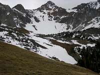
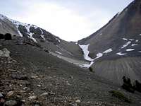
We had heard that the Lost River Range was already losing much of it's snow, but it was still shocking to see how little remained on the west and south slopes in mid May. The Super Gulley on Lost River had only a tiny ribbon of snow left and it was clear that the snow climbing season was pretty much over here. We wouldn't see much snow on our approach until near Leatherman Pass at 10,500. Still, there would be plenty of snow on the north and east sides of the peaks and snow in certain shaded gulleys would provide us with some challenging and interesting climbing.
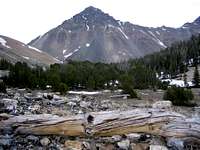
As we headed up the rugged Jeep road we saw remnants of a structure, perhaps a sawmill. At the first major switchback in the road, a trail starts out and stays just west of the Sawmill Gulch Creek, climbing steadily toward Sawmill Pass and a prominent flat area near the 10,000 foot level. This flat section was tree covered and would make excellent camping. Complete with a water source and top notched views of Leatherman, White Cap, and Bad Rock, there were definitive signs that any camping in this area most likely occurred here. Further past the flat area it became suddenly clear that we were now on a moraine steeply above and west of upper Lone Cedar Creek. The climbers trail now left the last of the trees and traversed across our first encountered snow fields, before reaching Leatherman Pass.
The relative shelter and warmth of the lower Sawmill Gulch was history as the wind howled in the 40 mph range at the Pass as we sought temporary shelter from the wind on the north side of the Pass. Adding to the shock and surprise at this typical high mountain weather was the fact that the last 2 weeks had been 80-90 degrees and sunny in the lower valleys. Today, it was clear that a major weather pattern shift was in the process and we were hoping that we would be able to get to the summit before this occurred.
We headed steeply up the west ridge and the wind became
tolerable as we negotiated in and out of the small rock towers that stud this
ridge. The first major challenge was a blocky rock slot and face that we
deemed low 4th Class for a move or 2 on top of extremely loose rock. The
further up the ridge we climbed, the steeper and less accessible the south side
of this ridge became and we donned the cramp-ons and ice ax for ascending the
snow chutes on the north side of the west ridge. The steps were easy for
kicking, but the snow lacked the depth needed for sustained climbing. The
result was loose rock interspersed with loose snow. My instincts
continually told me to check the dry south side of the ridge and I continued to
check this area only to find sheer drop offs. Finally, after some decent
snow climbing I found a notch on the west ridge that led to the snow-capped
summit. SuperDave continued up the north side snow chutes to reach the
summit.
The summit contained an impressive snow cap that was
visible from the lower valleys. Close up, the snow cap was really a wind
blown snow cornice that dropped off steeply on the south side and gently to rock
on the north side. Any summit register was buried, but visible was a rock cairn with a stick in it. We briefly took in the views, particularly
impressed with Bad Rock and
Mt. Corruption from that angle.
We decided to descend down the
We quickly headed down into the trees and