
-
 63253 Hits
-
 97.38% Score
-
 68 Votes
|
|
Mountain/Rock |
|---|---|
|
|
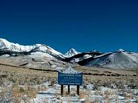
44.08200°N / 113.732°W |
|
|
Hiking, Mountaineering, Scrambling, Skiing |
|
|
Spring, Summer, Fall |
|
|
12228 ft / 3727 m |
|
|
Overview
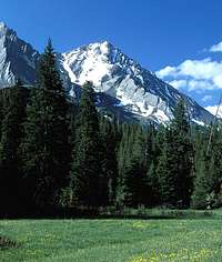
Leatherman Peak is located in the very rugged Lost River Range of eastern Idaho, and is the second tallest mountain in the state. It has one of the more easily recognizable summits in the range as it towers above the adjacent Leatherman Pass by over 1600 feet. The pass is pretty easy to spot since it’s the low point on the main Lost River crest. The peak was officially named in 1917 after Henry Leatherman, who hauled freight in the area during the late 1800’s. He is buried at Battleground Cemetery, which is located in the Big Lost River Valley, within view of the mountain. The peak was probably first climbed in 1914 by Thomas M. Bannon, who was a noteworthy USGS surveyor and an Idaho mountaineering pioneer.
The Lost Rivers are a fault block mountain range, with exposed layers of folded and twisted strata visible in many areas. A prime example of this condition can be seen on the southeast face of Leatherman Peak. An equally impressive showing of these rock layers is on display on appropriately named “Bad Rock Peak”. Bad Rock is the next peak southeast of Leatherman, and is very visible from Leatherman’s summit.
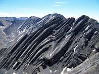 Bad Rock Peak Bad Rock Peak |
 Southest Face Southest Face |
 Bad Rock & Leatherman Bad Rock & Leatherman |
Due to the increasing number of people attempting to summit all nine of Idaho’s twelve thousand foot peaks, Leatherman has one of the busier summits in the state, especially in July and August. The peak could be considered one of the easiest, or one of the hardest Twelvers to climb, depending on which route is chosen. The easier of the two primary routes utilizes a steep gully on the west side of the north ridge. This is quickly becoming the standard route in spite of a very long approach road that must be taken in order to reach the trailhead on the west fork of the Pahsimeroi River. The alternate route that climbs the crumbling west ridge of the peak from Leatherman Pass is more challenging, but the starting point at the bottom of Sawmill Gulch is a much shorter and easier drive.
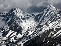
Panoramic Views
 The view from Leatherman Peak including Mount Corruption, Mount Church, and Badrock Peak. |
Getting There

Pahsimeroi Approach

Sawmill Gulch
Below are driving directions for reaching the two primary starting points for a climb of Leatherman Peak:
West Fork Pahsimeroi River
This area provides some of the best scenery to solitude ratios that you can find anywhere, and the grueling drive is definitely worth doing at least once in your lifetime just to see experience this awesome region. From Mackay Idaho, drive 23 miles northwest on Highway 93, then turn right (northeast) near Willow Creek on the road that leads to Doublesprings Pass. Continue for almost 11 miles, and then watch for a rough dirt road that heads east to Horseheaven Pass. Continue on this for about 14 more miles to reach the trailhead, steering right at a couple of intersections along the way. A high-clearance vehicle is required, 4WD is recommended.
Sawmill Gulch
The drive to Sawmill Gulch is much shorter and easier than the Pahsimeroi option, and does not necessarily require 4WD or a high-clearance vehicle (but you can sure shorten the approach hike if you do bring one). From Mackay Idaho, drive 13 miles northwest on Highway 93, then turn right (northeast) on the rough dirt road that heads toward Sawmill Gulch and Leatherman Pass. Those with low clearances vehicles will need to stop after around 1.5 miles, and begin hiking at about 7300’ elevation. Those with 4WD and already bad paint jobs can continue through a washed out section of road and go another mile and a half or so before parking.
Camping
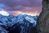
Leatherman Sunset
Highway 93 View
If approaching from the Pahsimeroi side, then camping is a very likely option. There’s a nice selection of tent spots at the trailhead, complete with a couple picnic tables and a primitive outhouse. You could also make your way up the trail a mile or two and set-up camp in spectacular upper Pahsimeroi Valley.
Options aren’t quite as abundant on the Sawmill Gulch side, but there are still a couple nice spots along the road near the upper trailhead (3 miles from the highway). Camping at Sawmill Pass would be a neat option as well, with a couple streams nearby, and fantastic views of Leatherman.
Red Tape
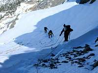
Snowclimb
No permits, parking passes, or any other kind or red tape to worry about. Just tread lightly and respect the local ecosystem.
When To Climb
Leatherman is most often climbed from mid June through mid September, but has seen ascents year round. Avalanches are a real danger in winter though. The north side of the peak is also a great option for a spring snow-climb and/or ski descent.
Mountain Conditions
Below are some good staring points for finding current conditions in the area:
- Salmon-Challis National Forest - NF Current Conditions.
- Lost River Ranger District - Contact Information.
- NOAA Pinpoint Forecast – Weather.
- Idaho Outdoors Forum – Message board monitored by many local climbers.
Guidebooks
The following two guidebooks contain detailed route descriptions for Leatherman Peak and other mountains in the vicinity:
 |
Idaho: A Climbing Guide by Tom Lopez – This is far and away the premier mountaineering text for the state, with a couple route suggestions for Leatherman Peak (but no details on the Pahsimeroi option at this time). |
 |
Trails of Eastern Idaho by Margaret Fuller and Jerry Painter – Detailed descriptions of hikes all over Easter Idaho including all the Twelvers, and details on both primary routes on Leatherman Peak. |
External Links