|
|
Route |
|---|---|
|
|
36.59080°N / 118.2878°W |
|
|
Scrambling |
|
|
Spring, Summer, Fall |
|
|
Most of a day |
|
|
Class 4 |
|
|
Overview
Like the North Ridge, the West Ridge of Mt Russell is accessed via the Tulainyo Lake basin. Tulainyo Lake is one of the crown jewels of the Sierra Nevada mountains, possibly the highest named lake in the continental U.S. The basin is flanked by Tunnabora Peak, The Cleaver, Mt Carillon, and the east and north ridges of Mt Russell. There are three possible approaches to the basin: via the Russell-Carillon Pass (13,280ft), via the Cleaver Col (12,960ft), and from the Wallace Lakes.The West Ridge is formed of serrated, knife edge towers composed of smooth glaciated granite. A true ridge-top traverse would involve multiple raps and a full complement of climbing equipment. Instead, the West Ridge route is a traverse of the north side that requires careful navigation of narrow ledges and occasional class 4 moves. The rock is excellent but the exposure is immense making it hard to argue this as a class 3 route (see Secor). By comparison, the East Ridge is a walk in the park (and an excellent descent route).
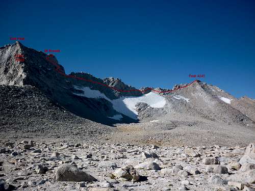 Approximate traverse route of the north side of the West Ridge shown (Sep 09)
Getting There
The route using the Russell-Carillon Pass is described in the East Ridge route page and involves a loss of about 500 feet.The route over Cleaver Col follows the North Fork trail to Lower Boy Scout Lake (LBL). At LBL, turn due north to follow Carillon Creek, bypassing the cliff face on the left. Once above this cliff, follow the creek to the cirque that is formed by Carillon, The Cleaver, and Pk 12910+. The col is up the cleft to the left of the low point notch. About half way up, the cleft steepens to Class 4 which can be bypassed by climbing the Class 3 chute to the left. The col is a short scramble up. Descend a couple of hundred feet to the lake and circle it to the north ridge.
The basin can also be approached from the John Muir Trail following Wallace Creek up to the Wallace Lakes. Some maps show the existence of a trail on the north side of the creek. From the upper lake, continue up the valley to the basin and the start of the ridge. Vacation Pass can also be used to access Wallace Lake using the bushwacking route up George Creek. However, this arduous approach is only open 15 December to 1 January and 15 April to 15 May due to Bighorn Sheep Zoological Area restrictions.