Introduction
My first trip to the Cascades was on Aug 7, 2006 with 2 cousins, Tola and Lucian. We typically do a trip together every year or two and had previously done trips in the Sierras, a paddling trip to the BWCA. We chose Glacier Peak for its remoteness, beauty and proximity to Tola’s new home. We also wanted to get some roped travel and glacial experience under our belts.
The Pacific Northwest is notoriously known to be damp and cold, anytime of the year. This is caused by warm Pacific air pushing against the Olympic and Cascades range, rising and meeting with colder air at higher altitudes. This weather system allows for a huge amount of snowfall in the winter, which last throughout the year at higher altitudes and therefore form glaciers. Statistically, the last 2 weeks of July and the first 2 weeks of August offer the best chance of dry weather in the Cascades.
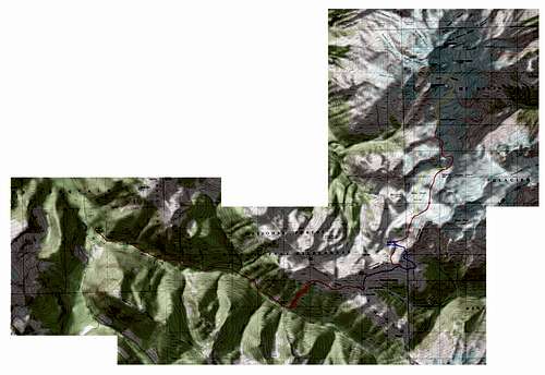
Route taken
Approach: North Fork Sauk River Trail #649 to White Pass to Climbers path around White Mtn to saddle between White River basin and Foam Creek basin.
Basecamp: Lake 6210, just north of the before mentioned saddle. In retrospect, Glacier Gap would make a fine base camp.
Climbing route: White Chuck Glacier to Suiattle to Gerdine to Cool with a little Disappointment Cleaver (south ridge) along the Gerdine.
Descent: same as approach.
![Glacier route]() Red is main, yellow and blue are descent variations, orange was planned
Red is main, yellow and blue are descent variations, orange was plannedTrip
Monday Aug 7th.
Tola picked up Lucian and I at the airport around 1:30PM. After stopping briefly for trail food and TP (thanks Gulf Station…) we headed north for Darrington and signed the Ranger register around 4:30, were at the trailhead at 5:00 and on trail by 5:30. Plan was to warm the legs up a bit, camp at the Mackinaw shelter and start our ascent on Tuesday the 8th. The old growth forest along the Sauk River is really impressive. To put it simply, everything along this path is just plane HUGE! The trees, the plants, the bugs and the horse dung. I hadn’t seen trees this large since the Sierras. After fording (actually rock hopping) Red Creek we setup camp half mile before Mackinaw, hydrated some food and hit the sack by 9PM.
Tuesday Aug 8th.
Up at 7AM. Coffee and oatmeal for bfast. Since this would be our first experience on a glacier, we though it prudent to touch up on self rescue and rope team skills, so Graham slung a rope 20ft. over a tree that has half fallen over the trail. We practiced self rescue and used some trees as pretend snow anchors to practice pulley systems. We are on our way after about 3 hours. Upon passing the Mackinaw shelter, we were glad to have not stayed there the night before. It’s a bit weathered to say the least… Half mile past the shelter and we hit the switchbacks. After switching 26 times, we ad gained 2200ft. and were on our way to White Pass. Saw a few golden eagles catching thermals on the way and as we gained altitude, the marmots began making our presence know to their buddies with cute marmot whistles. Took a breather at White Pass – ate some lunch – chatted with some PCT’ers and were passed by a stock caravan. After some rest, we headed NE on the obvious climbers path around White Mtn (this is a great trail by the way) and made it to our drop in point shortly thereafter. There are many ways to get up over the ridge and into the White Chuck basin. We chose to climb a dry runoff, the descended some pretty sketchy dry, loose scree. Atop the ridge, we caught our first glimpse of the mountain. What a huge chuck of rock!
![Glacier Peak and south route.]()
We took our time getting down and decided to make camp at what we thought was lake 6433, but turned out to be an unmapped lake 6210 created by White Chuck melting. We found a great little plateau, nice and soft. To this point, the weather had be absolutely beautiful, blue skis, little wind. However, as we were throwing tents, the fog started to roll in and within 45 minutes, we were engulfed in mist. Hit the sack around 9:30 with high hopes that it would clear.
Wednesday Aug 9th:
Woke up a few time throughout the night to clear skies and a beautiful and bright moon. Yes!! Our summit bid was on. Up at 3:00AM – fog, mist and clouds. Up at 5:00AM, same. We decided that we would hike up a bit and wait for the sun to rise with hopes that it would burn off the shitty cloud cover. Off at 6:00AM, to the White Chuck Glacier at 7:00AM, sat in wind and rain for 20 minutes and decided to head back to camp with no hopes the weather clearing. And it didn’t. Rained on and off throughout the day – took a 2 hour solo hike to scout the area and had a few glimpses of blue skis – hopes raised once again. The three of us crammed into Graham’s 1.5 person tent to cook, eat, tell stories and discuss a summit attempt for the next day. Bed by 9:00PM.
Thursday Aug 10th.
Up every at hour starting at 1:00AM. Clouds/rain, clouds, clouds, clouds, then at 5:00AM, a large clear patch just north of us right over the mountain! Graham roused Lucian and Tola who both had huge doubts about this clear patch holding. Tola decided to hold down the fort, while Lucian and Graham geared up for another attempt. Hot drinks and off by 5:45. Had a hell of a time navigating the old White Chuck glacier, it’s amazing how the terrain changes after 200ft. of solid ice melts away. After crossing a few remaining pieces of the White Chuck, we arrived Glacier Gap around 8:30AM. Roped up again, put on sunscreen, force fed, filled water and we were off with blue skies! On the Suiattle for a bit, then around to the Gerdine where we caught glimpse of Disappointment Peak and Glacier’s summit. A lenticular cloud was beginning to form at the summit, mares' tails were forming in the sky and fog was moving up the valley from the west.
![Glacier Lenticular]()
We both didn’t say much, just kept moving and tried to wish the weather away. We hopped onto the south ridge and climbed a bit, which allow us a better view of what was coming in from the west. Wind picked up significantly once atop the ridge and we stopped around 8000ft. to make a decision. Being that we were an inexperienced 2 man rope team, with no radio and only 1 bivy, we decided to bag it… A tough but wise one, as not even 45 minutes into out decent, the mountain was lost in grey clouds behind us.
![Glacier peak weather moving in]()
We descended quickly and it began to rain as soon as we hit base camp. Rested the legs for about 3 hours and we all decided to get off the mountain, not knowing how long the weather would last and not wanting to spend another day in our tents.. Packed up and headed out. Went over a saddle which brought us into the Foam Creak basin, skirted around pt. 6770 and back on the climber’s path. The descent was slow in the dark as it was very slippery and we were exhausted. 26 switchbacks and a 5 mile hike (which seemed like 10) and we made the car by 2:00AM on Friday the 11th. Lucian and I had later calculated 24.5 miles that day, with a lot of knee grinding vertical gain and loss... Back in the car, signed out at Darrington and in a nice warm bed at Tola’s house by 5AM.
Closing
Despite the weather, it was a great trip – learned a lot with no regrets. I’ll be back….


Comments
Post a Comment