Part 1: Getting to the trailhead
We were told by the Darrington ranger station that some cars were getting past the slump in the road 7 miles from the North Fork Sauk trailhead, but since we weren't sure if we could get there by car/truck, we brought along our mountain bikes.
When we arrived at the trailhead, there was a Ford Explorer behind us that decided that it would attempt to cross the slump. After watching them get through, we decided we could probably make it through in Charles' truck. Sure enough, we made it through and didn't have to break a sweat to reach the trailhead.
Part 2: Getting to camp
We planned on camping wherever we could find a decent spot near the White Chuck Glacier. To get there, we followed the North Fork Sauk trail to White Pass. There were several logs to clamber under or over along the way and continued along a well-trodden climber's trail until it seemed to peter out about a quarter or half mile before we reached the saddle at 6600'.
At about 5 miles (Red Creek?) there's a river crossing that was a little tricky, but a log crossing ~30 m downstream made things pretty straightforward.
The Mackinaw Shelter made a great lunch stop with easy access to the river. Time to shelter from trailhead: 2:40
At 4800', the trail cuts into an avalanche area with lots of downed trees. It's much easier to cut directly upslope at this point and skip a couple of switchbacks.
Around 5400' the blueberries were very good, so we stopped for 30 minutes to pick and consume.
The blueberries were good enough to attract bears - we saw one from White Pass; another party of 3 spotted two more west of the pass.
There were several places to fill up on water east of White Pass.
We found a great campsite next to a tarn at ~6700' at the base of a steep ridge with sandy places for tents. As the sun set, the clouds cleared enough that we could get our first glimpses of the White Chuck Glacier and the summit.
Total time to camp (including 30 minute lunch stop and 30 minutes of blueberry picking) - 8 hours
Part 3: Summit day
We awoke to some clouds but mostly clear skies. We left camp at 7:45 a.m. We knew that we had the option of ascending over Disappointment Peak or taking the less-direct route over the Cool Glacier. We opted for the Cool Glacier since we had brought our glacier gear and Disappointment Peak didn't look all that appealing.
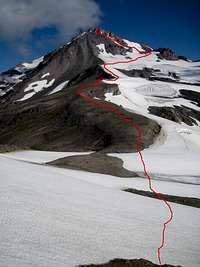
Note that on the USGS map for the area, the White Chuck Glacier is grossly overrepresented. It is approximately half the size it was when the map was updated. I've attempted to mark the melted area on our route map. This area is now filled with boulders, sand, and streams of varying size. There are also two new sizeable lakes.
On our way down from the ridge at 7500' we ran into a party of two which we had seen the previous morning. They needed to be back in Seattle for Monday and hadn't allowed enough time to get to the summit and back home, so they had to turn around early.
Shortly before we reached the Cool Glacier we ran into the party of two who we had seen Saturday morning in the Ford Explorer. They had already summited, since they had started at 2:30 a.m. They talked about possibly heading down to the trailhead that day. That sounded like a bit of a sufferfest to me (making Glacier Peak a 2-day trip).
We arrived at the west side of the Cool Glacier ~4 hours after our departure from camp. At this point we roped up, as the west side of the Cool Glacier was a bit broken up. We didn't have any problems finding a straightforward route for the 20m or so that it took to reach solid snow. We had to end-run a few crevasses but it wasn't long before we reached the ridge at 9640'. As the slope got steeper, there was some loose rock, but nothing too bad. We arrived at the summit at 1:25 p.m., about 5:40 after we left camp
After about an hour at the summit (I believe there were only about a dozen entries for the 2008 season), during which we talked to the party of 3, who also summited that day, we headed down via the Disappointment Peak route. We were very disappointed in the route that had been recommended by the party of 3. We found nothing but very very loose rock and sand and moved slowly to avoid burying each other under it.
As we reached the saddle before Disappointment Peak we watched two sailplanes (gliders) ride the thermals over the valley.
The other "interesting" part of the trip back to camp was the quicksand-like mud that we found about a half mile (or less) north of camp. Despite my best efforts to avoid it, I ended up with mud all the way to the top of my gaiters!
Altogether, our time back to camp from the summit was 4 hours.
Part 4: Return home
We awoke to almost perfectly clear skies but were chilled until we hit the south side of the saddle at 6600'. Our only problems during our descent were sore feet and sore knees, and we reached the trailhead at 2:20 p.m., 6:40 after we started (including 30 minutes for lunch).
The two most interesting things about the return trip were that 1) Charles had a business card from the Snohomish County Sheriff on his truck when we
returned, informing him that his driving on a closed road was a "criminal" offense and 2) a new road through the forest had been cleared to resolve the issue of the slump that had caused the closed road. We're waiting to find out what the cost of said criminal offense will be...


Comments
Post a Comment