What do Hoodoos?
What do Hoodoos?
Or
Goblin Valley Adventure Event
8-11-06 – 8-12-06
Ever since this event was announced, I have been looking forward to going. When it finally rolled around, my car was in the shop, so I already had a rental Pontiac Vibe.
Before we headed out (We being Hardy, Wendi, Randy and myself) we stopped at the store and picked up Steak, potato salad bacon eggs hash browns. We were gonna eat like Kings.
We got camp set up and Hardy set on blowing up his King size air mattress for them three. It was a good six inches thick. And took up ¾ of the tent. My mattress was measuring a good inch, an extra half inch if I was lucky, and was just big enough for me.
We realized we had forgot propane to cook food, so instead of asking someone to use their gas, we decided to eat sandwiches.We were one of the first to arrive and others started to trickle in.
There was a night time multi-cache and the winner got a topography program, an 80 topography program. The multi cache had 15 different waypoints and we were really looking forward to beating everybody at it. Until then, we socialized, bought some of the event coins. RabmlinRover brought some atl-atls and we spent a few hours with them. UtahJean even joined us for a while. Even though we were hitting the target, if things were up to us, we would be awfully hungry.
Nighttime finally came, and with the cloud cover, we were kinda disappointed the full moon may not show its face. We grabbed our flashlights and GPS’s and I grabbed my compass and we headed to the over look. The starting point of the multi-cache.
We ended up being the third team to get started, following DiViDe, a husband and wife team, and Cach-U-Nuts and his wife. Our start time was at 21:37 and we found the first waypoint no problem! It told us to go on a bearing of 115 degrees. We were looking for a reflector. We quickly found that. This waypoint had a question with two different answers, and two coordinates.
“Who discovered Goblin Valley?”
A. Mormons looking for water
B. Cowboys looking for lost cattle
I had read the pamphlet we received when we entered the park and read it. I even grabbed it and had it with me, just incase I would need it. I knew this answer was B, and entered the coords for the next waypoint, which was .64 miles away.
I double-checked the numbers, thinking that was kinda far for the game, but the numbers matched, and I shrugged it off, We wanted to win the topo program.
Hurrying among the hoodoos we ended up circling a large hill only to find the waypoint was pinging us on top of another even larger hill. We would follow drainages to find it would end in a 20-30 foot drop, and then we would backtrack and try another.
I finally went up one and found a way to the top, scrambling up the crumbly hillside. I did a quick scan, and could not find it, and headed back to where I could yell at the rest of the team to come and help me, I ran into DorkTeam6. We started looking together. (After all, there were two programs) We couldn’t find it. The coordinates put it in the middle of a bush, but it wasn’t there. We got the rest of our groups up to help us find it. After nearly 30 minutes of scouring the hilltop, other teams started showing up. We thought that maybe the container must have blown away.
We started back down, I was totally turned around. We found our way down a ravine and were at the valley floor where we were met up with RamblinRover, who was hosting this game. It turned out that he transposed some numbers, and was ½ mile off!
Laughing at he folly and RablinRover telling us he couldn’t figure out why we were so far out there. He found out by some other cachers that the numbers were wrong and he started gathering everybody up.
Walking back the moon appeared between the clouds. I hug back from the group and turned off my light. The moon shined a silvery light among the hoodoos.
Contrasts of light and shadow were amazing. It would be easy to get lost in the beauty of the moment and checking myself, knowing they would do a head count to make sure everybody had made it back, I hustled to meet with back with the group.
After the head count, others were starting the course again with the correct coords, and we went back to camp. It was late, and we were tired.
We woke in the morning and headed back to the valley. Randy and Wendi stayed at the overlook and participated in the kid’s activity with a Park ranger. They were talking about the wildlife in the park and going on a hike. Hardy and I went off across the valley to see if the cache in that area was easy enough to grab real quick.
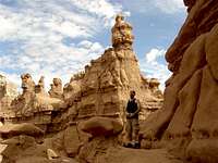
Traveling among the hoodoos was great! All shapes and sizes- some could be camels, some mushrooms, one with just a little bit of an imagination could see many different things.
In no time, we were at the other side of the valley. We scrambled up the sandstone cliff to see what was on the other side. There was nothing but desert. It was almost as if this wall of cliffs was protecting, or enslaving, these goblins from the rest of the world.
On our way back, we decided to pick up the multi-cache game we started last night. We were going along pretty good, but there was a question to an answer that I didn’t know (I didn’t have the pamphlet with me, I didn't think we would try to finish the game) so I headed back to the pavilion. Hardy stayed to finish, and I ran back to camp to see if Wendi and Randy had finished the activity and went back. They weren’t’ there, so I went back to finish the game, and they were coming back across the valley.
A potluck lunch was at eleven, so we headed back. A big spread of food was on the table and hot dogs were on the grill. When lunch was done, we had a drawing for door prizes.
Out of the four of us, Randy got the biggest prize of all. An Original Stash Geocoin. Wendi got a coin Quest II coin. We made out pretty good. (Hardy got a pin, and I got the makings for a micro cache)
A group of cachers were then headed for a cache called ‘Fat Man’s Misery”. We jumped at the chance to join them. Hunting for a cache with a group is always fun, and Others who have been there say it’s a classic.
We headed down the road and parked the car .19miles from the cache. We were looking for a crack to climb up. We found the crack and those who weren’t claustrophobic and small enough to fit, started up. It is obvious why it has its name. Shimmying in the crack, my boots were too big and had to ‘duck foot’ it through the crack. Others took a more perilous route and scrambled up a chute to the top. We found the cache quickly, and took some pics and headed back down.
Then we went to another cache- Temple Mountain Bear Den. It was only ½ mile away- Why not? Upon arriving there was an old settlement make of rocks from the area. It seems that it was an uranium mining operation there. We found the mine, but it had been sealed up. Hardy and Wendi realized they had visited this cache a year earlier and didn’t know they were so close to Goblin Valley. The abandoned ruins were neat, and after grabbing the cache, and taking some pictures of the houses and the formations, we headed back.
We hit a few caches on the way home, but speaking for myself, I was tired. It was hotter today than it was yesterday, (we had been very lucky, with the temps being in the 90/s) and the others fell asleep.
We hit a cache that was in a park. We were looking around a gun for the container when a older gentleman came over and told us what the gun was. He was a WWII veteran, and told us stories about his experiences in the war for over an hour! I really enjoyed the history lesson.
This trip didn’t give us many geocaches, but the scenery was great. Quality is better than Quantity. They say they want to do this every year. I hope so!


Comments
Post a Comment