
|
|
Canyon |
|---|---|
|
|
38.53800°N / 110.713°W |
|
|
Hiking, Bouldering, Scrambling |
|
|
Spring, Fall, Winter |
|
|
Overview
Note: Due to several email request pertaining to my Hiking with Children article, I have added Goblin Valley to Summitpost.Goblin Valley is a fantasy land of rock formations, ravines, little canyons, and rock towers. Children and adults alike will find much enjoyable exploring to do. This ranks as the best outdoor destination in the world for children, at least in my own opinion, and that of my three year old son.
Goblin Valley was visited by Native Americans hundreds of years ago, but it’s “rediscovery” happened rather recently. From the State Park Website:
Secluded Goblin Valley was first discovered by cowboys searching for cattle. Then, in the late 1920's, Arthur Chaffin, owner/operator of the Hite Ferry on the Colorado River, and two companions were searching for an alternate route between Green River and Cainsville. They came to a vantage point about a mile west of Goblin Valley and were awed by what they saw - five buttes and a valley of strange-shaped rock formations surrounded by a wall of eroded cliffs.
In 1949, Chaffin returned to the area he called Mushroom Valley. He spent several days exploring the mysterious valley and photographing its scores of intricately eroded goblins. Publicity attracted visitors to the valley despite its remoteness. In 1954, it was proposed that Goblin Valley be protected from vandalism. The state of Utah later acquired the property and established Goblin Valley State Reserve. It was officially designated a sate park on August 24, 1964.
If you are in the area, plan on at least a day to explore the area. There are many other sites to see in the area as well.
 One of the little goblins in the valley.
Getting There
Goblin Valley is located in Emery County between the towns of Green River and Hanksville, both in Utah. From Green River, travel west on I-70 for about twelve miles to exit 147 (Hanksville) and head south on Highway 24. After about 30 miles turn right at the Temple Mountain/Goblin Valley Junction. The junction has a sign. Drive west for about five miles and turn left. The paved road ends at the campground or valley overlook. Park at the overlook.Alternately, you can drive north on Highway 24 and then turning west (left) at the junction mentioned above.
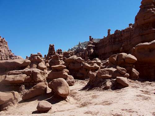
 Hiking in Goblin Valley
Routes Overview
Normally, I wouldn’t consider adding a Summitpost Page without route information, but this will be the exception. The reason is that in Goblin Valley, I feel it is much better to just set off and explore rather than have a certain destination in mind. There is an endless collection of hoodoos, rock walls, and small canyons to explore, and you don’t need a route description to explore the place.There are however, two specific trails I will mention. The Curtis Bench Trail is a marked route that connects the Campground and the main overlook. The Mollies Castle Overlook Trail, is a short trail from the main parking lot and overlook to an overlook of the Castle. Other than these two short trails, there are no marked routes, and you can just wander at your own will.
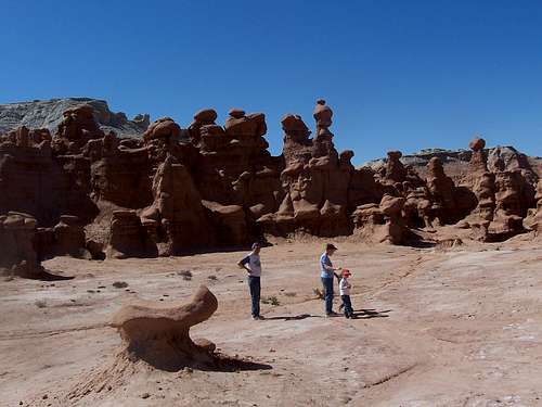
 There are many places to explore.
Rock Climbing
The rock here is not good for rock climbing, and I wouldn’t recommend trying any sort of rock climbing. Here is one thing interesting though. Once I heard one relatively well known climber claim that Wildhorse Butte, the towering butte in the northwest border of the valley as being unclimbed. How can this be? The topo map sows a benchmark up there. Certainly, the butte must not be unclimbed, but it looks extra loose and dangerous to me. I sure would like to hear the story behind the benchmark.In any case, in Goblin Valley, scrambling is a much better alternative to rock climbing. Some of the nearby towers is the San Rafael Swell do offer reasonable rock for climbing.
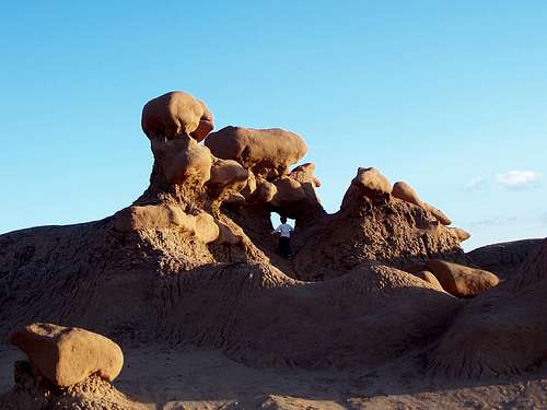
 Scrambling is a better alternative to technical climbing.
Red Tape
ATV's and mountain bikes are not allowed into the valley itself, but can be ridden or driven on th nearby roads.Day use fee is $6 per vehicle.
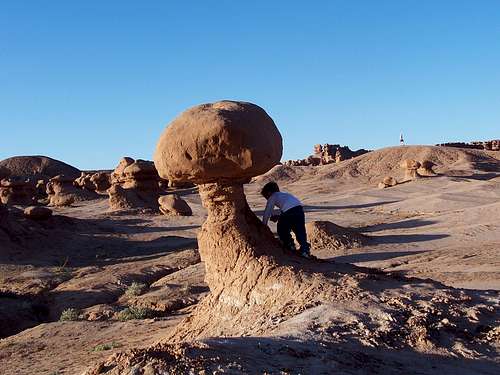
 We told Kessler this stone goblin comes alive after sunset, and gobbles up children, but he decided to take a closer look anyway.
Camping
Reserve the Campgound by either using the site below, or by calling Utah State Parks and Recreation at 800-322-3770, from 7:00 AM to 6:00 PM, Monday through Friday.Campground Reservations
Each campsite has a picnic table, paved parking pad, and barbecue grill.
The camping fee is $15 per night and includes drinking water, showers, and vault toilets.
 If you camp at the campground, you can stay long enough in the valley to see the sunset.
When to Go and Climate Discussion
Summer is extremely hot with temperatures exceeding 100F degrees (38C). Winter temperatures drop well below 0F (-18C). The best times of the year to visit Goblin Valley are March through mid-May and then again in late-September through November.This is a land of weather extremes. Temperatures in the nearest towns have ranged from -42F (-41C) to 112F (44.5C) at Green River and -35F (-37) to 114F (46C) at Hanksville. Sunny weather predominates and it only rains a few times a year, but when it does rain, it can really pour!
Weather and climate data for the Hanksville is below. *National Weather Service Data 1912-2004.
| MONTH | AVE HIGH | AVE LOW | REC HIGH | REC LOW | AVE PRECIP (in) |
| JAN | 39 | 9 | 69 | -35 | .33 |
| FEB | 49 | 19 | 74 | -33 | .21 |
| MAR | 60 | 27 | 88 | 4 | .42 |
| APR | 70 | 35 | 98 | 10 | .40 |
| MAY | 81 | 44 | 107 | 23 | .46 |
| JUN | 91 | 53 | 110 | 31 | .27 |
| JUL | 97 | 60 | 114 | 38 | .48 |
| AUG | 94 | 57 | 110 | 35 | .80 |
| SEP | 85 | 48 | 105 | 24 | .68 |
| OCT | 72 | 35 | 95 | -6 | .68 |
| NOV | 56 | 22 | 82 | -8 | .42 |
| DEC | 44 | 14 | 70 | -24 | .29 |
Dmitry Pruss - May 9, 2006 11:57 pm - Voted 10/10
Climb to the Goblin's RoostThe green-topped butte 5,108 due East of the parking lot is a relatively popular kids' climb (but quite a bit more strenuous than the usual goblin-hopping). A somewhat faint trail approaches SSE side of the butte. One has to either upclimb the right side of an oblong chokestone in a short class 4 chute, or go through a VERY DARK crack-cave some 100 ft East of the chokestone, climbing out by a series of ledges into a faintly lit crawlspace in the cave's ceiling. Also the coords are a few miles off, should be ca. 38° 33.86'N, 110° 42.14'W