
-
 17774 Hits
-
 84.82% Score
-
 19 Votes
|
|
Mountain/Rock |
|---|---|
|
|
34.36000°N / 117.88°W |
|
|
Sport Climbing |
|
|
Spring, Summer, Fall |
|
|
6500 ft / 1981 m |
|
|
Williamson Rock Closure
January 11, 2007: Here's the latest from Troy Mayr, guidebook author and founder of Friends of Williamson Rock:The U.S. Forest Service (USFS) is preparing a memorandum of understanding (MOU) between the USFS and FoWR. A memorandum of understanding (MOU) is a document describing a bilateral agreement between parties. It expresses a convergence of will between the parties, indicating an intended common line of action, rather than a legal commitment.
Friends of Williamson Rock (FoWR) will present the USFS a draft scoping letter pursuant to National Environmental Policy Act (NEPA). This letter will describe the proposed action regarding the preparation of an Environmental Assessment (EA) on the long-term management of Williamson Rock and the potential for reopening access to climbing activities. The following proposed alternatives shall be included:
•Dry Season Only Access (No flowing water in stream) - Preferred alternative includes monitoring and maintenance, enforcement of seasonal closure, signage, human waste management and parking controls.
•Restricted activity under limited conditions
•Permanent closure
•No project alternative - Return to conditions prior to closure (not a viable option)
The no project alternative is included in the document to serve as a baseline for other alternatives and is required of all NEPA documents. In the EA, the potential impacts for each alternative must be analyzed. The no project alternative states what the condition or environmental impacts would be in the event the proposed project is not carried out.
The scoping process will include an internal USFS review followed by a 30-day public scoping period.
As previously stated, the process is required to allow the potential re-opening of Williamson Rock, which has been closed to public access due to designation of critical habitat for the mountain yellow legged frog. Throughout the course of this lengthy NEPA and Endangered Species Act consultation ongoing closure of Williamson Rock should be anticipated and the climbing community should actively discourage its use to maintain current agency/FoWR relations.
FoWR expects this process to result in ongoing dialog with the USFS, U.S. Fish and Wildlife Service and the general public - resulting in a plan that meets the needs of all concerned within the parameters of NEPA, Forest Service Guidelines and the Federal Endangered Species Act. This will also further the intent of FoWR to move forward with the NEPA process and maintain cooperative relations with the U.S. Forest Service as well as the U.S. Fish and Wildlife Service.
We strongly encourage you to join the FoWR mailing list by visiting williamsonrock.org
Overview
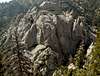
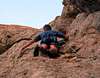
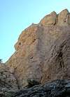
Williamson Rock is a sport crag located in the heart of the San Gabriel Mountains of Southern California. Climbs range in difficulty from 5.4 to 5.13. The number of easier routes is limited, however, so Williamson may not be the best place to take a beginner. Many of the routes are quite steep, and require good upper body strength and endurance. The rock is fractured granite that is surprisingly solid for the San Gabriels.Though some consider Williamson a choss pile, my personal experience has been that the rock is quite good, possibly due to others having already removed the majority of the loose handholds. The rock tends to be quite featured, with big holds on steep ground typical for the area.
The base of the rock is at about 6,300 feet elevation, which makes it a good place to escape the SoCal summer heat, though it can get plenty warm in midsummer. Most of the climbs face either south or east, making it possible to stay in the shade if you so desire. Little Rock Creek flows along the base most of the year. In early season the water may reach the base of the lowest climbs, making for a watery start, or requiring you to traverse in from drier ground.
I strongly encourage those who are interested in visiting the area to check out Troy Mayr and Anthony Sweeny’s guidebook (Southern California Sport Climbing WIlliamson Rock: Pocketguide, Mobius Publications, 1997. ISBN 0-9647462-1-2).
 |
Getting There
The area may be approached from either La Canada Flintridge or Wrightwood via the Angeles Crest Highway (SR2). It’s 40 miles from La Canada (about an hour’s drive), and a little over half that from Wrightwood. The rock is situated down in the canyon below the highway, with only the highest point reaching above eye level as seen from the road. Nevertheless, you can’t miss it. There are two parking areas more or less to the east of the rock. If approaching from La Canada, the first one is on the left (west) side of the road, and is marked. A steep, loose climbers trail descends north along a ridge into the canyon from the west end of the lot. Descending takes about 15-20 minutes, walking out is dependent on your conditioning and enthusiasm. The second parking lot is a couple hundred yards past the first (if coming from La Canada), and is also in the left-hand side of the road. From here a trail leads west, contouring along the north side of the canyon. This approach is considerably longer (about 40 minutes) though much less demanding, especially on the way out.
Route Overview
As of the publication of Mayr and Sweeney’s guidebook in 1997 there were over 250 established climbs at Williamson. An overview of the major formations is provided below. For detailed route information, buy the book. It’s only $10.95 at Sport Chalet in La Canada.The table below summarizes some of the main formations in the area, and lists some of the better climbs on each. Route information is provided in more or less detail, depending on the page author's familiarity with the route.
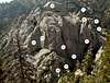
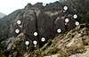
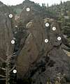
| Williamson Rock Climbing Formations | ||
|---|---|---|
| Formation | Routes | Description/Comments |
| Stream Wall | Quickie 5.8 Rock-it 5.7 Butterfingers 5.8 Scream Dream 5.10a Silvery Scream 5.10b Whose Line is it Anyway? 5.10d Created a Monster 5.10a/b Feast of Friends 5.9 Squeeze the Dream 5.9 Air Raid 5.9 | Located just around the corner from London Wall. In early season or wet years the base of the wall may be under water. Notes on routes: |
| London Wall | Had This Dream Stopped 5.11c/d Dream Speed 5.11a The Final Cut 5.12b/c Awkward Instant 5.12a Mythic Man 5.12a World on Fire 5.12b/c The Pursuit 5.12b/c Liquid Night 5.12c/d Furry Pump 5.12a Strange as Angels 5.11d The Labyrinth 5.11c/d KAOS 5.11b Peace Pipe 5.10c Totem Pole 5.10a | London Wall is about 50 yards downstream from where the access trail meets the stream. Depending on the water level, you may have to cross the stream several times, or clamber up and over obstacles on the east side of the stream in order to reach the wall. In early season or wet years the base of the wall may be under water. Notes on routes: |
| Voices Wall | Busy Signal 5.6 Voices Hotline 5.6 Is There Anybody Out There 5.6 Party Line 5.7 Bouncing Barnaby Bat's Baffled Bat Brigade 5.7 Alone 5.9 | Located just above (west) of the Mushroom Boulder. Fun, easy climbs with steel carabiners at the anchors. |
| Freezer Burn Wall | Irreparable Brain Damage 5.11a/b Impossible Concentration 5.11c/d Freezer Burn 5.11a Burnout 5.11c Faces and Names 5.11a Transcendental Escape 5.10b Freeze Frame 5.9 | Head up and left from the Voices Wall. Notes on routes: |
| Eagles Roost Buttress | Confirmed Insanity 5.11a Wicked Good Chode 5.10a/b Bumble Bee's and Moose Antlers 5.10c Being There 5.7 The Scenic Route 5.8 Bryophyte Balcony 5.10c The Saprophyte 5.10b Who Are You? 5.11b/c Written In Stone 5.11a Dancing in the Storm 5.10b F.S.T.D. 5.11c Belly of the Beast 5.11d H.B.R.W. 5.11c/5.10c Snap, Crackle, Take 5.11a | Continue up and left from Voices Wall to reach the base, which can be recognized by the huge chimney/gully heading up and right. Notes on routes: |
| Mushroom Boulder | Toadstool 5.11d Vicious Spore 5.13b/c Fungus 5.13b Trippin' 5.13a (TR) Shroomin' 5.11b Mushroom 5.8 Kill the Spore 5.11b/c Combucha 5.11a Organic Psychedelic 5.11a | Located just south of where the acces trail meets the stream. Notes on routes: |
| Sick Wall | Asgard 5.12b Pathetic Fallacy 5.12b Evil, Twisted, and Sick 5.12c G.B.H. 5.12c Sickness 5.13a Storm In Heaven 5.12a New Frontier 5.10c | Located high on the southwest portion of the rock. Continue up and left past Eagles Roost Buttress to a notch, climb over a boulder. Exposed slabs lead to Ego Buttress and Sick Wall. The Ego Buttress is on the left, Sick Wall on the right. Notes on routes: |
| Ego Buttress | Ego Maniac 5.10b Negative Ions 5.10b/c (TR) Anxious Mofo 5.10b/c Freudian Slip 5.11a Stone Blind 5.11a Placebo Effect 5.11a Shock Therapy 5.10d Key To Eternity 5.10a Provocative Redemption 5.10c Auf Wiedersehen 5.10c Killer Sun 5.10c Rubber Room 5.10a | Located high on the southwest portion of the rock. Continue up and left past Eagles Roost Buttress to a notch, climb over a boulder. Exposed slabs lead to Ego Buttress and Sick Wall. The Ego Buttress is on the left, Sick Wall on the right. Notes on routes: |
| Headwall/Leaning Pillar | Wedding March 5.7 One Move 5.7 Skeleton Approach 5.10c The Threshold 5.11c You Are Here 5.10c Finger Bang 5.11c Where Was I 5.10d Diamond Approach 5.10c Thrillseeker 5.12a/b Skeletons of Society 5.12d The Overlord 5.12d The Prime Directive 5.12b Solid Emptiness 5.11b/c | Notes on routes: |
| Waterfall Wall | The Invisible King 5.12a The Evil Twin 5.12c Carpe Diem 5.11d Wicked Chimney 5.8 (P1), 10c (P2) Timber 5.10c Industrial Disease 5.10c Valdez 5.10d Guilty Being White 5.11c Splish Splash 5.12d Stigmata 5.12b/c Short, Steep, Stupid 5.11c/d The Wicked Garden 5.12d The Secret Garden 5.12a | The obvious waterstained wall just upstream from the trail/stream intersection. Notes on routes: |
| Tombstones | Hang 'Em High 5.10d Twisted Cross 5.10c Ride the Lightening 5.11a Ice Queen 5.12a | Notes on routes: |
| Epitaph | Zappa Lives 5.8 Rest In Peace 5.10a She's An Addiction 5.10b | Notes on routes: |
| Ramblin' Wall | Ramblin' Man 5.10b Betty Boop 5.7 Child's Play 5.6 Ganactic 5.8 Grey Matter 5.10c Darkmotherscream 5.12b/c | Notes on routes: |
| Pyramid | Mischief 5.8 A Touch Of Evil 5.11b Bottled Violence 5.11c Downcast 5.11d Fire Walk With Me 5.12a/b Annuit Coeptus 5.11a The Third Eye 5.11b Sundog 5.8 Hopscotch 5.9 Park Avenue 5.8 Novus Ordo Seclorum 5.8 Golden Dawn 5.10b Take The Ant Track 5.4 | Notes on routes: |
| Blue Velvet Buttress | Lumberton 5.7 Joyride 5.7 Don't Look At Me! 5.10a/b Do It For Van Gogh 5.10b/c Here's To Ben 5.10c/d Hit Me 5.10b Now It's Dark 5.10c | Notes on routes: |
| Generation Wall | Second Generation 5.10b Generation Gap 5.9 Days Of Future Past 5.9 Our Children's Children 5.11c/d Meet The Shaman 5.12c/d The Shaman 5.11a Don't Squeeze The Shaman 5.12c/d Trigger Finger 5.12b/c The Hired Gun 5.10a Full Circle 5.10d Electric Sunshine 5.11b Wild At Heart 5.11c | Notes on routes: |
| Secret Garden Left | Secret Garden Variation 5.11c/d Garden Of Stone 5.10d Garden of Earthly Delights 5.11b Magic Garden 5.11b Gravity's Garden 5.11d New Creatures 5.12b/c Pretty Hate Machine 5.12a Terrible Lie 5.11c/d | Notes on routes: |
| Secret Garden Right | Up Above It 5.9 Down In It 5.10b Broken 5.10c Stormin' The Castle 5.10d Digging Your Own Grave 5.10d | Notes on routes: |
| Straights of Magellan | Captain Furious 5.10a The Flying Dutchman 5.11a The Southern Cross 5.11b Don't Feed The Plants 5.11c Captain Ned & the Raging Queen 5.8 Miles I've Come to Comfort You 5.9 | Notes on routes: |
| Spring Crag | Mount Up 5.11c Stripped Nut 5.10a Loose Nut 5.11a The Bandwagon 5.10b/c | Notes on routes: |
| | |  |  |
Red Tape
Williamson Rock lies in the heart of the Angeles National Forest. A National Forest Adventure Pass is required to park in the ANF. Annual passes are $30, and day passes are $5. Passes can be purchased an Forest Service offices and virtually any sporting goods store in Southern California.No permits are required for hiking or camping. Mayr and Sweeney mention some possible changes in trail access to Williamson in their 1997 edition. Although it’s not clear that anything actually happened, it’s best for climbers to treat this as a wilderness area in order to ensure continued climber access to the crag. Pack it out!
In dry years the Angeles National Forest is subject to fire closures. These closures may last well into the fall or even early winter, depending on when the first substantial rain occurs. If you’re not sure, check the ANF web site for the latest.
Angeles National Forest
701 North Santa Anita Ave.
Arcadia, CA 91006
When To Climb
March-October is the nominal climbing season, though snow conditions and/or your tolerance for cold may dictate otherwise. Even if you are game for a bit of January suffering, the road may not be open to the parking area if there has been recent snowfall.Camping
There are several campgrounds in the ANF, the nearest one being Buckhorn Flat, which is about three miles west of the parking lot on the Angeles Crest Highway. At the time this page was written, though, Buckhorn was closed due to bear activity. When it’s open, it offers 38 first-come, first-served camp sites. Two car, eight person maximum per site, $10 per night. Check the ANF’s web site for additional camping information, including phone numbers for current conditions and additional information.Guidelines for Route Pages
I'm just a lowly mountain page maintainer, with no real control over what people do in terms of route pages, but to help keep this set of pages reasonably well organized and easy to use I request that people wanting to add route pages kindly follow these guidelines:
- Please submit routes for named formations (such as those listed below), and not individual routes.
- When creating a route page, please include most, if not all, of the routes on the wall. I'm okay with not mentioning poor quality routes, but please include hard routes even if you don't think you'll ever be able to climb them. Someone else might find the information useful.
- Include at least one overview photo or your own original topo that illustrates where each route goes.
If you have suggestions on a better way to present route information please add a comment to this section.
Steve Larson - May 27, 2005 11:26 am - Hasn't voted
Untitled CommentI've added the warning. When did you discover the missing bolts? Are the anchors also gone?
darinchadwick - May 28, 2005 7:48 am - Voted 10/10
Untitled CommentI think it was around 2002, they might be replaced now. I used the anchors on top of Epitaph wall to descend. My guess is that Ganactic was the first route to the summit of Epitaph, and that the bolts were pulled out after they rap bolted the routes on Epitaph. Should ask Troy Mayr about that sometime.
Steve Larson - May 31, 2005 7:55 pm - Hasn't voted
Untitled CommentThanks. Next time I'm up there I'll check it out.
darinchadwick - May 27, 2005 9:09 am - Voted 10/10
Untitled CommentIn your route notes, could you please add that the bolts on the top half of Ganactic have been CHOPPED? You might save a life. It was one of the worst inadvertant free solos of my life. At one point I remember screaming 'I came out here to sport climb not to die!'. I wasn't proud, just scared s***less. Anyway, if you could include a warning for Ganatic on your route page to save other whimpy sport climbers (like myself) the excitement of unexpected free soloing....
thanks.
Steve Larson - May 27, 2005 11:26 am - Hasn't voted
Untitled CommentI've added the warning. When did you discover the missing bolts? Are the anchors also gone?
darinchadwick - May 28, 2005 7:48 am - Voted 10/10
Untitled CommentI think it was around 2002, they might be replaced now. I used the anchors on top of Epitaph wall to descend. My guess is that Ganactic was the first route to the summit of Epitaph, and that the bolts were pulled out after they rap bolted the routes on Epitaph. Should ask Troy Mayr about that sometime.
Steve Larson - May 31, 2005 7:55 pm - Hasn't voted
Untitled CommentThanks. Next time I'm up there I'll check it out.
MtnHiii - Mar 14, 2006 11:46 pm - Hasn't voted
Access Limited...The Angeles National Forest has closed the road prior to Williamson Rocks in an effort to keep climbers out of the area because they want to protect these endangered frogs that are apparently hanging out there. The area is not officially closed YET, but it may close soon. You can park up the road, its about a 1/2 mile to 1 mile walk along it to the trailheads mentioned in the descriptions here. A bike makes the trip fairly simple, and you can just chain it up somewhere at the top of the hill.
Steve Larson - Mar 15, 2006 6:47 am - Hasn't voted
Re: Access Limited...Ouch!!! I hadn't heard that. Does the FS have something on the web I can check out for details?
MtnHiii - May 10, 2006 1:16 am - Hasn't voted
Re: Access Limited...Sorry I havent responded for a while. Darren at Newcombs Ranch informed me that Cal-Trans controls the gate, not the Forest Service. They are, more or less, keeping it closed as a 'favor' to the forest service. If you contact them, they will tell you its closed. Cal-Trans apparently 'accidentally' keeps it open for long periods of times, particularly during the week. My advice would be to call Newcombs Ranch, ask for Darren, and see if he knows if its open. He is a freaking geyser of information. www.newcombsranch.com
Steve Larson - May 10, 2006 12:41 pm - Hasn't voted
Re: Access Limited...Sure, it's possible to get past the gate, but doing so would be an act of bad faith on the part of the climbing community, and might well have a negative impact on long-term access to the area.
MtnHiii - May 10, 2006 5:49 pm - Hasn't voted
Re: Access Limited...Heres the press release; interpret it as you will. Ultimately, though, contacting Newcombs Ranch has always provided a realistic opinion to the area I plan on visiting. If they REALLY dont care if you go there, Newcombs will let you know. ARCADIA, CA: December 23, 2005 In order to protect critical habitat of the mountain yellow-legged frog, the U.S. Forest Service will temporarily limit access to approximately 1,000 acres in the area north of the Angeles Crest Highway (SR 2) in the vicinity of Cooper Canyon beginning Tuesday, December 27, 2005. This includes Williamson Rock, an area frequented by rock climbers. At the request of the Angeles National Forest, the California Department of Transportation (Caltrans) will lock the gate at Cedar Springs (near milepost 62 on SR 2), east of the turn-off to Buckhorn Campground and west of the tunnels. Access to Eagles Roost Picnic Area will be walk-in only. This effort allows the U.S. Forest Service to follow the guidelines for protecting the habitat of the mountain yellow-legged frog, an endangered species. Specifically, a Biological Assessment will be undertaken to analyze the effects of human activities (including recreation) within the area which is proposed to be designated as critical habitat by the U.S. Fish and Wildlife Service per the Endangered Species Act. The Angeles Crest Highway, which is administered by Caltrans, has been closed to through traffic (connecting Wrightwood) since the fall of 2004, due to storm damage. By assisting the Forest Service with restricting use of the highway, an additional mile and a half of the road will be added to the normal seasonal closure. A portion of the Pacific Crest Trail lies within the impacted area. Hikers can take a detour around the area by departing the trail (northbound) at Eagles Roost and taking the highway to Cloudburst Summit, a distance of 4.5 miles. The U.S. Forest Service has also been meeting with members of the rock climbing community to work on a proposal that may allow climbing to eventually continue at Williamson Rock. “We look forward to working with these groups,” said Angeles National Forest Supervisor Jody Noiron. “Hopefully, we can arrive at a solution that can allow the recreational activities to continue while conserving the frog habitat. Both are part of our mission.” The Angeles National Forest is located northeast of Los Angeles. It is approximately 655,000 acres in size and includes the San Gabriel Mountains.