
|
|
Mountain/Rock |
|---|---|
|
|
36.32640°N / 75.38475°E |
|
|
Shimshal |
|
|
Mountaineering |
|
|
Summer |
|
|
19567 ft / 5964 m |
|
|
Overview
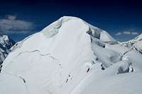 Summit of Yazghil Sar
Yazghil Sar is an isolated snow-and-ice peak between the Yukshin Garden and Yazghil glaciers in the Shimshal valley. It is a relatively easy to climb and ideal as a first Karakoram peak or as acclimatisation for higher/harder objectives. It is also easily accessible, located a days walk east of Shimshal village, which now has a Jeep road extending from the Karakoram Highway. The peak has two summits with the north summit being marginally lower than the main south summit.
The mountain takes its name from the grazing area on its lower slopes which is the nearest grazing area to Shimshal village. The peak may not be one of the Karakorum's most striking however the views from the mountain are stunning with particularly good views towards the northern faces of the Hispar Muztagh. North of Yazghil Sar the main ridge continues to Skirish Sar (6600m) before rising further to Yukshin Garden Sar (7000m). The summit ridge is relatively long and the main summit is often hard to identify until in close proximity. In 1988 Ernie McGlashan, Jack Brindle and John O'Reilly first reached the summit via the northwest face and north ridge. They made the climb in three days from base camp at 3600m on the lateral moraine next to the Yazghil glacier. A high camp was set on the northwest slopes at 4670m and a bivouac ledge hacked out of ice on the north ridge at 5180m. Since then the peak has received a steady flow of climbers including by a number of locals. The peak is a just under 6000m having been surveyed at both 5932m and 5964m. The Leomann map imaginatively surveys the peak at 6300m however the mountain is definitely not this high.
Getting There
Travel to the Northern Areas
Islamabad is the nearest international airport with flights arriving from around the world. Gilgit is the largest town in the Northern Areas served by regular transport from the north and south.
Domestic flights
PIA fly daily between Islamabad and Gilgit tickets can either be booked via their ticket offices or via their website. One-way fairs are currently Rs1590 with little discount for return trips. During bad weather planes may be grounded at short notice. Availablity is also a big problem. There are also daily flights to Skardu which operate a higher percentage of the time.
 Yazghil Sar viewed from the high camp at around 5100m Yazghil Sar viewed from the high camp at around 5100m |
 Yazghil Sar from the western side of the Yazghil Glacier Yazghil Sar from the western side of the Yazghil Glacier |
 Sunrise over Yazghil Sar's northern ridge Sunrise over Yazghil Sar's northern ridge |
Buses
Buses run daily between Rawalpindi's Pir Wadhai bus station and Gilgit, and vice versa. Buses leave throughout the afternoon and arrive mid-morning next day. Book tickets in advance if poosible to avoid a bone jarring, sleepless ride on the back seat. Travel along the KKH is anything but predictable and landslides, mudslides, rock fall and even avalanches can sever it for hours, days or weeks at a time. Due to Tribal tensions in the Kohistan buses were travelling in convoy for a significant stretch of the journey further lengthening an already long journey. NATCO and Masherbrum both run buses daily with a limited number of seats available at student discount.
The Northern Areas can also be reached from China with the trip from Kashgar to Sost taking 2 nights with an overnight stop in Tashkurgan. Hi-Ace vans ply the route between Sost and Gilgit throughout the day leaving as soon as they are full. There is now a direct bus between Tashkurgan and Gilgit, however, if travelling from China, it is better to buy a ticket to Sost only then take local transport to Gilgit as the international bus sits in the customs yard at Sost for a couple of hours while luggage is checked before continuing to Gilgit.
 Climb to high camp Climb to high camp |
 View od summit from Base Camp View od summit from Base Camp |
 Yazghil Sar's summit Yazghil Sar's summit |
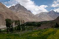
Reaching Shimshal
The Jeep track to Shimshal was completed a couple of years ago and it is now possible to travel from Passu on the KKH in a couple of hours. There is a daily public Jeep although this does not seem to run at a regular time and I have often had to hire a private Jeep or wait a day. Passu-Shimshal special hires cost around Rs2500. All vehicles leave from the Shimshal restaurant which is a short distance north of the Batura Inn. Until last year vehicles left from the cluster of buildings in the centre of Shimshal however this is no longer the case.
 Torpupdan (6106m) Torpupdan (6106m) |
 Jeep track to Shimshal from Passu Jeep track to Shimshal from Passu |
 Jeep track to Shimshal Jeep track to Shimshal |
 Water Crossing Water Crossing |
 Malanguti Glacier Malanguti Glacier |
Reaching the Mountain from Shimshal
 Ablation valley before the Yazghil glacier
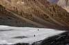
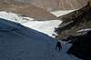
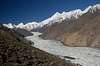
Porters are easy to arrange in Shimshal. We paid three stages to climb to a shepherd hut at 3500m. Four stages is asked for to go to base camp at around 4500m. Unlike to rest of Pakistan Shimshalis only carry 20kg (opposed to 25kg) plus there own equipment. They ask for Rs300 a stage including food allowance. Shimshali porters are hard working and generally reliable however. The way to Yazghil Sar follows the Shimshal valley east following a faint trail along the southern edge. It takes the best part of a day to reach the Yazghil glacier and cross it. Prior to crossing the Yazghil Glacier the trail follows an attractive ablation valley. The Yazghil Glacier is beautifully white unlike most in Pakistan which are covered in moraine. Route finding across the glacier is not straight forward but local porters know the way and there should be no problems in their company. Having descended to the western edge of the glacier walk a short distance south to where the glacier is flatter, then cross. Crevasses are less of a problem on the glacier however much of the glacier is too steep to traverse. There is no water between Shimshal and Yazghil Glacier however clear water is in abundance on the glacier. Bring sufficient water from Shimshal village. On reaching the eastern edge of the glacier again walk a short distance south to where a path climbs from the glacier to a camping spot (3300m) when running water. The paths leading from the glaciers on both east and west banks are hard to spot. From the east side of Yazghil glacier the route I took is described on the northwest face and north ridge page. Skirting the Yazghil glacier to the north is not really worthwhile due to the significant detour. The glacier also extends to the Shimshal river making a detour difficult anyway.
 Crossing the Yazghil Glacier Crossing the Yazghil Glacier |
 Crossing the Yazghil Glacier Crossing the Yazghil Glacier |
 Crossing the Yazghil Glacier Crossing the Yazghil Glacier |
Continuing to Base Camps to the East of Yazghil Sar
If attempting to climb to mountain from the east, having crossed the Yazghil Glacier, continue along the southern aspect of the main valley then head south to Baruchit Gaz (marked on the Swiss map) to the north-east of Yazghil Sar and at the northern tip of the Yukshin Garden Glacier. I am not sure what water sources are at Baruchit so check in Shimshal before leaving. Although I did not climb the north-eastern ridge there looked to be a straight-forward ascent line to the main north ridge that leads to the summit. A more direct route up the ice flow to the south of the NE ridge did not however look feasible due to broken crevasses blocking an approach.
 Climb to camp at 3500m on Yazghil Sar Climb to camp at 3500m on Yazghil Sar |
 Climb to base camp at around 4500m Climb to base camp at around 4500m |
Climbing Conditions
For many people visiting Pakistan's Northern Areas for the first time the warm summer's take time to adjust to. In Gilgit time temperatures regularly stay in their 30s during the summer and whilst it is cooler in the mountains it can still be uncomfortable at times. On days where there are no clouds a single layer will surfice and measures need to be taken to prevent sun burn. Weather can change quickly with fresh snow falling at any time in the year or heavy rains at lower altitudes. Come prepared for a range of climates.Nights are generally warmer during the climbing season compared to destinations such as the Pamir, Tien Shan or Napalese Himalaya and an early start when climbing is usually imperative to avoid soft snow in the afternoon.
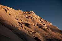
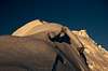
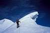
 Approaching the Summit
Ascent Photos
 Crossing snowfield Crossing snowfield |
 Approaching the snow line Approaching the snow line |
 Climbing the NW Face Climbing the NW Face |
 Climbing gully on the NW face Climbing gully on the NW face |
 Climbing the NW Face Climbing the NW Face |
 Climbing the NW Face Climbing the NW Face |
 Just below high camp (5100m) Just below high camp (5100m) |
 Sunrise over N Ridge Sunrise over N Ridge |
 Cornice on N Ridge Cornice on N Ridge |
 View of Summit (l) View of Summit (l) |
 Summit! Summit! |
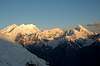
Views of the Hispar Muztagh and surrounding peaks from Yazghil Sar
 Yazghil Glacier Yazghil Glacier |
 View south from summit View south from summit |
 Peaks above Yukshin Gardan Glacier Peaks above Yukshin Gardan Glacier |
 Khurdopin Glacier Khurdopin Glacier |
 Karan Koh and surrounding peaks Karan Koh and surrounding peaks |
 Distigil Sar (7885m) & Shimshal Whitehorn (6303m) Distigil Sar (7885m) & Shimshal Whitehorn (6303m) |
 Peaks above Yukshin Gardan Glacier Peaks above Yukshin Gardan Glacier |
 Virzharav Glacier Virzharav Glacier |
 Sunrise from Yazghil Sar's northern ridge (high peak is Karan Koh) Sunrise from Yazghil Sar's northern ridge (high peak is Karan Koh) |
 The Yazghil Domes The Yazghil Domes |
 Peaks above Yukshin Gardan Glacier Peaks above Yukshin Gardan Glacier |
Red Tape
Permits
No permit is required to climb the mountain as it is under 6500m (see table below). The peak is not in a restricted area and no permit is required to visit Shimshal. Consequently there is no need to be accompanied by a guide unless so desired. A liaison officer is also not required. For higher peaks in the Gilgit region the following royalties must be paid although no liaison officer is currently required.
| Elevation | Normal Fee | Fee for 2009 | ||
| Expedition royalty | Additional royalty per person | Expedition royalty | Additional royalty per person | |
| 7501 - 8000m | $400 | $50 | ||
| 7001 - 7500m | $250 | $40 | ||
| 6501 - 7000m | $140 | $20 | ||
| Up to 6500m | No fee | No fee | ||
Royalties per expedition are based on a party of 7. Persons additional to this number will be subject to an additional royalty fee.
Visas
A valid visa is required. Visas are NOT issued at the airport and must be obtained prior to arrival. Some embassies such as those in Central Asia are reluctant to issue visas and advise you to obtain them from your home country. A single-entry tourist visa is valid for 3 months from the date of arrival in pakistan and for 6 months from the date of issue. Some visas are only valid for 3 months from the date of issue so check if necessary when applying. Visa prices vary. Americans pay the most for their visa whilst Japanese get theirs free! Visa extensions and reentry stamps used to almost impossible to obtain however the process has become remarkably easier in the last few years. Gilgit DC is a good place to try.
Camping and Accomodation in Shimshal
Descriptions of campsites are included in the 'getting there' section and on the Northwest face and Northern ridge page. Camp at 3500m Camp at 3500m |
 Yazghil Sar base camp Yazghil Sar base camp |
 Camp at 5100m Camp at 5100m |
Camping Fuel
Kerosene is widely available in bazaars and can often be found in smallers villages. Pakistani kerosene burns sootily so be prepared to clean your multi-fuel stove regularly. White gas is not available and denatured alcohol is available only in Rawalpindi and Islamabad.
Gas stove cannisters are sold in the outdoor shops on Gilgit's main high street. They are often refilled so don't expect the usual butane/propane mix. They are generally available in sufficient number for a medium sized expedition.
Food Provision
There is no need to bring food supplies from your home country as sufficient provisions can be found in Gilgit. Grocer shops sell staples such as pasta, dal, rice and porridge. Fresh fruit is of poor quality in Gilgit and likely to turn to mush in your rucksack before even reaching base camp. Dried apricots and mulberries and readily available and make for a good snack.
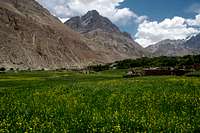
Accomodation in Shimshal
Accommodation in Pakistan is extremely cheap costing as little as a dollar for a bed in some hotels. There are currently two places to stay in Shimshal. I have always stayed at the Sifat guesthouse, which is located just south of the newly built school on the northern edge of the village. The guesthouse is run by a friendly man by the name of Ferman who prepares good food and is very helpful with respect to arranging porters for guests. He also has good knowledge about the area. The second accommodation option is a newly built small hotel (and still being built as of June 2006) also near to the school. It is run by a Shimshali who has previously climbed Nanga Parbat. I have not stayed at the hotel however I have met the owner who has an excellent knowledge of the mountains in the local area.
 Shimshal village Shimshal village |
 Shimshal village Shimshal village |
 Shimshal village Shimshal village |
Maps
The best maps of Pakistan are the 1:50,000 and 1:100,000 Russian maps. They are not cheap however and I would not say they are a requirement for climbing this peak. A more readily available map is the orographical map produced by the Swiss Foundation for Alpine Research. The scale is only 1:250,000 however I have found it serves its purpose for general route finding and is particularly good for identifying peaks (although not all the surrounding peak heights in the area have been properly surveyed). An AMS map also covers the area of Shimshal (NJ 43-15) however it is inaccurate and few peak heights have been surveyed. Yazghil Sar is surveyed as being 17,820ft. The Leomann orographical map (1:200,000) is the most readily available map for but is also particularly useless and also wildly over-estimates the height of Yazghil Sar (6300m).External Links
Matthieu Paley has produced an excellent brochure on Shimshal for Pakistan's Ministry of Tourism. It is available online here.There are also some excellent photos of Pakistan's Northern Areas on Matthieu's own website here.