
|
|
Mountain/Rock |
|---|---|
|
|
37.25910°N / 111.92344°W |
|
|
Hiking, Mountaineering, Trad Climbing, Toprope, Bouldering, Scrambling |
|
|
Spring, Fall |
|
|
5524 ft / 1684 m |
|
|
Overview
Simply put, Yellow Rock is a more of a hill rather than a true mountain, but what a beautiful summit it is. Of all the summits in the world I have climbed, Yellow Rock ranks as the most colorful of all. Unfortunately, our photos don’t do it justice.Yellow Rock is located in the Escalante-Grand Staircase National Monument which was established in 1996. It used to be a seldom visited summit, but its fame is becoming more widespread so there a few hikers and climbers out and about. The entire region is a fantastic wonderland of colors, desert, forest, canyons and peaks.
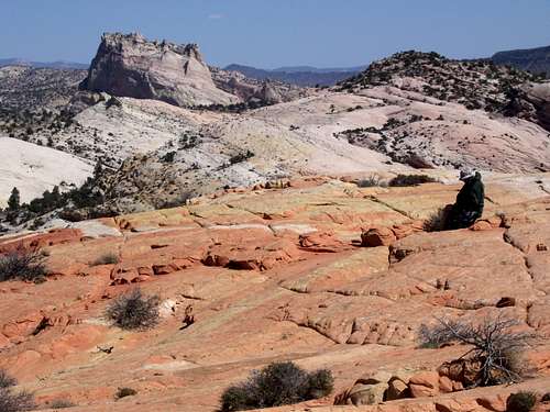 Looking north from the summit of Yellow Rock.
Getting There
You can access the Yellow Rock trailhead from the north or the south, but either route involves the Cottonwood Wash Road. In dry conditions, roads are good for all vehicles.From the north, drive Highway 12 from Cannonville (between Bryce Canyon National Park and Escalante) south then east along the paved road to Kodachrome Basin State Park. After 7.3 miles, there is a junction with the left fork heading for Kodachrome Basin. Instead of turning north to the state park, continue along the Cottonwood Wash Road (mostly unpaved but in good condition). Drive another 24.6 miles (use a map) to the trailhead at the mouth of Hackberry Canyon.
From the south, drive Highway 89 between Kanab and Page to the Cottonwood Wash Road between mile markers 17 and 18. Follow the Cottonwood Wash Road for 14.6 miles to the trailhead at the mouth of Hackberry Canyon.
 Yellow Rock from not far from the trailhead.
Routes Overview
There are several routes available, but the East Slopes Route is best. We took a route farther north going up, but it was steep loose and scary. The East Slopes route is quite easy and only a rough class 2. Much of the East Slopes Route is along colorful slickrock.
Red Tape
Tread lightly. For a Nation Monument, Grand Staircase-Escalante is rather hassle free, but see the information below:Grand Staircase-Escalante National Monument
 There are red rocks, but not so much red tape.
Camping
There are good campsites at the trailhead and in several locations nearby.When to Go
Mid March through May and mid September through mid-November are best. Winters are usually sunny and this can be a good time to climb, but the Cottonwood Wash Road can be slick and muddy after a fresh snow (or rain). Summers are hot, but early mornings can be pleasant. Summit area of Yellow Rock in April.
Mountain Conditions
CLICK HERE FOR YELLOW ROCK WEATHER FORECASTBelow is the National Weather Service Climate Summary of Kodachrome Basin, not far north of Yellow Rock. The data is from 1979-2007. Temperatures should be fairly similar, but perhaps a bit warmer at Yellow Rock.
| MONTH | AVE HIGH | AVE LOW | REC HIGH | REC LOW | AVE PREC (in) |
| JAN | 45 | 16 | 68 | -16 | 1.13 |
| FEB | 49 | 21 | 75 | -25 | 1.26 |
| MAR | 57 | 26 | 81 | 5 | 1.09 |
| APR | 66 | 31 | 88 | 12 | 0.74 |
| MAY | 75 | 38 | 97 | 15 | 0.61 |
| JUN | 86 | 45 | 100 | 27 | 0.37 |
| JUL | 91 | 53 | 104 | 36 | 1.02 |
| AUG | 88 | 52 | 101 | 31 | 1.65 |
| SEP | 81 | 43 | 95 | 24 | 1.35 |
| OCT | 69 | 33 | 90 | 10 | 1.28 |
| NOV | 54 | 23 | 76 | 2 | 0.72 |
| DEC | 46 | 16 | 67 | -17 | 0.70 |