
|
|
Area/Range |
|---|---|
|
|
37.77000°N / 111.601°W |
|
|
Hiking, Mountaineering, Trad Climbing, Sport Climbing, Toprope, Bouldering, Aid Climbing, Big Wall, Mixed, Scrambling, Via Ferrata, Canyoneering |
|
|
Spring, Summer, Fall, Winter |
|
|
Overview
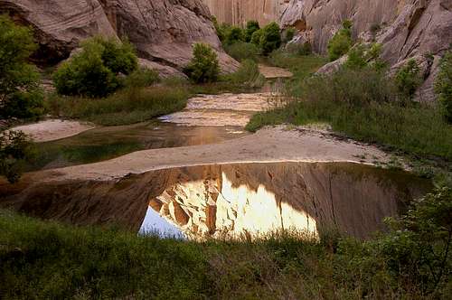
The Grand Staircase-Escalante National Monument is one of my favorite areas to explore. It is located in southern Utah and is managed by the Bureau of Land Management (BLM). It is a vast area (1.9 million acres) bounded by the Arizona state line to the south, Lake Powell to the east, and the Dixie National Forest to the west and north. One can spend a lifetime exploring this fascinating area!
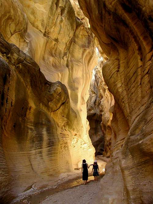
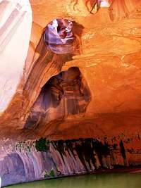
As the name suggests, there are two main facets to the monument. The Grand Staircase is a series of uplifted colorful sandstone cliffs that decrease in age but increase in height as you go north. The Paria River cuts through this portion of the monument. The southern portion of this river cuts through a long dramatic and narrow canyon. Buckskin Gulch is a tributary of the Paria River and it is famous for being the longest slot canyon in the world.
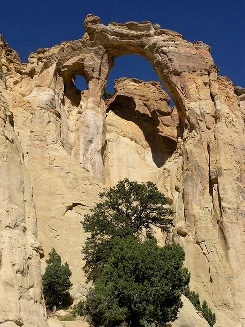
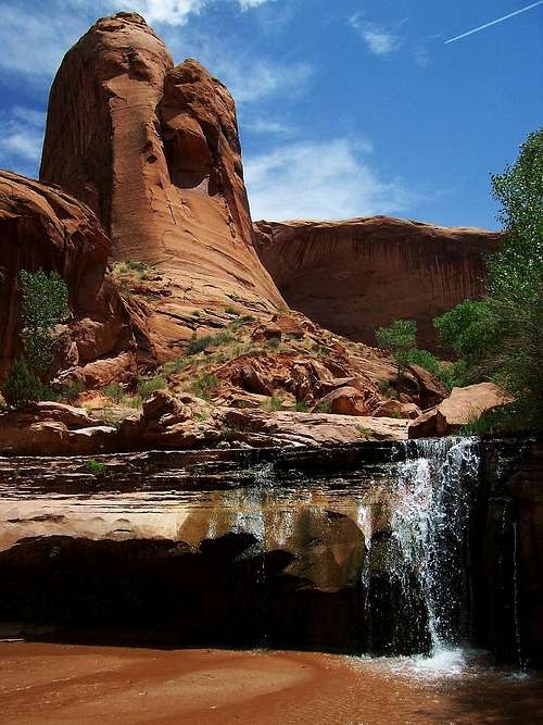
The Escalante portion of the monument is to the east and here the Escalante River and its tributaries cut through layers of brightly hued sandstone on its way to the Colorado River. Here there are dramatic rock formations including natural arches and bridges, beautiful waterfalls such as Upper and Lower Calf Creek Falls, and countless other wonderful sights to see.
Some would say there's a third major portion to the monument and that's the Kaiparowits Plateau. It is sandwiched between the Grand Staircase and the canyons of the Escalante. Here the sights are varied and include brightly hued cliffs, pinyon pine and juniper covered mesas, and natural sandstone arches.
Link to the current Grand Staircase-Escalante National Monument Visitor Guide
Getting There
Here is a good map of the Grand Staircase-Escalante National Monument. An interactive map of the area can be found on the BLM website.
Hwy 89 cuts across the southern part of the monument.
Bryce Canyon National Park abuts the western edge of the monument.
Hwy 12 is a Scenic Byway and All-American Road and it runs along its northern boundary.
The eastern boundary is formed by Capitol Reef National Park and the Glen Canyon National Recreation area (Lake Powell) along the Colorado River.
Major roads running through the monument include the Cottonwood Road, Hole-in-the-Rock Road, Burr Trail, Skutumpah Road, and Smoky Mountain Road.
Red Tape
Overnight permits are required within the Monument for all overnight car camping or backpacking. Permits are free of charge and may be obtained at any monument visitor center (listed below) or at developed trailheads.
Driving off of designated roads is prohibited within the Grand Staircase-Escalante National Monument.
Monument Visitor Centers
Kanab Visitor Center
Address: 745 E. Highway 89
Kanab, UT, 84741
Phone: 435-644-4680
Summer Hours: 8:00 AM - 5:00 PM
7 days a week
mid-March - mid-November
Winter Hours: 8:00 AM - 4:30 PM
Monday - Friday
mid-November - mid-March
Escalante Interagency Visitor Center
Address: 755 W. Main
Escalante, UT, 84726
Phone: 435-826-5499
Summer Hours: 7:30 AM - 5:30 PM
7 days a week
mid-March - mid-November
Winter Hours: 8:00 AM - 4:30 PM
Monday - Friday
mid-November - mid-March
Cannonville Visitor Center
Address: 10 Center St.
Cannonville, UT, 84718
Phone: 435-826-5640
Summer Hours: 8:00 AM - 4:30 PM
7 days a week
mid-March - mid-November
Winter Hours: Closed
mid-November - mid-March
Big Water Visitor Center
Address: 100 Upper Revolution Way
Big Water, UT, 84741
Phone: 435-675-3200
Summer Hours: 8:00 AM - 5:00 PM
7 days a week
mid-March - mid-November
Winter Hours: Closed
mid-November - mid-March
Anasazi State Park Museum
Address: 460 N. Highway 12
Boulder, UT, 84716
Phone: 435-335-7382
Summer Hours: 9:00 AM - 5:00 PM
7 days a week
mid-March - mid-November
Winter Hours: Closed
mid-November - mid-March
Paria Contact Station
Address: Highway 89 (44 miles east of Kanab, UT)
Phone: Not Available
Summer Hours: 8:30 AM - 4:15 PM
7 days a week
mid-March - mid-November
Winter Hours: Closed
mid-November - mid-March
Camping
There are a few developed campgrounds in and near the monument.
Calf Creek Campground is located along Highway 12 between Escalante and Boulder, has 13 sites and is also the trail head for Lower Calf Creek Falls. The fee is $7 per night or $2 for day use.
Deer Creek Campground has 4 sites and is located 6 miles east of Boulder along the Burr Trail.
Whitehouse Campground has 5 walk-in tent sites and is located about 43 miles east of Kanab off of Hwy 89 near Paria Canyon. There is no water or trash service and the fee is $5 per night.
Kodachrome Basin State Park Campground is located along the Cottonwood Road south of Henrieville and Cannonville. This campground is one of my favorites. The state park has lots of beautiful trails and hot showers to boot! Click here to find out more info.
Escalante State Park near Escalante has a campground. Click here to find out more info.
You can also disperse camp in most areas of the monument. Most areas do not have any facilities so be prepared to pack out what you pack in, bring your own water, and please practice Leave No Trace ethics.
Weather and Safety

National Weather Service Local Forecasts
A complete list of good safety information can be found here. Here are some of the finer points...
Obtain Maps & Current Information
Hiking here is generally on unmarked routes. Obtain current hiking information and topographic maps prior to your trip. When possible, stay on established routes. Let someone at home know your plans and when you expect to be back.
Know Who to Contact in an Emergency
Keep in mind that cell phones do not work in many parts of the Monument, so don’t count on them. Bring a signal mirror as a backup communication device.
Drink Plenty of Water
Drink a minimum of 1 gallon of water per person per day. Filter or treat all water.
Know Where You Are
Hiking in the Escalante River canyons requires walking in water and beating a path through thick vegetation. Side canyons are easily missed. Stay oriented to your location by using a topographic map.
Beware of Hypothermia
Many canyons have deep pools that require wading or swimming. Wet conditions may cause hypothermia even during hot weather. Carry dry clothing.
Quicksand is common in the Monument
Although few pockets are more than waist-deep (most are less than knee-deep), it’s best to avoid it. If you do step in quicksand, don’t panic!
Be Prepared for Poor Road Conditions
Storms can leave dirt roads impassable for several days. Leave extra food and water in your vehicle.
Flash Floods
Flash floods can occur at any time of year, but they are most common in July, August, and September. Checking the local weather forecast is advisable, but you should realize that conditions change quickly, and it is impossible to predict where heavy rain will occur. Avoid narrow canyons and washes during stormy weather. Be aware of changing weather conditions. Know your escape routes. If you’re hiking in a stream, be aware of rising water levels or stronger currents and sudden changes in water clarity. Educate yourself on the terrain you are entering. Realize that dry washes are a result of previous flash floods.
By entering a narrow canyon or wash, you are assuming a risk.
If flooding begins, seek high ground and wait for the water to go down before attempting to walk out. Do not enter a narrow canyon if storms threaten. Never camp in a wash bottom.
Creepy Crawlies and Other Things
Educating yourself about the hazards associated with snakes, insects, and poisonous plants in the desert is essential.
Deer flies and gnats come out in the early summer months. In wet areas, wear long pants and long sleeve shirts to avoid fly bites.
Poison ivy grows here near water sources. Know how to identify it — remember, “leaves of three, let it be.”
Geology, Flora, and Fauna

The Grand Staircase-Escalante National Monument is a geologic treasure! Find out more here... The Geology of Grand Staircase-Escalante National Monument
There is a wide diversity of plants and animals in the monument. Click on these links to find out more! Flora and Fauna
Proclamation
Grand Staircase-Escalante National Monument was created by presidential proclamation September 18, 1996. Click here to read the proclamation.
External Links
Grand Staircase-Escalante National Monument Website
Glen Canyon Conservancy
Dixie National Forest
Capitol Reef National Park
Glen Canyon National Recreation Area
Bryce Canyon National Park
Paria Canyon/Vermillion Cliffs Wilderness Area
Box-Death Hollow Wilderness Area
Everett Ruess
"I thought that there were two rules in life - never count the cost, and never do anything unless you can do it wholeheartedly. Now is the time to live." ~ Everett Ruess
Everett Ruess was an irrepressible wanderer, adventurer, and artist who loved and sought out the wild places of the Colorado Plateau. In 1934, at the age of twenty, he disappeared in the Escalante canyons. His independent spirit and profound love of the beauty of canyon country has inspired me and many others to continue to explore and preserve this wonderful area.
In his chapter entitled Episodes and Visions in Desert Solitaire, Edward Abbey mused on Everett Ruess:
"Even after years of intimate contact and search this quality of strangeness in the desert remains undiminished. Transparent and intangible as sunlight, yet always and everywhere present, it lures a man on and on, from the red-walled canyons to the smoke- blue ranges beyond, in a futile but fascinating quest for the great, unimaginable treasure which the desert seems to promise. Once caught by this golden lure you become a prospector for life, condemned, doomed, exalted. One begins to understand why Everett Reuss kept going deeper and deeper into the canyon country, until one day he lost the thread of the labyrinth; why the oldtime prospectors, when they did find the common sort of gold, gambled, drank and whored it away as quickly as possible and returned to the burnt hills and the search. The search for what? They could not have said; neither can I; and would have muttered something about silver, gold, copper -anything as a pretext. And how could they hope to find this treasure which has no name and has never been seen? Hard to say -and yet, when they found it, they could not fail to recognize it. Ask Everett Ruess."
Link to more information about Everett Ruess