
|
|
Mountain/Rock |
|---|---|
|
|
47.09826°N / 13.08643°E |
|
|
Hiking |
|
|
Summer |
|
|
8081 ft / 2463 m |
|
|
Overview
The Zittrauer Tisch, located in the lower Goldberg Group between Stubnerkogel and Silberpfennig, rising south of the Angertal valley and north of the Nassfeld valley, is a two-summited mountain (the lower summit (2409m) being referred to as Tischkogel; it’s here, not on the highest point, that the summit cross was put up) that is one of the clearly shaped and dominating peaks of the central Gastein valley. It’s fairly easy to get up to, even though steadiness, non-fear of heights and adequate mountain shoes and clothing are required, and offers very beautiful views upon the Gastein valley, the Hochkönig, the Tennengebirge, the Ankogel Group, the Glockner Group and especially the high peaks of the Goldberg Group. The name « Zittrauer – or Zitterauer – Tisch » (« Tisch » being the German word for « table ») was derived from the family name of the possessors and heirs of an alpine estate named Zitteraugut, or « Zitterau estate », that dates back to the year 1613, if not even earlier.The quickest way to get to the summit is to take the Stubnerkogelbahn cable-car from Badgastein to the summit of the Stubnerkogel (2246m) and follow the path descending to the Zittrauer Scharte (also named Jungerscharte, 2163m) and leading fairly steeply up the grassy slope to the Tischkogel and along the summit ridge to the Zittrauer Tisch (duration: 1 hour). But there are many other possibilities of access to the summit and of combining it with longer hikes – see « routes ».
 Hoher Sonnblick seen from the Zittrauer Tisch
 Looking beyond the Gastein valley to the Hochkönig from the summit
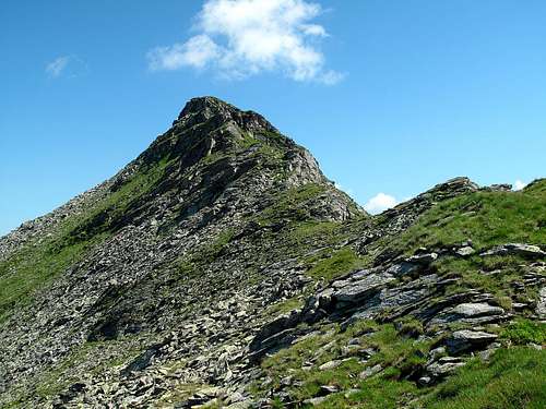
Getting There
The starting point is in any case Badgastein.Nearest airports are: Munich, Salzburg, Klagenfurt.
By car from Munich via Salzburg: Take the motorway to Salzburg, then change to the A10 motorway in the direction of Villach-Klagenfurt, exit at Bischofshofen, take the B311 federal road following the signs to Zell am See-Innsbruck, exit at Lend (after Schwarzach), following the signs to Villach/Gasteinertal, and continue past Dorfgastein and Bad Hofgastein until Badgastein. Distance Salzburg-Badgastein: 94 km, duration: 1h 17min. Distance Munich-Badgastein: 225 km, duration: 2h 29min.
By car from Klagenfurt: Take the motorway to Villach (this is also the place to head for at first if you're coming from Italy), then turn onto the motorway in the direction of Salzburg - Munich (Tauernautobahn). Follow it until Bischofshofen, then as above. Distance Klagenfurt-Badgastein: 220,6 km, duration: 2h 36min.
Another possibility, coming from Klagenfurt, would be: Follow the Villach-Salzburg-Munich motorway as far as Spittal an der Drau, exit here, follow the signs to Lienz, exit at Lurnfeld, follow the signs to Obervellach, turn right in Obervellach, head for Mallnitz and drive to the railway station. Here you can have your car loaded onto the train that goes through the Tauerntunnel to Böckstein. From Böckstein it's only 5 km until Badgastein. Distance Klagenfurt-Mallnitz-Badgastein: 130,3 km, duration: 2h or more, depending on road conditions and frequency of the Tauerntunnel trains.
By train: If you're coming from Munich or from Vienna, take a train to Salzburg first, and then change to one of the trains that commute between Salzburg and Villach/Klagenfurt. All fast and international trains on this line (there's one every two hours) stop in Badgastein.
If you're coming from Klagenfurt, take one of the fast trains bound for Salzburg and alight in Badgastein.
From Italy or Slovenia: Take a train to Villach, change here to the train bound for Salzburg and alight in Badgastein.
Routes
Going up from Badgastein: Follow the well sign-posted path up the wide and evenly rising slope of the Stubnerkogel to it’s top (duration: 3,5 hours) and then follow the path indicated above. An interesting variation would be: Turn left at the middle station of the Stubnerkogel cable-car, go to the Obere Zittrauer Alm (or Hochalm) and follow the fairly steep path leading straight up to the Tischkogel (2409m). From here, head for the Zittrauer Tisch’s highest point (2463m) following the summit ridge. View from the Zittrauer Tisch's summit
 View to the Salzburg-Carinthian mountains from the way up to the Zittrauer Tisch
Going up from Nassfeld-Sportgastein: Follow the path up to the Lower Bockhartsee lake on 1872 meters (an artificial lake), cross the dam, and follow path no. 110 up to the Miesbichlscharte pass on 2237 meters (Sportgastein-Miesbichlscharte: 2,5 hours). On the other side, shortly below the pass, turn right and follow path no. 111 in north eastern direction to Ortbergscharte col (2273m). Apart from crossing a block field, the path is easy. From Ortbergscharte on, continue following the path straight to the main summit of the Zittrauer Tisch. The path gets steeper in this section; watch out for exposed bits just before reaching the summit. As long as it’s dry, there is no problem, in wet weather the rocks can be slippery. Miesbichlscharte-Zittrauer Tisch: ca. 1 hour 15 minutes. As to scenery, this is the most rewarding path of ascent – naturally well preserved and great views to the Goldberg and Glockner peaks as well as to Hochkönig and Tennengebirge behind the Gastein valley!
 View from the path between the summit and the Ortbergscharte
One hike I can strongly recommend is: Start at the top of Stubnerkogel (cable-car from Badgastein), follow the described paths over the two summits of the Zittrauer Tisch and down to Miesbichlscharte (this route is also known as the Otto-Reichert-Weg). Cross the Miesbichlscharte, turn right shortly below and follow path no. 111 (from this point on it’s named H.-von-Zimburg-Weg) in western direction to the Upper Bockhartsee lake (a beautiful spot upon 2076 meters), and rise 150 meters to the Bockhartscharte pass on 2226 meters (from here goes the normal path of ascent to the summit of the Silberpfennig, 2600m). From here, descend in approximately two hours past the gorgeously situated Filzenalm pasture to Kolm Saigurn at the very end of the long Rauris valley and at the foot of the Hoher Sonnblick (3105m). Total duration of this route (Stubnerkogel-Zittrauer Tisch- Miesbichlscharte-Oberer Bockhartsee-Bockhartscharte-Filzenalm-Kolm-Saigurn): approximately 6 hours.
 Looking over the Miesbichlscharte to the Geisselkopf-Schareck chain