

-
 49315 Hits
-
 97.08% Score
-
 65 Votes
|
|
Area/Range |
|---|---|
|
|
32.65°S / 70°W |
|
|
Hiking, Mountaineering |
|
|
22841 ft / 6962 m |
|
|
Introduction
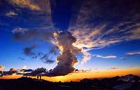
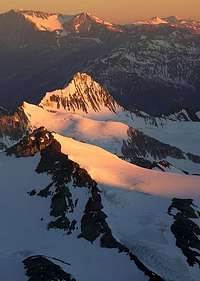
Sunset and climbers at Nido
Aconcagua, the highest mountain outside Asia as well as the highest on the American continents is located in the mid-west of Argentina. It's surrounded by a lot of interesting peaks and the national park they're located in attracts about 10 000 climbers and hikers every year. All the peaks belongs to the longest mountain range in the world - Los Andes. This particular part of the range is called The High Andes.
As the park (read Aconcagua) attracts a huge amount of people every year there's a permit fee and strict park regulations to follow.
There is something of interest for all kind of nature and mountain lovers in this park. Hikers go their for easy day treks and world class climbers can find their Eldorado on some of Aconcagua's south face which offers a lot of routes of high difficulty.
Aconcagua is also one of the very popular Seven Summits (the highest peak on each continent) and as the normal route to its summit is very straight forward climb, it's a feasible target even for a well trained weekend adventurer.
Most climbers going to the area have their minds 100% set on the Big One, but there are many other peaks which offers interesting climbing. Some are used as acclimatization peaks, some as separate targets. The nature in the park is stunning and it's well worth a visit even for non-climbers.
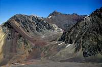
Aconcagua National Park
Close to the entrance of the park
For all other mountains in Argentina a very simple rule applies: Pick a peak, go there and climb it. This is not the case with the peaks within the borders of the Aconcagua National Park. First of all you need a permit, which can be bought in the permit office in central Mendoza, the capital of the province with the same name.
More info on this:
- The excellent Aconcagua page on Summitpost
- The official web site.
When you have your permit you can either go straight for the park and attempt the peak all on your own or, more commonly, contact an organizer who'll arrange all the details, such as transport, mulas, base camp support etc.
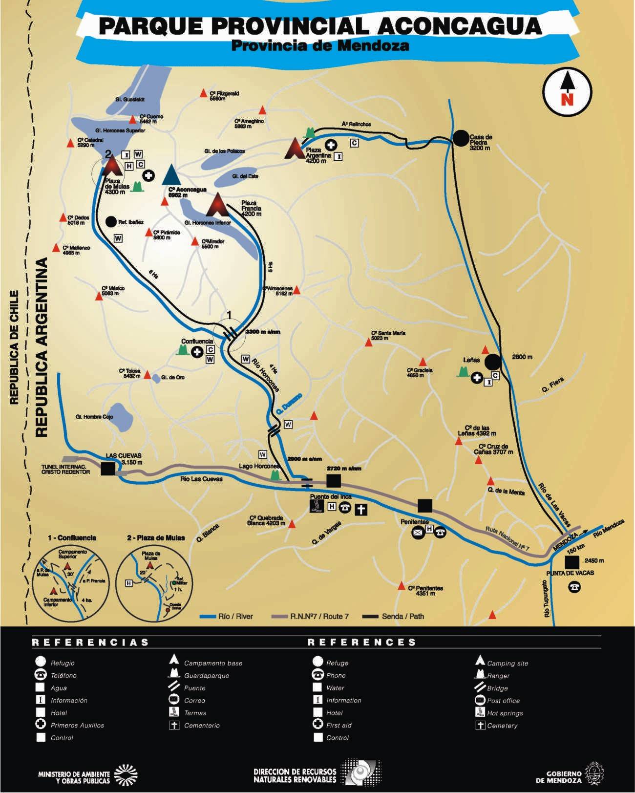
There are two main valleys in the park and a huge majority use these to reach the foot of Aconcagua. The Horcones Valley on the western side of the peak takes you, via Confluencia to Plaza de Mulas and the normal route. The Vacas valley on the eastern side of mountain takes you to Plaza Argentina, which is the base camp for "The Polish Glacier side" of Aconcagua.
See map.
The normal climbing and trekking season is from December to mid March.
A lot more information about this can be found on Aconcagua page.Camping
![Bonete and the other...]()
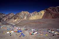
Plaza de Mulas
The camping is restricted in the park. You're obligued to stay in the official camp spots along the way to the peaks.
On the walk in - Horcones Valley/Normal Route:- Confluencia. A large camp 1-3 hours from the park entrance. It's huge and usually there are a loads of people around. Large mess tents, sleeping domes and restaurants. The water is said to be a bit too rich in magnesium and some people experience light stomach problems from drinking it.
- Plaza de Mulas. The base camp. A large area with anything you want (and don't want) can be found here. Internet, restaurants, a techno tent (!), places to rent anything from guides to gloves and porters and tents. A restaurant and hotel is located about 15 min away. The park rangers has a hq here and there's also a little clinic.
If you for some reason is unable to reach any of the camps, the rangers of the park usually allows you to camp in between. A valid reason, such us altitude sickness or a sore ankle is usually accepted, but some zealots have told climbers to rent a mule to go down or up to the next camp.
Higher up on Aconcagua you can basically camp anywhere, but if you're in a large group you may be told to use the official camp spots.
![Brad Marshall]()
Independencia refugio - Camp Canada. At 5050m is a wind swept place with quite limited space. Water can be a problem here. An alternative camp is to be found a bit S of Canada proper.
- Camp Alaska at 5370m is a spread out place and tents are scattered over a large area. Most climbers gives this place a miss as it can be tricky to find a flat spot.
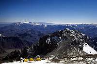
- Nido de Condores. 5500m. A large good camp, which usually have either running water, or lots of snow to melt. The park ranger's last outpost. The place from which about 40% of the climbers attack Aconcagua's summit.
- Berlin. 6000m. Three small refugios in various condition offer a place to sleep if you for some reason don't want to use your tent. Many complains about too much junk and excrements around this camp.
- Colèra. A bit over 6000m. Located off the main trail to the N. In a better and cleaner location than Berlin, but a bit hard to find for those who don't know the area.
- Ameghino ridge. 6250m. Not an official camp spot, but used quite often. Can be very windy, but offers a short way to the summit and fantastic views to the north.
- Independencia at almost 6400m is an old wrecked refugio, which in itself offers little more than an emergency place to sleep. High and cold.
![Ameghino seen from roughly...]()
Ameghino ridge campThe weather
![Storm]()
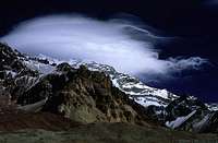
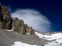
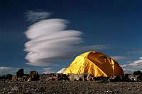
A storm rolling inAconcagua is the highest peak in the area and therefore it attracts bad weather. If there's only one single cloud on the sky, it's a fair chance it's hanging over the summit of Aconcagua. Weather changes are swift and sometimes very dramatic. A clear day can transform into a windy and cloudy hell in a matter of an hour. The most feared and infamous condition is the Viento Blanco (white wind).![El viento blanco. The flat...]()
Viento Blanco clouds - Usually the forewarning comes in the shape of an ominous looking cloud formation over the highest peaks. It looks like a soft cotton cap, which is constantly shifting in shape. When you see it - beware! A storm with very fast temperature plunges and ferosious winds are usually around the corner. If the storm breaks, heavy snow usually follows. The really rough storms usually arrive from the west.
That said, the area can also be warm and nice and the weather systems usually holds for some time. When it's warm, don't be surprised you don't have use for many of the cold weather items you brought. I have seen summiteers in only wind proof fleece jackets and without gloves.
Another common weather type is the clear day, with fresh and chilly air and high winds. In general this type of weather is good for climbing, as it's a solid and not so quick changing weather pattern. Be prepared for cold climbing though.The surroundings
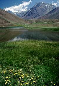
When leaving Mendoza you're traveling from the hot flat lands of Argentina, into the dry mountains of Los Andes. An almost desert area is passed and the little town of Uspallata is the last oasis with some real vegetation in terms of trees. The gorge leading to the national park and later the Chilean border has steep mountain sides with very little greenery. At the entrance of the park there are still some grass, but after only a couple of hours walking you can't spot a sign of flora. It may sound like a dull landscape, but the colors of the surrounding peaks well makes up for the lack of trees, flowers and plants.
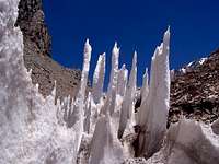
The sights of mountain sides in red, gold and sometimes almost green makes the walk in a beautiful experience. When getting close to the base camp, (Plaza de Mulas) the landscape shift quickly to a more alpine experience.Penitentes fields, small melt-off rivers, glaciers and snow capped peaks appear all around you. The valley terminates at the Cuerno-Horcones wall of peaks with large glaciers.![Penitentes in the way to C1....]()
Penitentes
Rock climbers don't have much of a treat here, as the rock in general is quite rotten.The mountains in the group
Only some very basic information about every peak, plus some route information will be given on this page. To get the full story, please continue to the mountain's individual pages.
If nothing else is pointed out, the access to the respective peak is via Horcones Valley/"Plaza de Mulas side"/Normal route.
![6:30 am January 1, 2006....]()
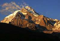
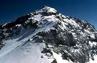
Aconcagua
Aconcagua - 6962m
The highest peak in the group and by far the most popular. A goal for all kinds of mountaineers from all over the world.
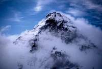
![A view of Ameghino from camp...]()
Ameghino
Ameghino - 5918m
The second highest mountain in the park and for many years thought to be over 6000m. An easy climb and good acclimatization peak from Plaza Argentina.
Access from Aconcagua's east side/"Polish Glacier side"/Vacas Valley.![The color of Manso makes it...]()
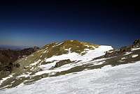
Manso
Manso - 5434m
According to the legend about area, one of the "shoulders" of Aconcagua. A common acclimatization target from Plaza de Mulas or a day hike for excellent views from Nido de Condores.
![Bonete is the peak in the...]()
Bonete
Bonete - 5004m
The peak can be seen and easily reached from Plaza de Mulas. An easy climb with great views to the next valley.
![Cuerno from Camp Canada after...]()
Cuerno
Cuerno - 5400m
Cuerno means "The Horn" and it's looming over Plaza de Mulas. It's rarely climbed as it's not an easy walk up as many of the other peaks close by.
![La Mano, seen from the Polish...]()
La Mano
La Mano - 5300m
Located a long day's walk north of the park and extremely rarely climbed. Its high technical difficulty and hard access makes this beautiful peak a great trophy for any climber.![Cerro Rico from the summit of...]()
Rico
Rico - 5400m
Located on the east side of Aconcagua and clearly seen from Plaza Argentina. An easy climb which makes the peak the best first acclimatization target on this side of the central massif.
Access from Aconcagua's east side/"Polish Glacier side"/Vacas Valley.![Cerro Catedral]()
Cerro Catedral
Cerro Catdral - 5254m
Located on the west side of Aconcagua and is clearly seen from Plaza de Mulas. It's an easy day's climb from Plaza de Mulas and is the main contender to Bonete to be the best acclimatization climb before heading for Aconcagua.![Ibañez]()
Ibañez
Ibañez - 4800m
Another one of Aconcagua's shoulders. Located close to Aconcagua's massive south face. A dangerous climb from Plaza Argentina and very technical from Plaza Francia.
Access from Aconcagua's east side/"Polish Glacier side"/Vacas Valley.![Interesting evening light]()
Cruz de Caña
Cruz de Caña - 3686m
A small trekking peak with access from Penitentes.Mountains not yet on Summitpost
![Piramidal]()
Piramidal
Piramidal - 5700m
A side peak of Aconcagua. It can easiest be reached from the Horcones valley via a narrow river valley. It's a technical climb and it's said there are Inca relics close to the summit.![De Los Dedos]()
De Los Dedos
De Los Dedos - 4900m
When you walk the long and dry stretch in the Horcones valley you see a peak in the end of it. That's De Los Dedos. The easiest access to it's summit is from the ENE side.- Mirador - 5511m
- Tolosa - 5300m
- Mexico - 5000m
- Matienzo - 4901m
- Pan de Azucar - 5100m
- De Los Horcones - 5383m
- Almacenes - 5271m
There are more mountains in the outskirts of the group.Place names on this page
There are a lot of names on this page and it may be a bit confusing. I also added some more which you may see on other pages related to the area.![Tent and Cloud]()
Lenticular cloud at Nido
Random order. S, N, W and E are used to indicate where the places are located in reference to Aconcagua. - Plaza de Mulas - The normal route's base camp. W side.
- Plaza Argentina - The base camp on the E side.
- Plaza Francia - The camp below the south face. SE side.
- Paso Ibanez or Paso Rico - The pass in between Plaza Francia and Plaza Argentina.
- Horcones Valley - The valley which leads to Plaza de Mulas and the normal route. W and S.
- Vacas Valley - The valley which takes you to Plaza Argentina and the E side of Aconcagua.
- Nido de Condores - A camp spot on approx. 5500m on the normal route. NW.
- Camp Berlin - A camp and refugio on the normal route. 6000m. NW.
- Camp Colèra - A camp a little bit of the normal route on 6000m. NW.
- Camp Canada - usually the first camp on the normal route at about 5000m. W.
- Confluencia - The first large camp in the Horcones Valley. SW.
- Polish Glacier - The name of the glacier on the E side. See routes for more info. E.
- Puente del Inca - The starting point for the normal route in the lower end of Horcones Valley. SSE.
- Punta de Vacas - The starting point for the eastern routes, leading to Vacas Valley. S and E.
- Los Penitentes - A little cluster of buildings on the main road. Hostels and mule services here. S.
- Las Lenas - Camp spot in the Vacas Valley. ESE.
- Casa de Piedras - Camp further up the Vacas Valley. SE.
- Guardaparque - The name for the park rangers in Spanish.
- Independencia - A destroyed refugio on the normal route at 6350m. NW.
Maps
The best I've found is from Meridies.
More maps and guidebook info on: Andes - Guide Books & Maps Page.
![Meridies Maps - Aconcagua & Torres del Paine]()
Aconcagua + Torres del Paine
![Meridies Maps - Aconcagua & Cordon del Plata]()
Aconcagua + Cordon del PlataRemarks
- If you want to have editing rights for this page and have photos to contribute with, please drop me a note.
- The altitudes given on this page may not be the same as those on the mountain pages for the respective peaks. I have used the elevations given on the latest map for the area.


