

-
 27816 Hits
-
 82.48% Score
-
 15 Votes
|
|
Route |
|---|---|
|
|
44.57450°N / 6.14340°E |
|
|
Mountaineering, Trad Climbing |
|
|
Summer |
|
|
A long day |
|
|
4a |
|
|
Class 4 |
|
|
8 |
|
|
IV |
|
|
Overview
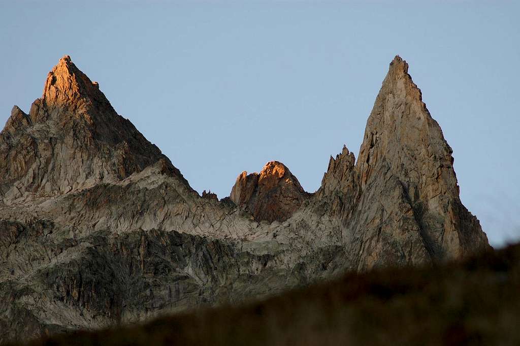
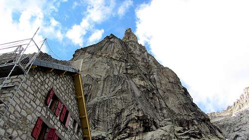
Aiguille Dibona is a breathtaking summit, undoubtedly one of the most coveted peaks of the French Alps and one of the finest spires worldwide. Whatever is the route you have chosen, the climb on Aiguille Dibona is always a wonderful adventure, giving impressive views and unique sensations on perfect rock. Plenty of difficult climbing routes run on the walls of this perfect arrow.
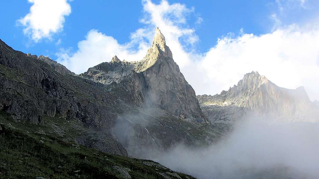
Actually the Dibona is a granit blade placed side by side to the Aiguilles du Soreiller, and its spectacular profile seen from the hut path is a bit misleading: from the side the slender decreases and the back is it has a more massive and less impressive shape. Formerly known as Pain de Sucre du Soreiller, the spire was renamed in honour of the great alpine guide Angelo Dibona, who realized the first ascent of the peak with Guido Mayer on 27 June 1913, denying its fame of inaccessibility. At the foot of the mountain is the Refuge du Soreiller, accessible in 2h30m from the village of Étages.
Usually, to climb the Normal route of Aiguille Dibona you walk for 1h around the west face, to end up climbing a 50m ridge on the north side.
However there is a good alternative to that walk, by climbing on the east side along la Voie du Nain, then end up on the last 50m of the normal route. I highly recommend this route as it gives more climb and less annoying hike.
Getting There
The closest village is Les Etages, a little hamlet located 3 km before La Bérarde in high Veneon, a valley of Oisans Massif, department Isère. The Veneon can be reached from Bourg d'Oisans. Right after St Christophe-En-Oisans, you can park in Les Etages. From Les Etages you must reach the Refuge Soreiller 2730 m., the starting point to climb all the routes.
Road access to Bourg d'Oisans
- Coming from France Nearest airport : Lyon Satolas Station : Grenoble From Grenoble, N 85 (Napoleon street) to Vizille, then N 91 to Bourg d'Oisans.
- Coming from Italy Nearest airport: Torino From Torino, highway to Susa, Col de Mongenèvre, Briançon, Col du Lautaret, La Grave, Bourg d'Oisans. 4 km before Bourg d'Oisans, turn to the left direction Venosc and La Bérarde.
From Bourg d'Oisans:
- by road: direction Briançon on RN 91, 4 km after Bourg d'Oisans turn to the right (Veneon Valley)
- by bus: between Grenoble and La Bérarde, 3 buses per day in july and august. Rest of the year, only one bus on saturday on reservation.
Approach to Refuge Soreiller
Access to the hut in 2,30 hours from Les Etages 1597 m. The trail starts at the entrance of the hamlet of Les Étages. Vertical gain 1200 m. The approach is relatively steep and this since the beginning. After an hour of laces and crossings to the left, we reach a gorge that keeps some snow for a long time at the beginning of the season. Just after crossing the stream, the view begins to open on the valley. The trail continues quite directly to the refuge that we see from afar. Next day, wake up is often at 5 h 00 and start time 6 h 00. There is no glacier to cross.
Route Description
Voie du Nain on Clochetons Gunning + Normal Route
Difficulty: AD, max 5a un passo (4a obbl.) + traverse di 50m (II) + 2L (III+ IV-)
Length: 150 m + 50 m traverse + 85 m to the summit of Aiguille Dibona
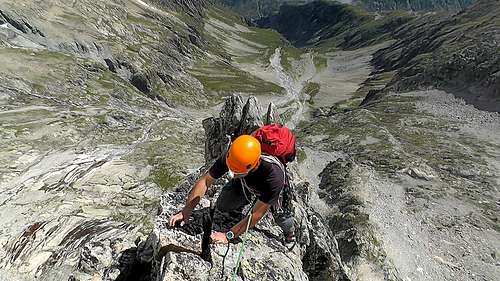
Beautiful equipped combination on excellent rock in a spectacular environment. It's a route that links the Voie du Nain on the spire of Clochetons Gunneng with the Normal route of Aiguille Dibona and allows you to reach the summit of the Dibona with moderate difficulty. An advisable alternative to the Normal route with which it shares the two final pitches.
Approach
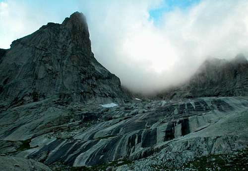
At the Soreiller hut you are just at the bottom of the South face of Aiguille Dibona. From Soreiller refuge, traverse an area of large boulders to the west leading to an easy rocky slope making it possible to cross the crest formed by the last basements SW of Dibona. Take the scree slopes (cairns) to access the firn resulting from the W pass of Soreiller. At the top of the latter 980 m approximately, via a trail on ledges (cairns) and a snow covered area at the beginning of the summer, you reach the foot of Clochetons Gunneng at about 2950m, where you rope up (about 1 h from the hut). The route climb up to the right of Clochetons Gunneng to reach the Brèche of Clochetons. This is the closest route to the obvious rocky corridor that descends from the Clochetons. Belay with cords and 3 spits.
L1 - The first pitch climb from the base (possible snowfield) an easy rock spur on the left, II, 2 bolts on the pitch, belay on 2 bolts
L2 - Climb to the left, the skirt a small roof (pass of 5a, or 4a and A0), possibility of integrating with friend. Stop on 2 bolts.
L3 - Climb to the right then straight onto slabs with good holds, then oblique slightly to the left to the belay on 2 bolts, 4c
L4 - Continue directly on easy slabs with good holds (III+).
L5 - From the belay get up a few meters then cross a small dihedral to the left to head towards the Brèche des Clochetons where it's located the belay (III +). Here it ends the Voie du Nains, on the left you see the North ridge of the Dibona which must be climbed to get to the sharp top of the Dibona.
L6 - From the belay descend a few meters and rejoin the Normal ascent route to Dibona.
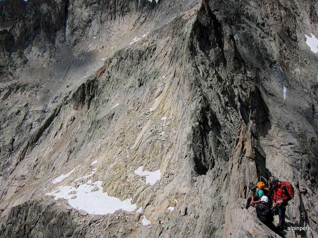
L7 - Climb a dihedral of II+ 25m on the ridge to the belay (spit + chain) - a few pegs (possibility to integrate with friends)
L8 - Always following the thread, go up again for gray plates up to the summit (spit stop + chain) III + / IV- very exposed.
Descent
From the summit you will abseil along the north ridge. It can be crowded on a bright day. An easy and short but exposed downclimb leads to a belay with an abseil anchor, about 15 meters below the summit on the North ridge. Make a 50 m rappel (possibility of descending in two shorter rappels) to arrive on the notch between Aiguille Dibona and Clochetons Gunneng. Make an easy downclimb traversing downward to reach the broad party ledges of Brèche des Clochetons. From here take the ascent route, you just have to walk down along the west face on scree to get back to the Soreiller hut (30-45 min).
Essential Gear
Usual moutain equipment: helmet, 2 x 50 m ropes, harness and helmet, some nuts and small and medium friends if you are right in the level, slings, quickdraws, abseiling equipment. At the beginning of the season you need crampons and suitable shoes. Get information on the snow conditions at the refuge.
Red Tape
No permits, no fees required. Maybe a parking fee is due in full season. Aiguille Dibona is situated inside the Ecrins National Park, so that the usual restrictions and regulations that apply within the parks must be respected.

Hut
Situation: Haute Veneon, foot of Aiguille Dibona
Open: from mid june to mid september
Size: 92 places, 40 in the winter-shelter
Owner: Société des Touristes du Dauphiné
Guardian: Martine Turc
Getting There: from Les Etages
Hut's phone : 0033 04 76 79 08 32 Off Season phone: 0033 04 76 80 28 79
Hanging around...
Around Aiguille Dibona, you can climb on Soreiller Occidental and Oriental, on Tête du Rouget etc... you could easily spend a week there.
You can either stay at the hut or camp. Good camping places about 200m east of the Hut. Nice and quiet, away from the crowd.
Camping
- Les Fetoules * Le Plan du Lac (between Vénosc and Saint Christophe en Oisans, 10 km from Les Etages) 35 pl Brigitte & Bernard Teiller Tél. 04 76 80 23 99
- Camping Municipal *** La Bérarde ( 3 km after les Etages) 165 places Tél. 04 76 79 20 45
When to climb
Best period goes from the end of June to the end of September.
Meteo, Mountain condition and other info
- Bureau des Guides et Accompagnateurs du Veneon La Bérarde - Meije - Ecrins 38520 St Christophe en Oisans
- Summer Tél. 04 76 79 54 83 - Fax 04 76 79 23 12 - Winter Tél. 04 76 80 52 72 - Fax 04 76 79 58 42
Climbing handbook
Two great books that cover climbing in that area :
1. "Oisans Nouveau Oisans Sauvage" by Jean-Michel Cambon
(in which you will find the Voie du Nain described here)
2. "Le Massif des Ecrins - les 100 plus belles" by Gaston Rebuffat
(THE classic handbook)